Grade I listed buildings in the London Borough of Camden
Map all coordinates using OpenStreetMap
Download coordinates as:
- KML
- GPX (all coordinates)
- GPX (primary coordinates)
- GPX (secondary coordinates)
There are over 9,000 Grade I listed buildings in England. This page is a list of these buildings in the London Borough of Camden.
List of buildings
| Name | Location | Type | Completed [note 1] | Date designated | Grid ref.[note 2] Geo-coordinates | Entry number [note 3] | Image |
|---|---|---|---|---|---|---|---|
| All Saints Greek Orthodox Church | Camden Street, Camden Town NW1 0JA | Church | 1822–24 | 10 June 1954 | TQ2924683849 51°32′20″N 0°08′16″W / 51.538753°N 0.137801°W / 51.538753; -0.137801 (All Saints Greek Orthodox Church) | 1244162 | 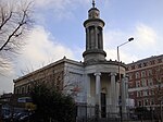 More images |
| Burgh House | New End Square, Hampstead NW3 1LT | House; includes Hampstead Museum | 1703–1704 c. 1703–1704 | 11 August 1950 | TQ2660685947 51°33′30″N 0°10′30″W / 51.558205°N 0.175092°W / 51.558205; -0.175092 (Burgh House) | 1113163 |  More images |
| Charles Dickens House and attached railings | 48 Doughty Street, Bloomsbury WC1N 2LX | Terraced house | 1807–1809 c. 1807–1809 | 10 June 1954 | TQ3078082201 51°31′25″N 0°06′59″W / 51.52359°N 0.116306°W / 51.52359; -0.116306 (Charles Dickens House and attached railings) | 1356735 |  More images |
| Church of Christ the King and attached railings and walls | Gordon Square, Bloomsbury WC1H 0AG | Church | 1851–54 | 10 June 1954 | TQ2972182159 51°31′24″N 0°07′54″W / 51.523457°N 0.131578°W / 51.523457; -0.131578 (Church of Christ the King and attached railings and walls) | 1113038 | 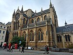 More images |
| Church of St George and attached railings, gates and lamps | Bloomsbury Way, Bloomsbury WC1A 2SA | Church | 1716–31 | 24 October 1951 | TQ3020981536 51°31′04″N 0°07′29″W / 51.517746°N 0.124778°W / 51.517746; -0.124778 (Church of St George and attached railings, gates and lamps) | 1272341 |  More images |
| Church of St Giles in the Fields | St Giles High Street, Covent Garden WC2H 8LG | Church | 1731–33 | 24 October 1951 | TQ2996381260 51°30′55″N 0°07′42″W / 51.515322°N 0.128423°W / 51.515322; -0.128423 (Church of St Giles in the Fields) | 1245864 |  More images |
| Church of St John | Downshire Hill, Hampstead NW3 1NU | Church | 1818–23 | 11 August 1950 | TQ2698285697 51°33′21″N 0°10′11″W / 51.555874°N 0.169761°W / 51.555874; -0.169761 (Church of St John) | 1078270 |  More images |
| Church of St John | Church Row, Hampstead NW3 6UU | Church | 1747–52 | 11 August 1950 | TQ2619085615 51°33′19″N 0°10′52″W / 51.555315°N 0.181208°W / 51.555315; -0.181208 (Church of St John) | 1271918 |  More images |
| Church of St Martin | Vicars Road, Gospel Oak NW5 4NL | Church | 1864–66 | 10 June 1954 | TQ2816285282 51°33′07″N 0°09′10″W / 51.551878°N 0.152901°W / 51.551878; -0.152901 (Church of St Martin) | 1379098 |  More images |
| Church of St Pancras | Upper Woburn Place, St Pancras NW1 2BA | Parish church | 1819–22 | 10 June 1954 | TQ2981782577 51°31′38″N 0°07′48″W / 51.527191°N 0.130041°W / 51.527191; -0.130041 (Church of St Pancras) | 1379062 | 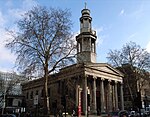 More images |
| Church of St Stephen | Pond Street, Hampstead NW3 2PP | Church | 1869–1871 c. 1869–1871 | 14 May 1974 | TQ2708785399 51°33′11″N 0°10′06″W / 51.553172°N 0.168355°W / 51.553172; -0.168355 (Church of St Stephen) | 1130394 |  More images |
| Fenton House | Hampstead Grove, Hampstead NW3 6SP | Detached house | 1693 | 11 August 1950 | TQ2628586014 51°33′32″N 0°10′47″W / 51.558879°N 0.179696°W / 51.558879; -0.179696 (Fenton House) | 1378648 |  More images |
| Gloucester Lodge (no.12) Gloucester House (no.14) and attached boundary wall | Outer Circle, Regent's Park NW1 4HA | Semi-detached house | 1827–28 | 14 May 1974 | TQ2858583423 51°32′06″N 0°08′51″W / 51.535076°N 0.147482°W / 51.535076; -0.147482 (Gloucester Lodge (no.12) Gloucester House (no.14) and attached boundary wall) | 1078323 |  |
| Institute of St Marcellina | Ellerdale Road, Hampstead NW3 6BD | House | 1874–76 | 11 August 1950 | TQ2632785528 51°33′16″N 0°10′45″W / 51.554502°N 0.179264°W / 51.554502; -0.179264 (Institute of St Marcellina) | 1078274 |  More images |
| Keats House | 10 Keats Grove, Hampstead NW3 2RR | House | 1838–39 | 11 August 1950 | TQ2710885666 51°33′20″N 0°10′05″W / 51.555567°N 0.167956°W / 51.555567; -0.167956 (Keats House) | 1379221 |  More images |
| Kenwood House (Iveagh Bequest) | Hampstead Lane, Hampstead NW3 7JR | Villa | 1767–1768 c. 1767–1768 | 10 June 1954 | TQ2708587418 51°34′17″N 0°10′04″W / 51.571317°N 0.167655°W / 51.571317; -0.167655 (Kenwood House (Iveagh Bequest)) | 1379242 |  More images |
| King's Cross Station | Euston Road at York Way, Pentonville N1C 4AL | Railway station | 1850–52 | 10 June 1954 | TQ3026983130 51°31′55″N 0°07′24″W / 51.532057°N 0.123325°W / 51.532057; -0.123325 (King's Cross Station) | 1078328 |  More images |
| Lindsey House and attached railings, piers and lamp brackets | 59–60 Lincoln's Inn Fields, Holborn WC2A 3BP | House | 1638–41 | 24 October 1951 | TQ3064981338 51°30′57″N 0°07′07″W / 51.515865°N 0.118513°W / 51.515865; -0.118513 (Lindsey House and attached railings, piers and lamp brackets) | 1379333 | 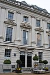 More images |
| Numbers 1–10 Bedford Square and attached railings | Bedford Square, Bloomsbury WC1B 3RA | House | 1880 | 24 October 1951 | TQ2991781702 51°31′09″N 0°07′44″W / 51.519305°N 0.128923°W / 51.519305; -0.128923 (Numbers 1–10 Bedford Square and attached railings) | 1272304 |  More images |
| Number 11 Bedford Square and attached railings | Bedford Square, Bloomsbury WC1B 3RA | Terraced house | 1776–81 | 24 October 1951 | TQ2987681766 51°31′12″N 0°07′46″W / 51.51989°N 0.12949°W / 51.51989; -0.12949 (Number 11 Bedford Square and attached railings) | 1272315 |  More images |
| Numbers 12–27 Bedford Square and attached railings | Bedford Square, Bloomsbury WC1B 3RA | House | 1776–81 | 24 October 1951 | TQ2979181708 51°31′10″N 0°07′51″W / 51.519388°N 0.130735°W / 51.519388; -0.130735 (Numbers 12–27 Bedford Square and attached railings) | 1244546 |  More images |
| Numbers 28–38 Bedford Square and attached railings | Bedford Square, Bloomsbury WC1B 3RA | House | 18th century | 24 October 1951 | TQ2977781604 51°31′06″N 0°07′52″W / 51.518456°N 0.130975°W / 51.518456; -0.130975 (Numbers 28–38 Bedford Square and attached railings) | 1244548 | 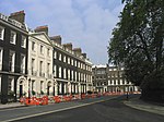 |
| Numbers 40–54 Bedford Square and attached railings | Bedford Square, Bloomsbury WC1B 3RA | Terrace | 1776–81 | 24 October 1951 | TQ2987781608 51°31′06″N 0°07′46″W / 51.518469°N 0.129533°W / 51.518469; -0.129533 (Numbers 40–54 Bedford Square and attached railings) | 1244553 |  |
| Numbers 1, 1a and 2–8 Fitzroy Square and attached railings and lamp holders | Fitzroy Square, Fitzrovia W1T 5HF | House | 1792–1794 c. 1792–1794 | 10 June 1954 | TQ2917382127 51°31′24″N 0°08′22″W / 51.523295°N 0.139484°W / 51.523295; -0.139484 (Numbers 1, 1a and 2–8 Fitzroy Square and attached railings and lamp holders) | 1112991 |  More images |
| Numbers 1, 2 and 3 Albany Terrace and attached railings | off Marylebone Road, Regent's Park NW1 4DS | Terrace | 1823–1825 c. 1823–1825 | 14 May 1974 | TQ2879082229 51°31′27″N 0°08′42″W / 51.524299°N 0.144964°W / 51.524299; -0.144964 (Numbers 1, 2 and 3 Albany Terrace and attached railings) | 1113116 |  More images |
| Numbers 1–10 Cambridge Terrace and attached railings | off Outer Circle East, Regent's Park NW1 4DS | House | 1825 | 14 May 1974 | TQ2875782557 51°31′38″N 0°08′43″W / 51.527254°N 0.14532°W / 51.527254; -0.14532 (Numbers 1–10 Cambridge Terrace and attached railings) | 1244296 | 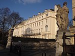 More images |
| Numbers 1–12 Chester Place and attached railings | Chester Place, Regent's Park NW1 4NB | Terrace | 1826 c. 1826 | 10 June 1954 | TQ2876382945 51°31′51″N 0°08′42″W / 51.53074°N 0.145092°W / 51.53074; -0.145092 (Numbers 1–12 Chester Place and attached railings) | 1242936 | 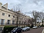 More images |
| Numbers 12 and 13 New Square and attached railings | Lincoln's Inn, Holborn WC2A 3LJ | Terraced house | 1534 | 24 October 1951 | TQ3101081368 51°30′58″N 0°06′48″W / 51.516051°N 0.113303°W / 51.516051; -0.113303 (Numbers 12 and 13 New Square and attached railings) | 1379305 |  More images |
| Numbers 13–24 Park Square East and attached railings, the Diorama, Bedford College Annexe | Park Square, Regent's Park NW1 4LH | Apartment | 1823–1825 c. 1823–1825 | 14 May 1974 | TQ2876982273 51°31′29″N 0°08′43″W / 51.524699°N 0.145251°W / 51.524699; -0.145251 (Numbers 13–24 Park Square East and attached railings, the Diorama, Bedford College Annexe) | 1322054 |  More images |
| Numbers 1–4 Cumberland Place and attached balustrades and railings | Outer Circle East, Regent's Park NW1 4NA | House | 1828 c. 1828 | 14 May 1974 | TQ2872582949 51°31′51″N 0°08′44″W / 51.530784°N 0.145638°W / 51.530784; -0.145638 (Numbers 1–4 Cumberland Place and attached balustrades and railings) | 1067384 |  More images |
| 1–42 Chester Terrace and attached railings and linking arches | Outer Circle East, Regent's Park NW1 4NL | Semi-detached house | 1825 c. 1825 | 14 May 1974 | TQ2875582764 51°31′45″N 0°08′43″W / 51.529115°N 0.145273°W / 51.529115; -0.145273 (1–42 Chester Terrace and attached railings and linking arches) | 1271885 |  More images |
| 1–59 Cumberland Terrace and attached railings | Outer Circle East, Regent's Park NW1 4HS | Manor house | 1827 c. 1827 | 14 May 1974 | TQ2868883102 51°31′56″N 0°08′46″W / 51.532167°N 0.146115°W / 51.532167; -0.146115 (1–59 Cumberland Terrace and attached railings) | 1067386 |  More images |
| Numbers 1–7 and attached railings and lamp holder | Lincoln's Inn Fields, Holborn WC2A 3BP | House | 1775–1845 | 24 October 1951 | TQ3094681527 51°31′03″N 0°06′51″W / 51.517495°N 0.114165°W / 51.517495; -0.114165 (Numbers 1–7 and attached railings and lamp holder) | 1379318 | 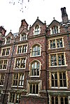 More images |
| Numbers 1–8 St Andrews Place and attached railings | Outer Circle East, Regent's Park NW1 4LB | Terrace | 1823 c. 1823 | 14 May 1974 | TQ2877682328 51°31′31″N 0°08′42″W / 51.525192°N 0.14513°W / 51.525192; -0.14513 (Numbers 1–8 St Andrews Place and attached railings) | 1246155 | 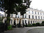 More images |
| Numbers 2 to 11 Gloucester Gate and attached railings | Outer Circle, Regent's Park NW1 4HG | Terrace | 1827 c. 1827 | 14 May 1974 | TQ2860083368 51°32′04″N 0°08′50″W / 51.534578°N 0.147286°W / 51.534578; -0.147286 (Numbers 2 to 11 Gloucester Gate and attached railings) | 1078322 |  |
| Numbers 31 and 33 Albany Street and attached railings | Albany Street, Regent's Park NW1 4BU | Terraced house | 1826 | 6 March 1973 | TQ2882282362 51°31′32″N 0°08′40″W / 51.525487°N 0.144455°W / 51.525487; -0.144455 (Numbers 31 and 33 Albany Street and attached railings) | 1378597 | 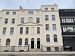 |
| Numbers 8–11 Chancery Lane and attached railings and gates | Chancery Lane, Holborn WC2A 1AF | Terrace | 1775–80 | 24 October 1951 | TQ3098781531 51°31′03″N 0°06′49″W / 51.517521°N 0.113573°W / 51.517521; -0.113573 (Numbers 8–11 Chancery Lane and attached railings and gates) | 1379319 | 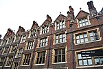 More images |
| Numbers 1, 1a, 1b, 1c and 1d and 2–32 Isokon building | Lawn Road, Hampstead NW3 2XD | Kitchen | 1933–34 | 14 May 1974 | TQ2751985275 51°33′07″N 0°09′44″W / 51.551961°N 0.162172°W / 51.551961; -0.162172 (Numbers 1, 1a, 1b, 1c and 1d and 2–32 Isokon building) | 1379280 |  More images |
| Lincoln's Inn Old Hall and attached gateway | Lincoln's Inn, Holborn WC2A 3TN | Banqueting house | 1489–92 | 24 October 1951 | TQ3103081395 51°30′59″N 0°06′47″W / 51.516289°N 0.113004°W / 51.516289; -0.113004 (Lincoln's Inn Old Hall and attached gateway) | 1379316 |  More images |
| St Etheldreda's Roman Catholic Church and Attached Walls and Piers | 14 Ely Place, Holborn EC1N 6RY | Gate pier | 1300 c. 1300 | 24 October 1951 | TQ3141181673 51°31′07″N 0°06′27″W / 51.518699°N 0.107413°W / 51.518699; -0.107413 (St Etheldreda's Roman Catholic Church and Attached Walls and Piers) | 1078287 | 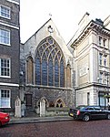 More images |
| Romney's House | 5 Holly Bush Hill, Hampstead NW3 6SH | Terraced house | 1797 | 11 August 1950 | TQ2630685916 51°33′29″N 0°10′46″W / 51.557994°N 0.179428°W / 51.557994; -0.179428 (Romney's House) | 1379069 |  More images |
| Royal College of Physicians | St Andrews Place, Outer Circle Regent's Park NW1 4LB | Library | 1960–64 | 24 April 1998 | TQ2878382390 51°31′33″N 0°08′42″W / 51.525747°N 0.145006°W / 51.525747; -0.145006 (Royal College of Physicians) | 1246159 |  More images |
| Sir John Soane Museum and Attached Railings | 13 Lincoln's Inn Fields, Holborn Wc2A 3BP | Terrace | 1824 c. 1824 | 24 October 1951 | TQ3072081472 51°31′01″N 0°07′03″W / 51.517053°N 0.117441°W / 51.517053; -0.117441 (Sir John Soane Museum and Attached Railings) | 1379327 |  More images |
| St Pancras Station and Former Midland Grand Hotel | Euston Road, Somers Town N1C 4QL | Gate | 1865–69 | 7 November 1967 | TQ3010782977 51°31′51″N 0°07′33″W / 51.530719°N 0.125715°W / 51.530719; -0.125715 (St Pancras Station and Former Midland Grand Hotel) | 1342037 |  More images |
| The British Library, piazza, boundary wall and railings to Ossulston Street, Euston Road and Midland Road | 96 Euston Rd, Somers Town NW1 2DB | Library | 1982–99 | 31 July 2015 | TQ2997082897 51°31′48″N 0°07′40″W / 51.530032°N 0.12771867°W / 51.530032; -0.12771867 (The British Library, piazza, boundary wall and railings to Ossulston Street, Euston Road and Midland Road) | 1426345 |  More images |
| The British Museum | Great Russell Street, Bloomsbury WC1B 3DG | Museum | 1823–26 | 24 October 1951 | TQ3005481721 51°31′10″N 0°07′37″W / 51.519444°N 0.126942°W / 51.519444; -0.126942 (The British Museum) | 1130404 | 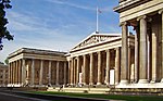 More images |
| The British Museum King Edward VII Galleries and Attached Wall and Lions | Great Russell Street, Bloomsbury WC1B 3DG | Boundary wall | 1905–14 | 24 October 1951 | TQ2999181801 51°31′13″N 0°07′40″W / 51.520178°N 0.12782°W / 51.520178; -0.12782 (The British Museum King Edward VII Galleries and Attached Wall and Lions) | 1322129 |  More images |
| The Chapel | Lincoln's Inn, Holborn WC2A 3AA | Chapel | 1619–23 | 24 October 1951 | TQ3102781425 51°31′00″N 0°06′47″W / 51.51656°N 0.113037°W / 51.51656; -0.113037 (The Chapel) | 1379317 |  More images |
| The Egyptian Avenue and Lebanon Circle (Inner and Outer Circles), Highgate Cemetery | Swains Lane, Highgate N6 6PJ | Catacomb (funerary) | 1838–1839 c. 1838–1839 | 14 May 1974 | TQ2834887135 51°34′07″N 0°08′58″W / 51.568488°N 0.149544°W / 51.568488; -0.149544 (The Egyptian Avenue and Lebanon Circle (Inner and Outer Circles), Highgate Cemetery) | 1271935 |  More images |
| The London Foot Hospital and Attached Railings | 33 Fitzroy Square, Fitzrovia W1P 6AY | Terrace | 1792–1794 c. 1792–1794 | 10 June 1954 | TQ2916582041 51°31′21″N 0°08′23″W / 51.522524°N 0.139631°W / 51.522524; -0.139631 (The London Foot Hospital and Attached Railings) | 1112997 |  More images |
| The National Institute for Social Work Training and Attached Railings and Gates | 5 Tavistock Place, Bloomsbury WC1H 9SN | Conference centre | 1896–98 | 7 April 1960 | TQ3000782361 51°31′31″N 0°07′39″W / 51.525207°N 0.127383°W / 51.525207; -0.127383 (The National Institute for Social Work Training and Attached Railings and Gates) | 1378962 |  More images |
| Tomb of Karl Marx and Family in Highgate (eastern) Cemetery | Swains Lane, Highgate N6 6PJ | Bust | 1956 | 14 May 1974 | TQ2874486891 51°33′58″N 0°08′38″W / 51.566205°N 0.143923°W / 51.566205; -0.143923 (Tomb of Karl Marx and Family in Highgate (eastern) Cemetery) | 1378872 |  More images |
| Tomb of Sir John Soane, His Wife and Son in St Pancras Old Church Gardens | St Pancras Old Church Gardens Pancras Road Camden Town NW1 1UL | Family vault | 1816 | 16 May 1978 | TQ2979383504 51°32′08″N 0°07′48″W / 51.535527°N 0.130045°W / 51.535527; -0.130045 (Tomb of Sir John Soane, His Wife and Son in St Pancras Old Church Gardens) | 1322044 |  More images |
| University College (University of London) and Attached Railings to North and South Wings | University College London, Gower Street Bloomsbury WC1E 6BT | Gate pier | 1848 c. 1848 | 10 June 1954 | TQ2958282298 51°31′29″N 0°08′01″W / 51.524738°N 0.133529°W / 51.524738; -0.133529 (University College (University of London) and Attached Railings to North and South Wings) | 1113056 |  More images |
| 16–23 Old Buildings | Lincoln's Inn Fields, Holborn WC2A 3BP | Kitchen | 1524 c. 1524 | 24 October 1951 | TQ3104181371 51°30′58″N 0°06′46″W / 51.516071°N 0.112855°W / 51.516071; -0.112855 (16–23 Old Buildings) | 1379311 |  |
| 9 and 10 St Andrews Place | St Andrews Place Outer Circle East Regent's Park NW1 4LB | Terraced house | 1826 c. 1826 | 14 May 1974 | TQ2881582360 51°31′32″N 0°08′40″W / 51.52547°N 0.144556°W / 51.52547; -0.144556 (9 and 10 St Andrews Place) | 1246157 |  More images |
See also
Notes
- ^ The date given is the date used by Historic England as significant for the initial building or that of an important part in the structure's description.
- ^ Sometimes known as OSGB36, the grid reference is based on the British national grid reference system used by the Ordnance Survey.
- ^ The "List Entry Number" is a unique number assigned to each listed building and scheduled monument by Historic England.
External links
 Media related to Grade I listed buildings in the London Borough of Camden at Wikimedia Commons
- v
- t
- e
- Bloomsbury
- Camden Town
- Chalk Farm and Haverstock ward
- Fortune Green
- Gospel Oak
- Hampstead (inc. Belsize Park, Frognal, Finchley Road, South Hampstead and Swiss Cottage)
- Hatton Garden (inc. Saffron Hill)
- Kentish Town
- Primrose Hill
- Regent's Park Estate
- St Giles
- St Pancras
- Somers Town
- West Hampstead
| Partly in Camden |
|
|---|

- Ben Uri Gallery & Museum
- Bloomsbury Theatre
- British Library
- British Museum
- Brunswick Centre
- BT Tower
- Camden Arts Centre
- Charles Dickens Museum
- Dominion Theatre
- Donmar Warehouse
- Fenton House
- Foundling Museum
- Freud Museum
- Highgate Cemetery
- Keats House
- Kenwood House
- The Jewish Museum
- O2 Forum Kentish Town
- Petrie Museum of Egyptian Archaeology
- Roundhouse
- Shaftesbury Theatre
- Sir John Soane's Museum
- Wellcome Collection
- West End theatre
open spaces
- Hampstead and Kilburn
- Holborn and St Pancras
rail stations
 Belsize Park
 Camden Road
- Camden Town
- Chalk Farm
- Chancery Lane
 Euston
- Euston tube
- Euston Square
- Finchley Road
- Finchley Road & Frognal
- Goodge Street
- Gospel Oak
- Hampstead
- Hampstead Heath
- Holborn
- Kentish Town
- Kentish Town West
- Kilburn High Road
- King's Cross
- King's Cross St Pancras
- Mornington Crescent
- Russell Square
- St Pancras
- South Hampstead
- Swiss Cottage
- Tottenham Court Road
- Warren Street
- West Hampstead
- West Hampstead (Overground)
- West Hampstead Thameslink


- Blue plaques
- Coat of arms
- Council
- Listed buildings
- Grade I
- Grade II*
- People
- Public art
- Schools
 Category
- Commons

Portals:
 London
 Architecture


