Grade II* listed buildings in the London Borough of Camden
Map all coordinates using OpenStreetMap
Download coordinates as:
- KML
- GPX (all coordinates)
- GPX (primary coordinates)
- GPX (secondary coordinates)
There are over 20,000 Grade II* listed buildings in England. This page is a list of these buildings in the London Borough of Camden.
Buildings
| Name | Location | Type | Completed [note 1] | Date designated | Grid ref.[note 2] Geo-coordinates | Entry number [note 3] | Image |
|---|---|---|---|---|---|---|---|
| Alexandra Road Estate Including Walls, Ramps and Steps Community Centre and Boiler House to Alexandra Road Estate Numbers 1–21 | Camden | Apartment | 1972–1978 | 18 August 1993 | TQ2605683913 51°32′24″N 0°11′01″W / 51.540049°N 0.183749°W / 51.540049; -0.183749 (Alexandra Road Estate Including Walls, Ramps and Steps Community Centre and Boiler House to Alexandra Road Estate Numbers 1–21) | 1130403 | 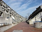 More images |
| Annesley Lodge, 8 Platts Lane | 8 Platts Lane, Hampstead NW3 | Apartment | 1896 | 14 May 1974 | TQ2524385940 51°33′30″N 0°11′41″W / 51.558446°N 0.194745°W / 51.558446; -0.194745 (Annesley Lodge, 8 Platts Lane) | 1139064 |  More images |
| Apothecary House, 47 Highgate West Hill | Highgate West Hill, Highgate N6 | Detached House | c. 1730 | 10 June 1954 | TQ2829487445 51°34′17″N 0°09′01″W / 51.571286°N 0.150209°W / 51.571286; -0.150209 (Apothecary House, 47 Highgate West Hill) | 1379044 |  More images |
| Baptist Church House, 2, 4 and 6, Southampton Row, and Kingsgate House, Catton Street | Camden | Shop | 1901–1903 | 15 February 1982 | TQ3052281567 51°31′05″N 0°07′13″W / 51.517952°N 0.120258°W / 51.517952; -0.120258 (Baptist Church House, 2, 4 and 6, Southampton Row, and Kingsgate House, Catton Street) | 1378782 |  More images |
| Belsize Fire Station | Belsize Park, 36 Lancaster Grove NW3 | Apartment | 1912–1915 | 14 May 1974 | TQ2725784525 51°32′43″N 0°09′58″W / 51.54528°N 0.16622°W / 51.54528; -0.16622 (Belsize Fire Station) | 1379277 |  More images |
| Black Lion Public House | 274 Kilburn High Road | Public House | c. 1898 | 14 May 1974 | TQ2492884302 51°32′38″N 0°12′00″W / 51.543796°N 0.199868°W / 51.543796; -0.199868 (Black Lion Public House) | 1379254 |  More images |
| Boundary Wall and Main Gate to Old Hall | 1–7 South Grove, Highgate N6 | Gate | 18th century | 10 June 1954 | TQ2826987259 51°34′11″N 0°09′02″W / 51.56962°N 0.150638°W / 51.56962; -0.150638 (Boundary Wall and Main Gate to Old Hall) | 1378771 |  |
| Brownlow House and Attached Railings | 50-51 High Holborn, Holborn WC1 | House | Late C17/Early 18th century | 15 January 1973 | TQ3026181225 51°30′54″N 0°07′27″W / 51.514939°N 0.124144°W / 51.514939; -0.124144 (Brownlow House and Attached Railings) | 1244498 |  More images |
| Camden Incline Winding Engine House | Gloucester Avenue, Camden Town | Winder House | 1837 | 18 June 1990 | TQ2837084035 51°32′26″N 0°09′01″W / 51.540624°N 0.150357°W / 51.540624; -0.150357 (Camden Incline Winding Engine House) | 1342073 |  Upload Photo |
| Cannon Hall | 14 Cannon Place, Hampstead NW3 | Coachmans Cottage | Early 18th century | 11 August 1950 | TQ2660286159 51°33′36″N 0°10′30″W / 51.560111°N 0.175073°W / 51.560111; -0.175073 (Cannon Hall) | 1244093 |  More images |
| Cannon Lodge | 12 Cannon Place, Hampstead NW3 | House | Mid 18th century | 14 May 1974 | TQ2659086139 51°33′36″N 0°10′31″W / 51.559934°N 0.175253°W / 51.559934; -0.175253 (Cannon Lodge) | 1272517 |  |
| Central Saint Martins College of Arts and Design (former) | Southampton Row and Theobalds Road, Holborn WC1 | Art School | 1905–1908 | 11 November 1982 | TQ3050081670 51°31′08″N 0°07′14″W / 51.518883°N 0.120537°W / 51.518883; -0.120537 (Central Saint Martins College of Arts and Design (former)) | 1378790 | 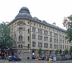 More images |
| Chestnut Lodge and Squires Mount | Squires Mount, Hampstead NW3 | House | Later alterations | 11 August 1950 | TQ2662286195 51°33′38″N 0°10′29″W / 51.56043°N 0.174772°W / 51.56043; -0.174772 (Chestnut Lodge and Squires Mount) | 1378798 | 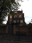 More images |
| St George's Cathedral (formerly Christ Church) | Camden | Church | 1836 | 10 June 1954 | TQ2881782893 51°31′49″N 0°08′40″W / 51.53026°N 0.144333°W / 51.53026; -0.144333 (St George's Cathedral (formerly Christ Church)) | 1378620 |  More images |
| Church House and the Highgate Society | 10, South Grove, Highgate N6 | House | Early 18th century | 10 June 1954 | TQ2842887342 51°34′13″N 0°08′54″W / 51.57033°N 0.148315°W / 51.57033; -0.148315 (Church House and the Highgate Society) | 1378748 |  More images |
| Church of All Hallows | Camden | Church | 1889–1901 | 10 June 1954 | TQ2786685684 51°33′20″N 0°09′25″W / 51.555558°N 0.157022°W / 51.555558; -0.157022 (Church of All Hallows) | 1378658 |  More images |
| Church of St Alban the Martyr | Camden | Church | 1861–1862 | 24 October 1951 | TQ3116881781 51°31′11″N 0°06′39″W / 51.519726°N 0.110873°W / 51.519726; -0.110873 (Church of St Alban the Martyr) | 1272353 |  More images |
| Church of St George the Martyr | Camden | Chapel of Ease | c. 1706 | 24 October 1951 | TQ3036281901 51°31′16″N 0°07′21″W / 51.520991°N 0.122439°W / 51.520991; -0.122439 (Church of St George the Martyr) | 1245485 |  More images |
| Church of St Luke | Camden | Church Hall | 1897–1899 | 14 May 1974 | TQ2526785911 51°33′29″N 0°11′40″W / 51.55818°N 0.194409°W / 51.55818; -0.194409 (Church of St Luke) | 1379248 |  More images |
| Church of St Luke with St Paul | Camden | Church | c1867-1869 | 10 June 1954 | TQ2949784930 51°32′54″N 0°08′02″W / 51.54841°N 0.133786°W / 51.54841; -0.133786 (Church of St Luke with St Paul) | 1113230 |  More images |
| Church of St Mary Brookfield | Camden | Church | 1869–1875 | 10 June 1954 | TQ2896486183 51°33′35″N 0°08′28″W / 51.559792°N 0.14101°W / 51.559792; -0.14101 (Church of St Mary Brookfield) | 1067389 |  More images |
| Church of St Mary Magdalene | Camden | Church | 1849–1852 | 10 June 1954 | TQ2895782422 51°31′34″N 0°08′33″W / 51.525995°N 0.142488°W / 51.525995; -0.142488 (Church of St Mary Magdalene) | 1113157 | 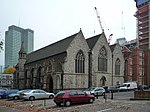 More images |
| Church of St Michael | Camden | Church | 1880–1881 | 10 June 1954 | TQ2898583993 51°32′24″N 0°08′29″W / 51.540107°N 0.141509°W / 51.540107; -0.141509 (Church of St Michael) | 1244156 |  More images |
| Church of St Michael | South Grove, Highgate N6 | Church | 1832 | 10 June 1954 | TQ2829587174 51°34′08″N 0°09′01″W / 51.568851°N 0.150294°W / 51.568851; -0.150294 (Church of St Michael) | 1378767 |  More images |
| Church of St Silas the Martyr | Camden | Church | 1911–1913 | 10 June 1954 | TQ2821084693 51°32′48″N 0°09′09″W / 51.546574°N 0.152423°W / 51.546574; -0.152423 (Church of St Silas the Martyr) | 1245853 | 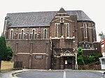 More images |
| Circular Ward and Attached Ablution and Water Tank Tower at Former New End Hospital | Camden | Kitchen | 1884 | 17 October 1986 | TQ2640785961 51°33′30″N 0°10′41″W / 51.558376°N 0.177956°W / 51.558376; -0.177956 (Circular Ward and Attached Ablution and Water Tank Tower at Former New End Hospital) | 1322108 | Upload Photo |
| Cloth Hill | 6, The Mount, Hampstead NW3 | House | c. 1694 | 11 August 1950 | TQ2632485933 51°33′29″N 0°10′45″W / 51.558143°N 0.179162°W / 51.558143; -0.179162 (Cloth Hill) | 1378993 |  More images |
| Congress House Including Forecourt and Courtyard Sculptures | Camden | Sculpture | 1953–1957 | 29 March 1988 | TQ2994981473 51°31′02″N 0°07′43″W / 51.51724°N 0.128546°W / 51.51724; -0.128546 (Congress House Including Forecourt and Courtyard Sculptures) | 1113223 | 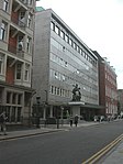 More images |
| Cumberland Footbridge over Grand Union Canal to Outer Circle, Regents Park | Camden | Gate Pier | c. 1864 | 16 May 1978 | TQ2822783649 51°32′14″N 0°09′09″W / 51.537188°N 0.152558°W / 51.537188; -0.152558 (Cumberland Footbridge over Grand Union Canal to Outer Circle, Regents Park) | 1329910 |  More images |
| Elm Lodge and Attached Garden Wall | Elm Row, Hampstead NW3 | House | c. 1732 | 14 May 1974 | TQ2639586026 51°33′32″N 0°10′41″W / 51.558963°N 0.178105°W / 51.558963; -0.178105 (Elm Lodge and Attached Garden Wall) | 1078276 |  More images |
| Englefield House | 23, Highgate High Street, Highgate | Terraced House | c. 1710 | 10 June 1954 | TQ2851287365 51°34′14″N 0°08′50″W / 51.570518°N 0.147095°W / 51.570518; -0.147095 (Englefield House) | 1378900 |  More images |
| Euston Fire Station Including Boundary Walls, Gatepiers and Railings | Camden | Apartment | 1901–1902 | 14 May 1974 | TQ2976482631 51°31′40″N 0°07′51″W / 51.527689°N 0.130785°W / 51.527689; -0.130785 (Euston Fire Station Including Boundary Walls, Gatepiers and Railings) | 1342074 |  More images |
| Forecourt Railings and Gate to Number 10 | 10, South Grove, Camden | Gate | 18th century | 10 June 1954 | TQ2842487355 51°34′14″N 0°08′54″W / 51.570448°N 0.148368°W / 51.570448; -0.148368 (Forecourt Railings and Gate to Number 10) | 1378750 |  |
| Freemasons' Hall | Camden | Freemasons Hall | 1927–1933 | 9 March 1982 | TQ3047081244 51°30′54″N 0°07′16″W / 51.515062°N 0.121126°W / 51.515062; -0.121126 (Freemasons' Hall) | 1113218 |  More images |
| Frognal Grove Including Former Stable Range | 105–111 Frognal, Hampstead NW3 | Semi Detached House | 1950s | 11 August 1950 | TQ2612585917 51°33′29″N 0°10′55″W / 51.558043°N 0.182037°W / 51.558043; -0.182037 (Frognal Grove Including Former Stable Range) | 1113081 |  More images |
| Gardnor House | Flask Walk, Hampstead NW3 | House | c. 1736 | 11 August 1950 | TQ2658385858 51°33′27″N 0°10′32″W / 51.557411°N 0.175455°W / 51.557411; -0.175455 (Gardnor House) | 1322202 |  More images |
| Grand Connaught Rooms | Holborn, Camden | Freemasons Hall | 1774 | 17 September 2010 | TQ3052781284 51°30′55″N 0°07′13″W / 51.515408°N 0.12029°W / 51.515408; -0.12029 (Grand Connaught Rooms) | 1393970 | 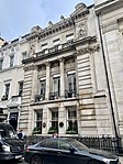 More images |
| Grays Inn Square Number 1 and Attached Railings | Camden | Legal Chambers | c. 1776 | 24 October 1951 | TQ3100781738 51°31′10″N 0°06′48″W / 51.519377°N 0.113208°W / 51.519377; -0.113208 (Grays Inn Square Number 1 and Attached Railings) | 1322145 | 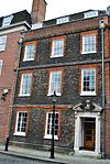 |
| Grays Inn Square Numbers 12, 13 and 14, Gatehouse and Attached Railings | Camden | Terrace | 1684–1688 | 24 October 1951 | TQ3106481774 51°31′11″N 0°06′45″W / 51.519687°N 0.112374°W / 51.519687; -0.112374 (Grays Inn Square Numbers 12, 13 and 14, Gatehouse and Attached Railings) | 1322147 |  |
| Grays Inn Square Numbers 6, 7 and 8 and Attached Railings | Camden | Terrace | c. 1676 | 24 October 1951 | TQ3100781823 51°31′13″N 0°06′47″W / 51.520141°N 0.113177°W / 51.520141; -0.113177 (Grays Inn Square Numbers 6, 7 and 8 and Attached Railings) | 1322146 | 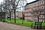 |
| St Christopher's Chapel, Great Ormond Street Hospital | Camden | Chapel | 1871–1876 | 10 March 1980 | TQ3046082042 51°31′20″N 0°07′16″W / 51.522235°N 0.120975°W / 51.522235; -0.120975 (St Christopher's Chapel, Great Ormond Street Hospital) | 1113211 |  More images |
| Hampstead Synagogue | Camden | Synagogue | 1892–1901 | 25 September 1989 | TQ2545884984 51°32′59″N 0°11′31″W / 51.549807°N 0.191986°W / 51.549807; -0.191986 (Hampstead Synagogue) | 1271984 |  More images |
| Heal and Son Limited Including Habitat | Camden | Department Store | 1914–1917 | 14 May 1974 | TQ2953181906 51°31′16″N 0°08′04″W / 51.521227°N 0.134408°W / 51.521227; -0.134408 (Heal and Son Limited Including Habitat) | 1379023 |  More images |
| Heath House | 1 North End Way, Hampstead NW3 | House | Early 18th century | 14 May 1974 | TQ2628586484 51°33′47″N 0°10′46″W / 51.563103°N 0.179527°W / 51.563103; -0.179527 (Heath House) | 1113183 |  More images |
| Horse Hospital with Ramps and Boundary Wall at North of Site | Stable Yard, Stables Market, Chalk Farm Road, Camden Town, NW1 | Stable | 1882-3 | 30 September 1981 | TQ2850984257 51°32′33″N 0°08′54″W / 51.542588°N 0.148273°W / 51.542588; -0.148273 (Horse Hospital with Ramps and Boundary Wall at North of Site) | 1258100 | 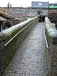 |
| House and Attached Garage | 62 Camden Mews, Camden Town, NW1 | House | 1962-5 | 15 May 2007 | TQ2969684724 51°32′47″N 0°07′52″W / 51.546513°N 0.130994°W / 51.546513; -0.130994 (House and Attached Garage) | 1392599 |  More images |
| Institute of Education, Clore Institute of Advanced Legal Studies and Accommodation for University College | Camden, Camden | Conference Centre | 1970–1976 | 4 December 2000 | TQ2995482136 51°31′24″N 0°07′42″W / 51.523197°N 0.12823°W / 51.523197; -0.12823 (Institute of Education, Clore Institute of Advanced Legal Studies and Accommodation for University College) | 1246932 |  More images |
| James Smith and Sons, Hazelwood House | Hazelwood House, 53 New Oxford Street WC1A | Workshop | Mid 19th century | 11 January 1999 | TQ3008181432 51°31′01″N 0°07′36″W / 51.516841°N 0.12666°W / 51.516841; -0.12666 (James Smith and Sons, Hazelwood House) | 1113171 |  More images |
| Lauderdale House | Waterlow Park, Highgate N6 | House | c. 1760 | 10 June 1954 | TQ2877387236 51°34′09″N 0°08′36″W / 51.569299°N 0.143378°W / 51.569299; -0.143378 (Lauderdale House) | 1379128 |  More images |
| Lloyds Bank Numbers 1 and 3 with Railings and Gates to South | 40 Rosslyn Hill, Hampstead NW3 | Terraced House | c1895-1896 | 14 May 1974 | TQ2679085599 51°33′18″N 0°10′21″W / 51.555037°N 0.172564°W / 51.555037; -0.172564 (Lloyds Bank Numbers 1 and 3 with Railings and Gates to South) | 1130392 |  More images |
| London and North Western Railway War Memorial | Euston station | War memorial | 1921 | 11 January 1999 | TQ2964182578 51°31′39″N 0°07′56″W / 51.527432°N 0.132150°W / 51.527432; -0.132150 (London and North Western Railway War Memorial) | 1342044 | 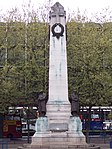 More images |
| Main Entrance Gateway, Railings and Attached Lodges to the British Museum | Camden | Porters Lodge | 1849 | 14 May 1974 | TQ3013981619 51°31′07″N 0°07′33″W / 51.518508°N 0.125755°W / 51.518508; -0.125755 (Main Entrance Gateway, Railings and Attached Lodges to the British Museum) | 1130406 |  |
| Mausoleum of Julius Beer in Highgate (western) Cemetery | Camden | Mausoleum | c. 1878 | 14 May 1974 | TQ2833487151 51°34′07″N 0°08′59″W / 51.568635°N 0.14974°W / 51.568635; -0.14974 (Mausoleum of Julius Beer in Highgate (western) Cemetery) | 1378887 |  More images |
| Monument in Courtyard | Camden | Column | c. 1828 | 14 May 1974 | TQ2861883270 51°32′01″N 0°08′49″W / 51.533693°N 0.147062°W / 51.533693; -0.147062 (Monument in Courtyard) | 1245870 | 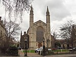 |
| New Hall | Lincolns Inn, Camden | Banqueting House | c1843-1845 | 24 October 1951 | TQ3092381408 51°30′59″N 0°06′52″W / 51.516431°N 0.114541°W / 51.516431; -0.114541 (New Hall) | 1379298 |  More images |
| New Hall Library | Lincolns Inn, Camden | Public Library | Circa 1843–1845 | 24 October 1951 | TQ3091481435 51°31′00″N 0°06′53″W / 51.516676°N 0.11466°W / 51.516676; -0.11466 (New Hall Library) | 1379299 | 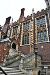 More images |
| Nos. 1–9 Melton Street and Attached Railings | Camden | Government Office | 2011 | 14 May 1974 | TQ2951282501 51°31′36″N 0°08′04″W / 51.526578°N 0.134463°W / 51.526578; -0.134463 (Nos. 1–9 Melton Street and Attached Railings) | 1113131 |  More images |
| Number 1-3 and 6–9 and Attached Railings | Camden | House | 1974 | 14 May 1974 | TQ2861883296 51°32′02″N 0°08′49″W / 51.533927°N 0.147053°W / 51.533927; -0.147053 (Number 1-3 and 6–9 and Attached Railings) | 1245868 | |
| Number 15 and Attached Boundary Walls and Piers | 15 Gloucester Gate, Regent's Park, NW1 | Villa | 1827–1828 | 14 May 1974 | TQ2860983441 51°32′07″N 0°08′50″W / 51.535232°N 0.14713°W / 51.535232; -0.14713 (Number 15 and Attached Boundary Walls and Piers) | 1078325 |  |
| Number 2 and Attached Railings | 2 Marylebone Road, Regent's Park, NW1 | House | Later alterations | 10 June 1954 | TQ2882082235 51°31′28″N 0°08′40″W / 51.524346°N 0.14453°W / 51.524346; -0.14453 (Number 2 and Attached Railings) | 1113114 |  More images |
| Number 20 and Attached Railings | 20 Church Row, Hampstead NW3 | Terraced House | c. 1720 | 11 August 1950 | TQ2630485622 51°33′19″N 0°10′46″W / 51.555352°N 0.179562°W / 51.555352; -0.179562 (Number 20 and Attached Railings) | 1271913 |  |
| Number 21 and Attached Railings to Front and Brick Walls to Rear | 21 Church Row, Hampstead NW3 | House | Late 19th century | 11 August 1950 | TQ2631085624 51°33′19″N 0°10′46″W / 51.555369°N 0.179475°W / 51.555369; -0.179475 (Number 21 and Attached Railings to Front and Brick Walls to Rear) | 1271914 | 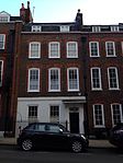 |
| Number 22 and Attached Railings | 22 Church Row, Hampstead NW3 | House | Late 19th century | 11 August 1950 | TQ2631785626 51°33′19″N 0°10′46″W / 51.555385°N 0.179373°W / 51.555385; -0.179373 (Number 22 and Attached Railings) | 1271915 |  |
| Number 23 and Attached Railings | 23 Church Row, Hampstead NW3 | House | Late 19th century | 11 August 1950 | TQ2632485627 51°33′19″N 0°10′45″W / 51.555393°N 0.179272°W / 51.555393; -0.179272 (Number 23 and Attached Railings) | 1271916 | 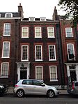 |
| Number 3 and Attached Railings, Wall and Lamp | 3, The Grove, Highgate | House | c. 1688 | 10 June 1954 | TQ2818187264 51°34′11″N 0°09′07″W / 51.569685°N 0.151905°W / 51.569685; -0.151905 (Number 3 and Attached Railings, Wall and Lamp) | 1378978 | 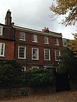 More images |
| Number 3 to 16 and Attached Railings | Camden | Terrace | 1720–1724 | 24 October 1951 | TQ3075981948 51°31′17″N 0°07′00″W / 51.521322°N 0.116703°W / 51.521322; -0.116703 (Number 3 to 16 and Attached Railings) | 1113197 |  |
| Number 4 and Attached Railings, Wall and Lamp | 4, The Grove, Highgate | House | c. 1688 | 10 June 1954 | TQ2818087276 51°34′11″N 0°09′07″W / 51.569793°N 0.151915°W / 51.569793; -0.151915 (Number 4 and Attached Railings, Wall and Lamp) | 1378979 | 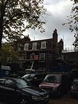 |
| Number 40 and Attached Railings, Walls and Gates | Well Walk, Hampstead NW3 | House | Late 19th century | 11 August 1950 | TQ2672486033 51°33′32″N 0°10′24″W / 51.558952°N 0.17336°W / 51.558952; -0.17336 (Number 40 and Attached Railings, Walls and Gates) | 1379169 |  More images |
| Number 46 and Attached Railings | 46 Grafton Terrace, Belsize Park, NW5 | Terraced House | Mid 19th century | 14 May 1974 | TQ2798585053 51°32′59″N 0°09′20″W / 51.54986°N 0.155536°W / 51.54986; -0.155536 (Number 46 and Attached Railings) | 1113066 | Upload Photo |
| Number 46 and Attached Railings and Wall | 46 Well Walk, Hampstead NW3 | House | Late 18th century | 11 August 1950 | TQ2673286047 51°33′33″N 0°10′24″W / 51.559076°N 0.173239°W / 51.559076; -0.173239 (Number 46 and Attached Railings and Wall) | 1379170 |  More images |
| Number 58 and Attached Railings | Camden | Terraced House | c. 1792 | 19 November 1970 | TQ2927282153 51°31′25″N 0°08′17″W / 51.523506°N 0.138048°W / 51.523506; -0.138048 (Number 58 and Attached Railings) | 1113071 |  More images |
| Number 6 and Attached Railings | Camden | Apartment | 1914 | 24 October 1951 | TQ3033481952 51°31′17″N 0°07′22″W / 51.521456°N 0.122823°W / 51.521456; -0.122823 (Number 6 and Attached Railings) | 1139091 |  |
| Number 6 and Attached Railings, Wall and Lamp | 6, The Grove, Highgate | House | C20 | 10 June 1954 | TQ2817787308 51°34′12″N 0°09′07″W / 51.570082°N 0.151947°W / 51.570082; -0.151947 (Number 6 and Attached Railings, Wall and Lamp) | 1378981 |  |
| Number 9 and Attached Railings and Gate | 9 Church Row, Hampstead NW3 | House | Late 19th century | 11 August 1950 | TQ2629085654 51°33′20″N 0°10′47″W / 51.555643°N 0.179753°W / 51.555643; -0.179753 (Number 9 and Attached Railings and Gate) | 1067344 |  More images |
| Number 99 and Attached Railings to Areas | 99 Great Russell Street, Holborn, WC1B | Terraced House | 1680–1700 | 24 October 1951 | TQ2995381530 51°31′04″N 0°07′42″W / 51.517751°N 0.128467°W / 51.517751; -0.128467 (Number 99 and Attached Railings to Areas) | 1330376 | 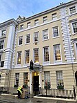 |
| Numbers 1 and 3 and Attached Boundary Walls | 1 and 3 Lyndurst Terrace, Belsize Park NW3 | House | 1868 | 30 September 1983 | TQ2665485264 51°33′07″N 0°10′29″W / 51.552057°N 0.174645°W / 51.552057; -0.174645 (Numbers 1 and 3 and Attached Boundary Walls) | 1379406 |  More images |
| Numbers 1 to 7 and Attached Railings and Lamp Holder | 1-7 Great Ormond Street, Holborn, WC1N | Terrace | 1710–1715 | 24 October 1951 | TQ3067782072 51°31′21″N 0°07′04″W / 51.522455°N 0.117838°W / 51.522455; -0.117838 (Numbers 1 to 7 and Attached Railings and Lamp Holder) | 1322066 |  |
| Numbers 11, 12 and 15–19 and Attached Railings | 11, 12 and 15–19 Fitzroy Square, Fitzrovia, W1T | Terrace | c1827-1828 | 10 June 1954 | TQ2909882131 51°31′24″N 0°08′26″W / 51.523348°N 0.140563°W / 51.523348; -0.140563 (Numbers 11, 12 and 15–19 and Attached Railings) | 1112995 |  |
| Numbers 1–11 and Attached Railings | Lincolns Inn, Camden | Gate | c1690-1697 | 24 October 1951 | TQ3099981260 51°30′54″N 0°06′49″W / 51.515083°N 0.113501°W / 51.515083; -0.113501 (Numbers 1–11 and Attached Railings) | 1379303 |  |
| Numbers 11–26 and Attached Railings, Byron Court (number 26) | Camden | House | c. 1950 | 10 June 1954 | TQ3068882380 51°31′31″N 0°07′03″W / 51.52522°N 0.117565°W / 51.52522; -0.117565 (Numbers 11–26 and Attached Railings, Byron Court (number 26)) | 1113118 |  |
| Numbers 14–22 and Attached Railings | 14-22 Southampton Place, Holborn, WC1A | House | 19th century | 24 October 1951 | TQ3040181560 51°31′05″N 0°07′19″W / 51.517918°N 0.122003°W / 51.517918; -0.122003 (Numbers 14–22 and Attached Railings) | 1378773 |  |
| Numbers 15 and 16 and Attached Railings | 15 and 16 Bedford Row, Holborn, WC1A | House | 1717–1718 | 24 October 1951 | TQ3081681821 51°31′13″N 0°06′57″W / 51.520167°N 0.115929°W / 51.520167; -0.115929 (Numbers 15 and 16 and Attached Railings) | 1244605 |  |
| Numbers 17, 19 and 21 and Attached Railings | 17, 19, 21, Highgate High Street, Highgate, N6 | Terrace | 1733 | 10 June 1954 | TQ2852387360 51°34′14″N 0°08′49″W / 51.57047°N 0.146938°W / 51.57047; -0.146938 (Numbers 17, 19 and 21 and Attached Railings) | 1378899 | 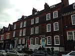 More images |
| Numbers 18 and 19 and Attached Railings to Front and Brick Walls to Rear | 18 and 19 Church Row, Hampstead NW3 | House | Late 19th century | 11 August 1950 | TQ2629585620 51°33′19″N 0°10′47″W / 51.555336°N 0.179693°W / 51.555336; -0.179693 (Numbers 18 and 19 and Attached Railings to Front and Brick Walls to Rear) | 1271912 |  |
| Numbers 1–8 and Attached Railings | 1-8 Southampton Place, Holborn, WC1A | Terrace | c1758-1763 | 24 October 1951 | TQ3042081587 51°31′05″N 0°07′18″W / 51.518156°N 0.12172°W / 51.518156; -0.12172 (Numbers 1–8 and Attached Railings) | 1378772 |  |
| Numbers 1–8, 10–14 and 17–19 and Attached Railings | 1–8, 10–14 and 17–19 Park Village West, Regent's Park, NW1 | Villa | c. 1832 | 14 May 1974 | TQ2872583366 51°32′04″N 0°08′44″W / 51.534532°N 0.145485°W / 51.534532; -0.145485 (Numbers 1–8, 10–14 and 17–19 and Attached Railings) | 1322057 |  More images |
| Numbers 20–32 and Attached Railings | Camden | Terrace | c1832-1835 | 10 June 1954 | TQ2908682063 51°31′22″N 0°08′27″W / 51.52274°N 0.140761°W / 51.52274; -0.140761 (Numbers 20–32 and Attached Railings) | 1112996 |  More images |
| Numbers 2–16, 22–34, 36a and 36b and Attached Railings | 2–16, 22–34, 36a and 36b Park Village East, Regent's Park, NW1 | Villa | 1825–1836 | 14 May 1974 | TQ2879383370 51°32′04″N 0°08′40″W / 51.534552°N 0.144504°W / 51.534552; -0.144504 (Numbers 2–16, 22–34, 36a and 36b and Attached Railings) | 1322056 |  More images |
| Numbers 24–28 and Attached Railings to Front and Walls to Rear | 24–28 Church Row, Hampstead NW3 | House | Late 19th century | 11 August 1950 | TQ2634785633 51°33′20″N 0°10′44″W / 51.555441°N 0.178938°W / 51.555441; -0.178938 (Numbers 24–28 and Attached Railings to Front and Walls to Rear) | 1271917 |  |
| Numbers 26 to 37 and 39 to 40 and Attached Railings | 26 to 37 and 39 to 40, Great James Street, Holborn, WC1 | Terraced House | 1720–1724 | 24 October 1957 | TQ3073781943 51°31′17″N 0°07′01″W / 51.521282°N 0.117022°W / 51.521282; -0.117022 (Numbers 26 to 37 and 39 to 40 and Attached Railings) | 1113203 |  |
| Numbers 29–45 and Attached Railings Including Connaught Hall, University of London (numbers 36–45) | Camden | Terrace | c1825-1826 | 10 June 1954 | TQ2983882313 51°31′29″N 0°07′47″W / 51.524814°N 0.129836°W / 51.524814; -0.129836 (Numbers 29–45 and Attached Railings Including Connaught Hall, University of London (numbers 36–45)) | 1378967 |  More images |
| Numbers 4 (the Pastors House) and 5 (st Katherines Hall) and Attached Screen Walls | 4 and 5 St Katharine's Precinct, Regent's Park, NW1 | Manse | Edwardian | 14 May 1974 | TQ2864683270 51°32′01″N 0°08′48″W / 51.533687°N 0.146659°W / 51.533687; -0.146659 (Numbers 4 (the Pastors House) and 5 (st Katherines Hall) and Attached Screen Walls) | 1245869 |  |
| Numbers 4 to 16 and Attached Railings | Camden | Terrace | 1720–1721 | 24 October 1951 | TQ3065082089 51°31′21″N 0°07′06″W / 51.522614°N 0.118221°W / 51.522614; -0.118221 (Numbers 4 to 16 and Attached Railings) | 1322086 |  |
| Numbers 45 and 46 and Attached Railings | 45 and 46, Highgate West Hill, Highgate N6 | Semi Detached House | c. 1729 | 10 June 1954 | TQ2824987434 51°34′16″N 0°09′03″W / 51.571198°N 0.150862°W / 51.571198; -0.150862 (Numbers 45 and 46 and Attached Railings) | 1379042 |  |
| Numbers 5, 5a and 6 and Attached Railings and Lamp Holder | Camden | House | 1744 | 24 October 1951 | TQ3032381600 51°31′06″N 0°07′23″W / 51.518295°N 0.123112°W / 51.518295; -0.123112 (Numbers 5, 5a and 6 and Attached Railings and Lamp Holder) | 1244506 |  More images |
| Numbers 6 to 27 and Attached Railings and Lamp Holders | Camden | Terrace | c. 1780 | 10 June 1954 | TQ2852185996 51°33′30″N 0°08′51″W / 51.558213°N 0.147465°W / 51.558213; -0.147465 (Numbers 6 to 27 and Attached Railings and Lamp Holders) | 1246374 |  |
| Numbers 8–13 and Attached Railings. Number 11 Incorporating the Former Number 10 | Camden | House | Later alterations | 24 October 1951 | TQ3083081780 51°31′11″N 0°06′57″W / 51.519795°N 0.115742°W / 51.519795; -0.115742 (Numbers 8–13 and Attached Railings. Number 11 Incorporating the Former Number 10) | 1244602 |  |
| Numbers 9 and 10 and Attached Railings | Fitzroy Square, Fitzrovia | House | Mid 19th century | 10 June 1954 | TQ2915082160 51°31′25″N 0°08′23″W / 51.523597°N 0.139803°W / 51.523597; -0.139803 (Numbers 9 and 10 and Attached Railings) | 1112994 |  |
| Old Church of St Pancras | Camden | Chapel of Ease | 1822 | 10 June 1954 | TQ2978683438 51°32′06″N 0°07′49″W / 51.534936°N 0.130171°W / 51.534936; -0.130171 (Old Church of St Pancras) | 1113246 |  More images |
| Old Hall Numbers 1–7 | 1–7 South Grove, Highgate N6 | House | c. 1694 | 10 June 1954 | TQ2827187236 51°34′10″N 0°09′02″W / 51.569413°N 0.150617°W / 51.569413; -0.150617 (Old Hall Numbers 1–7) | 1378770 | 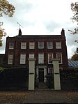 More images |
| Parnell House | Camden | Model Dwelling | 1849 | 14 May 1974 | TQ3000581476 51°31′02″N 0°07′40″W / 51.517254°N 0.127738°W / 51.517254; -0.127738 (Parnell House) | 1378865 |  More images |
| Philips Building, School of Oriental and African Studies | Camden | Library | 1970-3 | 20 May 2011 | TQ2988582061 51°31′21″N 0°07′45″W / 51.522539°N 0.129251°W / 51.522539; -0.129251 (Philips Building, School of Oriental and African Studies) | 1401342 |  More images |
| Powis House and attached railings | Camden | House | c. 1685 | 24 October 1951 | TQ3061881399 51°30′59″N 0°07′08″W / 51.516421°N 0.118937°W / 51.516421; -0.118937 (Powis House and attached railings) | 1379336 |  More images |
| Presbytery to Roman Catholic Italian Church of St Peter Roman Catholic Italian Church of St Peter | Camden | Priests House | 1862–1865 | 14 May 1974 | TQ3128682071 51°31′20″N 0°06′33″W / 51.522305°N 0.109066°W / 51.522305; -0.109066 (Presbytery to Roman Catholic Italian Church of St Peter Roman Catholic Italian Church of St Peter) | 1356763 |  More images |
| Primrose Hill Tunnels (eastern Portals) | Camden | Railway Tunnel Portal | 1837 Northern | 14 May 1974 | TQ2756684231 51°32′33″N 0°09′43″W / 51.542568°N 0.161873°W / 51.542568; -0.161873 (Primrose Hill Tunnels (eastern Portals)) | 1329904 |  More images |
| Princess Louise public house | Camden | Public House | 19th century | 15 January 1973 | TQ3043381491 51°31′02″N 0°07′18″W / 51.51729°N 0.121568°W / 51.51729; -0.121568 (Princess Louise public house) | 1378884 |  More images |
| Prudential Assurance Building | Camden | Office building | 1901 | 3 March 1972 | TQ3121481665 51°31′07″N 0°06′37″W / 51.518673°N 0.110254°W / 51.518673; -0.110254 (Prudential Assurance Building) | 1379064 |  More images |
| Rock House | Camden | House | Mid/Late 18th century | 10 June 1954 | TQ2833287359 51°34′14″N 0°08′59″W / 51.570505°N 0.149693°W / 51.570505; -0.149693 (Rock House) | 1139066 |  More images |
| Roman Catholic Church of St Mary | 4 Holly Walk, Hampstead | Roman Catholic Chapel | c. 1816 | 11 August 1950 | TQ2625085793 51°33′25″N 0°10′49″W / 51.556901°N 0.180279°W / 51.556901; -0.180279 (Roman Catholic Church of St Mary) | 1379106 |  More images |
| Roman Catholic Priory Church of St Dominic | Southampton Row, Belsize Park | Roman Catholic Church | 1874–1883 | 14 May 1974 | TQ2786485151 51°33′03″N 0°09′26″W / 51.550768°N 0.157244°W / 51.550768; -0.157244 (Roman Catholic Priory Church of St Dominic) | 1378775 |  More images |
| Russell Hotel and Attached Railings with Piers and Lamps | Camden | Gate Pier | 1892–1898 | 3 December 1970 | TQ3017882085 51°31′22″N 0°07′30″W / 51.522687°N 0.125022°W / 51.522687; -0.125022 (Russell Hotel and Attached Railings with Piers and Lamps) | 1246152 | 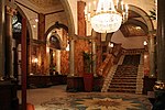 More images |
| Senate House, University of London (and formerly the Institute of Education) and Attached Railings | Camden | Gate | 1932–1938 | 28 March 1969 | TQ2992381896 51°31′16″N 0°07′44″W / 51.521047°N 0.128765°W / 51.521047; -0.128765 (Senate House, University of London (and formerly the Institute of Education) and Attached Railings) | 1113107 |  More images |
| Service Wing and Outbuildings to Kenwood House | Kenwood, Camden | Kitchen | 1793–1795 | 10 June 1954 | TQ2713087466 51°34′18″N 0°10′01″W / 51.571738°N 0.166988°W / 51.571738; -0.166988 (Service Wing and Outbuildings to Kenwood House) | 1379244 | 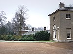 |
| Sham Bridge to South of Kenwood House | Kenwood, Camden | Balustrade | c. 1767 | 10 June 1954 | TQ2730887157 51°34′08″N 0°09′52″W / 51.568921°N 0.164533°W / 51.568921; -0.164533 (Sham Bridge to South of Kenwood House) | 1379245 | 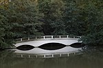 More images |
| Stanfield House and Attached Railings | 85 and 86, Hampstead High Street, Hampstead NW3 | House | 19th century | 11 August 1950 | TQ2654985619 51°33′19″N 0°10′34″W / 51.55527°N 0.176031°W / 51.55527; -0.176031 (Stanfield House and Attached Railings) | 1378695 |  More images |
| Statue of Charles James Fox | Camden | Statue | Completed 1814 | 24 October 1951 | TQ3031081710 51°31′09″N 0°07′24″W / 51.519286°N 0.123259°W / 51.519286; -0.123259 (Statue of Charles James Fox) | 1244458 |  More images |
| Sun House | Camden | House | 1935–1936 | 14 May 1974 | TQ2618185542 51°33′17″N 0°10′53″W / 51.554661°N 0.181364°W / 51.554661; -0.181364 (Sun House) | 1322140 |  More images |
| The Catacombs and Terrace in Highgate (western) Cemetery | Camden | Balustrade | c1838-1839 | 14 May 1974 | TQ2832387163 51°34′07″N 0°09′00″W / 51.568745°N 0.149894°W / 51.568745; -0.149894 (The Catacombs and Terrace in Highgate (western) Cemetery) | 1378923 |  More images |
| The Danish Church | Camden | Collegiate Chapel | 1826–1828 | 10 June 1954 | TQ2864783280 51°32′02″N 0°08′48″W / 51.533776°N 0.146641°W / 51.533776; -0.146641 (The Danish Church) | 1245872 | 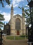 More images |
| The Hall and Attached Railings South Square | South Square, Gray's Inn, Holborn WC1 | Banqueting House | Earlier origins | 24 October 1951 | TQ3103781727 51°31′09″N 0°06′46″W / 51.519271°N 0.11278°W / 51.519271; -0.11278 (The Hall and Attached Railings South Square) | 1322154 |  More images |
| The Hill Garden Bridge | Inverforth Close, Hampstead NW3 | Arch Bridge | c. 1912 | 14 December 1978 | TQ2607386707 51°33′55″N 0°10′57″W / 51.565155°N 0.182504°W / 51.565155; -0.182504 (The Hill Garden Bridge) | 1113195 |  |
| The Hill Garden Central Temple Summerhouse | Inverforth Close, Hampstead NW3 | Balustrade | c. 1912 | 14 December 1978 | TQ2606586710 51°33′55″N 0°10′57″W / 51.565183°N 0.182618°W / 51.565183; -0.182618 (The Hill Garden Central Temple Summerhouse) | 1113199 |  |
| The Hill Garden Cruciform Pergola | Inverforth Close, Hampstead NW3 | Conservatory | c1906-1910 | 14 December 1978 | TQ2609686701 51°33′54″N 0°10′56″W / 51.565096°N 0.182174°W / 51.565096; -0.182174 (The Hill Garden Cruciform Pergola) | 1113202 |  |
| The Hill Garden Southern Pergola and Terrace | Inverforth Close, Hampstead NW3 | Belvedere | c1906-1910 | 14 December 1978 | TQ2610686626 51°33′52″N 0°10′55″W / 51.564419°N 0.182057°W / 51.564419; -0.182057 (The Hill Garden Southern Pergola and Terrace) | 1322065 | 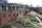 |
| The Hill Garden Southern Summerhouse | Inverforth Close, Hampstead NW3 | Garden Wall | c1906-1910 | 14 December 1978 | TQ2610786600 51°33′51″N 0°10′55″W / 51.564185°N 0.182052°W / 51.564185; -0.182052 (The Hill Garden Southern Summerhouse) | 1322067 |  |
| The Hill Garden Western Pergola | Inverforth Close, Hampstead NW3 | Balustrade | c. 1912 | 14 December 1978 | TQ2602486711 51°33′55″N 0°11′00″W / 51.565201°N 0.183209°W / 51.565201; -0.183209 (The Hill Garden Western Pergola) | 1322069 | Upload Photo |
| The Hill Garden Western Summerhouse | Inverforth Close, Hampstead NW3 | Balustrade | c. 1912 | 14 December 1978 | TQ2598386713 51°33′55″N 0°11′02″W / 51.565229°N 0.183799°W / 51.565229; -0.183799 (The Hill Garden Western Summerhouse) | 1322070 | Upload Photo |
| The Old Mansion and Attached Wall, Railings and Lamp Holder | 94 Frognal, Frognal NW3 | House | c. 1700 | 11 August 1950 | TQ2610285708 51°33′22″N 0°10′57″W / 51.55617°N 0.182444°W / 51.55617; -0.182444 (The Old Mansion and Attached Wall, Railings and Lamp Holder) | 1113070 |  More images |
| The Roundhouse | Chalk Farm Road, Chalk Farm NW1 | Warehouse | 1860s | 10 June 1954 | TQ2829784302 51°32′35″N 0°09′05″W / 51.54304°N 0.151312°W / 51.54304; -0.151312 (The Roundhouse) | 1258103 |  More images |
| Tomb of John Constable and Family and Attached Railings in St John-at-Hampstead Churchyard | Churchyard of St John-at-Hampstead, Church Row, Hampstead NW3 | Family Vault | 1828 | 14 May 1974 | TQ2623985558 51°33′17″N 0°10′50″W / 51.554792°N 0.180522°W / 51.554792; -0.180522 (Tomb of John Constable and Family and Attached Railings in St John-at-Hampstead Churchyard) | 1067357 |  More images |
| Tomb of Marthe Goscombe John and Sir William Goscombe John in Hampstead Cemetery | Camden | Gravestone | c. 1923 | 11 January 1999 | TQ2487385604 51°33′20″N 0°12′01″W / 51.555509°N 0.200199°W / 51.555509; -0.200199 (Tomb of Marthe Goscombe John and Sir William Goscombe John in Hampstead Cemetery) | 1322159 |  |
| Tomb of William and John Hart and R Carey and a Cary in St Johns Churchyard | Camden | Family Vault | c. 1717 | 11 January 1999 | TQ2621285596 51°33′19″N 0°10′51″W / 51.555139°N 0.180898°W / 51.555139; -0.180898 (Tomb of William and John Hart and R Carey and a Cary in St Johns Churchyard) | 1067367 |  |
| Voel House | 18, South Grove, Highgate N6 | House | Late C16/Early 17th century | 10 June 1954 | TQ2824587200 51°34′09″N 0°09′04″W / 51.569096°N 0.151005°W / 51.569096; -0.151005 (Voel House) | 1378764 |  |
| British Medical Association War Memorial | British Medical Association House, Tavistock Square WC1H | Steps | 1954 | 15 April 1998 | TQ2993182463 51°31′34″N 0°07′42″W / 51.526141°N 0.128441°W / 51.526141; -0.128441 (British Medical Association War Memorial) | 1378969 |  More images |
| Witanhurst | 41, Highgate West Hill, Highgate N6 | House | Early 18th century | 16 December 1970 | TQ2811787189 51°34′08″N 0°09′10″W / 51.569026°N 0.152855°W / 51.569026; -0.152855 (Witanhurst) | 1379026 | 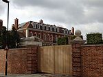 More images |
| 1 Elm Row | 1 Elm Row, Hampstead NW3 | House | 1720 | 11 August 1950 | TQ2639186057 51°33′33″N 0°10′41″W / 51.559242°N 0.178152°W / 51.559242; -0.178152 (1 Elm Row) | 1078275 |  |
| 33, 34, and 35 Great Queen Street | Great Queen Street, Covent Garden | Terraced House | c. 1710 | 24 October 1951 | TQ3042781263 51°30′55″N 0°07′18″W / 51.515242°N 0.121739°W / 51.515242; -0.121739 (33, 34, and 35 Great Queen Street) | 1113215 |  |
| 27, 28, and 29 Great Queen Street | Great Queen Street, Covent Garden | Terrace | c. 1733 | 24 October 1951 | TQ3044681292 51°30′56″N 0°07′17″W / 51.515499°N 0.121454°W / 51.515499; -0.121454 (27, 28, and 29 Great Queen Street) | 1113213 |  |
| 60 Carey Street | Camden | House | Early 18th century | 24 October 1951 | TQ3106981276 51°30′55″N 0°06′45″W / 51.515211°N 0.112487°W / 51.515211; -0.112487 (60 Carey Street) | 1244098 |  More images |
| 2–16 Dukes Street | Camden | House | 1822 | 10 June 1954 | TQ2987182550 51°31′37″N 0°07′45″W / 51.526936°N 0.129273°W / 51.526936; -0.129273 (2–16 Dukes Street) | 1342088 | 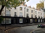 |
| 1–12 Holly Village | Camden | Estate Cottage | 1865 | 10 June 1954 | TQ2858886501 51°33′46″N 0°08′47″W / 51.562736°N 0.146315°W / 51.562736; -0.146315 (1–12 Holly Village) | 1379116 |  More images |
| 46 Lambs Conduit Street | Camden | House | 1720 | 14 May 1974 | TQ3062181999 51°31′19″N 0°07′07″W / 51.521812°N 0.118672°W / 51.521812; -0.118672 (46 Lambs Conduit Street) | 1379271 |  |
| 5 Church Row | 5 Church Row, Hampstead NW3 | House | 1728 | 11 August 1950 | TQ2631285657 51°33′20″N 0°10′46″W / 51.555665°N 0.179434°W / 51.555665; -0.179434 (5 Church Row) | 1067340 | 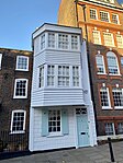 |
| 81 Swains Lane | 81 Swains Lane, Highgate N6 | House | 1967–1969 | 10 August 2009 | TQ2854586925 51°34′00″N 0°08′48″W / 51.566556°N 0.14678°W / 51.566556; -0.14678 (81 Swains Lane) | 1393411 | 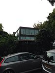 More images |
| 1, 2, and 3 Willow Road | Camden | Terrace Houses | 1938 | 14 May 1974 | TQ2701985841 51°33′26″N 0°10′09″W / 51.55716°N 0.169176°W / 51.55716; -0.169176 (1, 2, and 3 Willow Road) | 1379196 |  More images |
| 66 Frognal | Camden | House | 1937–1938 | 1 August 1973 | TQ2610385548 51°33′17″N 0°10′57″W / 51.554732°N 0.182487°W / 51.554732; -0.182487 (66 Frognal) | 1113062 |  More images |
| 2 and 4 Redington Road | 2 and 4 Redington Road, Hampstead NW3 | Semi Detached House | 1876 | 25 January 1963 | TQ2601085712 51°33′22″N 0°11′02″W / 51.556227°N 0.183769°W / 51.556227; -0.183769 (2 and 4 Redington Road) | 1245497 |  |
| 57 and 58 Lincoln Inns Field | Camden | House | c. 1730 | 24 October 1951 | TQ3065781323 51°30′57″N 0°07′06″W / 51.515729°N 0.118404°W / 51.515729; -0.118404 (57 and 58 Lincoln Inns Field) | 1379332 |  More images |
| 65 Lincolns Inn Fields | Camden | House | 1772 | 24 October 1951 | TQ3062281385 51°30′59″N 0°07′08″W / 51.516294°N 0.118885°W / 51.516294; -0.118885 (65 Lincolns Inn Fields) | 1379335 |  More images |
| 4–18 and 4a–18a Woburn Walk | Camden | Terrace House | 1822 | 10 June 1954 | TQ2988882520 51°31′36″N 0°07′45″W / 51.526663°N 0.129039°W / 51.526663; -0.129039 (4–18 and 4a–18a Woburn Walk) | 1379210 | 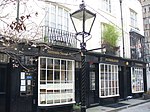 |
| 1–9 and 1a–9a Woburn Walk | 1–9 and 1a–9a Woburn Walk, WC1H | Terrace House | 1822 | 10 June 1954 | TQ2987082530 51°31′36″N 0°07′45″W / 51.526757°N 0.129295°W / 51.526757; -0.129295 (1–9 and 1a–9a Woburn Walk) | 1379209 |  |
| Hopkins House | 49a Downshire Hill, Hampstead NW3 | House | 1976 | 4 June 2018 | TQ2692085622 51°33′19″N 0°10′14″W / 51.555214°N 0.17068190°W / 51.555214; -0.17068190 (Hopkins House) | 1444039 |  More images |
See also
Notes
- ^ The date given is the date used by Historic England as significant for the initial building or that of an important part in the structure's description.
- ^ Sometimes known as OSGB36, the grid reference is based on the British national grid reference system used by the Ordnance Survey.
- ^ The "List Entry Number" is a unique number assigned to each listed building and scheduled monument by Historic England.
External links
 Media related to Grade II* listed buildings in the London Borough of Camden at Wikimedia Commons
- v
- t
- e
- Bloomsbury
- Camden Town
- Chalk Farm and Haverstock ward
- Fortune Green
- Gospel Oak
- Hampstead (inc. Belsize Park, Frognal, Finchley Road, South Hampstead and Swiss Cottage)
- Hatton Garden (inc. Saffron Hill)
- Kentish Town
- Primrose Hill
- Regent's Park Estate
- St Giles
- St Pancras
- Somers Town
- West Hampstead
| Partly in Camden |
|
|---|

- Ben Uri Gallery & Museum
- Bloomsbury Theatre
- British Library
- British Museum
- Brunswick Centre
- BT Tower
- Camden Arts Centre
- Charles Dickens Museum
- Dominion Theatre
- Donmar Warehouse
- Fenton House
- Foundling Museum
- Freud Museum
- Highgate Cemetery
- Keats House
- Kenwood House
- The Jewish Museum
- O2 Forum Kentish Town
- Petrie Museum of Egyptian Archaeology
- Roundhouse
- Shaftesbury Theatre
- Sir John Soane's Museum
- Wellcome Collection
- West End theatre
open spaces
- Hampstead and Kilburn
- Holborn and St Pancras
rail stations
 Belsize Park
 Camden Road
- Camden Town
- Chalk Farm
- Chancery Lane
 Euston
- Euston tube
- Euston Square
- Finchley Road
- Finchley Road & Frognal
- Goodge Street
- Gospel Oak
- Hampstead
- Hampstead Heath
- Holborn
- Kentish Town
- Kentish Town West
- Kilburn High Road
- King's Cross
- King's Cross St Pancras
- Mornington Crescent
- Russell Square
- St Pancras
- South Hampstead
- Swiss Cottage
- Tottenham Court Road
- Warren Street
- West Hampstead
- West Hampstead (Overground)
- West Hampstead Thameslink


- Blue plaques
- Coat of arms
- Council
- Listed buildings
- Grade I
- Grade II*
- People
- Public art
- Schools
 Category
- Commons

Portals:
 London
 Architecture


