London Borough of Bexley
| London Borough of Bexley | ||
| Borough | ||
 | ||
| ||
| Motto: Boldly And Rightly (engelska: Djärvt och riktigt) | ||
| Land |  Storbritannien Storbritannien | |
|---|---|---|
| Riksdel |  England England | |
| Region | London | |
| Läge | 51°25′00″N 0°08′00″Ö / 51.416667°N 0.133333°Ö / 51.416667; 0.133333 | |
| Area | 61 km²[1] | |
| Folkmängd | 228 000 (2010) | |
| Befolkningstäthet | 3 738 invånare/km² | |
| Geonames | 3333124 | |
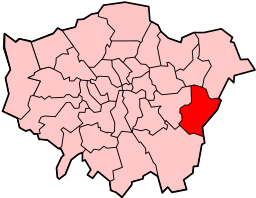 Bexleys läge i Storlondon. | ||
| Webbplats: www.bexley.gov.uk | ||
London Borough of Bexley är en borough i sydöstra London. 228 000 invånare (beräknat värde, 2010). Den bildades 1965 när Borough of Bexley, Borough of Erith, Crayford Urban District och delar av Chislehurst and Sidcup Urban District slogs samman.
Distrikt
Distrikt som helt eller delvis ligger i Bexley:
- Barnes Cray
- Belvedere
- Bexley
- Bexleyheath (även Bexley New Town)
- Blackfen
- Barnehurst
- Colyers
- Crook Log
- Crayford
- Erith
- Foots Cray
- Falconwood
- Longlands
- Northumberland Heath
- North End
- Ruxley
- Slade Green
- Sidcup
- Thamesmead
- Upton
- Welling
- West Heath
Externa länkar
 Wikimedia Commons har media som rör London Borough of Bexley.Bilder & media
- Bexleys councils officiella webbplats
| |||||||||||
- ^ ”Standard Area Measurements for Administrative Areas (December 2023) in the UK” (på engelska) (zip). Office for National Statistics. 31 maj 2024. https://geoportal.statistics.gov.uk/datasets/ons::standard-area-measurements-for-administrative-areas-december-2023-in-the-uk/about. Läst 7 juni 2024.


