Majdal Yaba
Majdal Yaba مجدل يابا Majdal al-Sadiq, Majdal Yafa | |
|---|---|
Desa | |
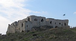 Benteng Menara Majdal di bekas situs Majdal Yaba, 2008 | |
| 32°04′51.04″N 34°57′24.97″E / 32.0808444°N 34.9569361°E / 32.0808444; 34.9569361Koordinat: 32°04′51.04″N 34°57′24.97″E / 32.0808444°N 34.9569361°E / 32.0808444; 34.9569361 | |
| Grid Palestina | 146/165 |
| Entitas geopolitik | Mandat Palestina |
| Subdistrik | Ramle |
| Tanggal pengosongan | 10 Juli 1948[3] |
| Luas | |
| • Total | 26,332 dunams (26,332 km2 or 10,167 sq mi) |
| Populasi (1945) | |
| • Total | 1.520[1][2] |
| Sebab pengosongan | Serangan militer oleh pasukan Yishuv |
| Wilayah saat ini | Rosh HaAyin, Givat HaShlosha, Nahshonim,[4] Migdal Afek[5] |
Majdal Yaba (bahasa Arab: مجدل يابا) adalah sebuah desa Arab Palestina di Subdistrik Ramle, yang berjarak 185 kilometer (115 mi) dari timur laut Ramla dan 4 kilometer (2,5 mi) dari timur Jaffa. Sebuah kota bertembok berdiri di situs yang sama pada awal 3000 SM, dan Majdal Yaba mula-mula disebut dengan nama Aphek dalam naskah-naskah Eksekrasi Mesir dari abad ke-19 SM.
Referensi
- ^ a b Kesalahan pengutipan: Tag
<ref>tidak sah; tidak ditemukan teks untuk ref bernamaHadawi67 - ^ Government of Palestine, Department of Statistics, 1945, p. 30
- ^ Morris, 2004, p. xviii, village #388. Also gives cause of depopulation.
- ^ Morris, 2004, p. xxii, settlement #99
- ^ Morris, 2004, p. xxii, settlement #100
Daftar pustaka
- Barron, J.B., ed. (1923). Palestine: Report and General Abstracts of the Census of 1922. Government of Palestine.
- Bourrienne, L.A.F. de (1891). Memoirs of Napoleon Bonaparte. 1. Charles Scribners Sons. ISBN 978-1-4446-7930-4.
- Clermont-Ganneau, C.S. (1896). [ARP] Archaeological Researches in Palestine 1873-1874, translated from the French by J. McFarlane. 2. London: Palestine Exploration Fund. (pp. 340-341)
- Conder, C.R.; Kitchener, H.H. (1882). The Survey of Western Palestine: Memoirs of the Topography, Orography, Hydrography, and Archaeology. 2. London: Committee of the Palestine Exploration Fund.
- Conder, C.R. (1897). The Latin Kingdom of Jerusalem, 1099 to 1291 AD. London: Committee of the Palestine Exploration Fund.
- Doguereau, J.-P. (2002). Guns in the Desert. Praeger. ISBN 0-313-32512-X.
- Doumani, B. (1995). Rediscovering Palestine: Merchants and Peasants in Jabal Nablus, 1700-1900. University of California Press. ISBN 0-520-20370-4.
- Finn, J. (1877). Byeways in Palestine. London: James Nisbet.
- Gil, M. (1997). A History of Palestine, 634 - 1099. University of Cambridge Press. ISBN 978-0-521-59984-9.
- Government of Palestine, Department of Statistics (1945). Village Statistics, April, 1945.
- Guérin, V. (1875). Description Géographique Historique et Archéologique de la Palestine (dalam bahasa French). 2: Samarie, pt. 2. Paris: L'Imprimerie Nationale. Pemeliharaan CS1: Bahasa yang tidak diketahui (link)
- Hadawi, S. (1970). Village Statistics of 1945: A Classification of Land and Area ownership in Palestine. Palestine Liberation Organization Research Center.
- Hütteroth, Wolf-Dieter; Abdulfattah, Kamal (1977). Historical Geography of Palestine, Transjordan and Southern Syria in the Late 16th Century. Erlanger Geographische Arbeiten, Sonderband 5. Erlangen, Germany: Vorstand der Fränkischen Geographischen Gesellschaft. ISBN 3-920405-41-2.
- Khalidi, W. (1992). All That Remains: The Palestinian Villages Occupied and Depopulated by Israel in 1948. Washington D.C.: Institute for Palestine Studies. ISBN 0-88728-224-5.
- Laughlin, John Charles Hugh (2006). Fifty Major Cities of the Bible: From Dan to Beersheba. Taylor & Francis. ISBN 978-0-415-22315-7.
- Le Strange, G. (1890). Palestine Under the Moslems: A Description of Syria and the Holy Land from A.D. 650 to 1500. London: Committee of the Palestine Exploration Fund.
- Mills, E., ed. (1932). Census of Palestine 1931. Population of Villages, Towns and Administrative Areas. Jerusalem: Government of Palestine.
- Morris, B. (2004). The Birth of the Palestinian Refugee Problem Revisited. Cambridge University Press. ISBN 0-521-00967-7.
- Murphy-O'Connor, Jeremiah (2008). The Holy Land: An Oxford Archaeological Guide from Earliest Times to 1700. Oxford University Press US. ISBN 978-0-19-923666-4.
- Palmer, E.H. (1881). The Survey of Western Palestine: Arabic and English Name Lists Collected During the Survey by Lieutenants Conder and Kitchener, R. E. Transliterated and Explained by E.H. Palmer. Committee of the Palestine Exploration Fund.
- Petersen, Andrew (2001). A Gazetteer of Buildings in Muslim Palestine (British Academy Monographs in Archaeology). 1. Oxford University Press. ISBN 978-0-19-727011-0. (pp. 213–215.)
- Pringle, Denys (1997). Secular buildings in the Crusader Kingdom of Jerusalem: an archaeological Gazetter. Cambridge University Press. ISBN 0521 46010 7.
- Pringle, Denys (1998). The Churches of the Crusader Kingdom of Jerusalem: L-Z (excluding Tyre). II. Cambridge University Press. ISBN 0 521 39037 0.
- Rey, E.G. (1883). Les colonies franques de Syrie aux XIIme et XIIIme siècles (dalam bahasa French). Paris: A. Picard. Pemeliharaan CS1: Bahasa yang tidak diketahui (link) (pp. 412-413)
- Robinson, E.; Smith, E. (1856). Later Biblical Researches in Palestine and adjacent regions: A Journal of Travels in the year 1852. London: John Murray.
- Röhricht, R. (1893). (RRH) Regesta regni Hierosolymitani (MXCVII-MCCXCI) (dalam bahasa Latin). Berlin: Libraria Academica Wageriana.
- Schölch, Alexander (1986): Palästina im Umbruch 1856-1882. Wiesbaden and Stuttgart: Franz Steiner Verlag.
- Schölch, Alexander (1993). Palestine in Transformation, 1856-1882: Studies in Social, Economic, and Political Development. Institute for Palestine Studies. ISBN 0-88728-234-2.
- van de Velde, C.W.M. (1858). Memoir to Accompany the Map of the Holy Land. Gotha: Justus Perthes.
Pranala luar
- Welcome To Majdal Yaba
- Majdal Yaba\ al-Sadiq, Zochrot
- Survey of Western Palestine, Map 14: IAA, Wikimedia commons


