County Baltimore, Maryland

Baltimore County, Maryland
Baltimore County Courthouse
Flag of Baltimore County, Maryland
Bendera
Seal of Baltimore County, Maryland
Seal
Map of Maryland highlighting Baltimore County
Lokasi di negara bagian Maryland
Map of the United States highlighting Maryland
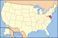
Lokasi negara bagian Maryland di Amerika Serikat
Didirikan1659
Asal namaCecil Calvert, Baron Baltimore
SeatTowson
Wilayah
 • Keseluruhan68.203 sq mi (176.645 km2)
 • Daratan59.859 sq mi (155.034 km2)
 • Perairan8.344 sq mi (21.611 km2), 12.23%
Populasi
 • (2010)805.029
 • Kepadatan1.345/sq mi (519,3/km²)
Distrik kongress1st, 2nd, 3rd, 7th
Zona waktuTimur:
UTC-5 (EST) / -4 (EDT)
Situs webwww.baltimorecountymd.gov

Koordinat: 39°24′N 76°36′W / 39.400°N 76.600°W / 39.400; -76.600

Baltimore County adalah county yang terletak di bagian utara Negara Bagian Maryland. Berdasarkan Sensus 2010, jumlah penduduk di county ini mencapai 805,029 jiwa.[1] County seat dari county ini berada di Towson.[2] Nama County ini diambil dari Kebaronan dari Proprietari Koloni Maryland, Cæcilius Calvert, Baron Baltimore, dan Kota "Baltimore" di County Longford, Irlandia.

Referensi

  1. ^ "State & County QuickFacts". United States Census Bureau. Diarsipkan dari versi asli tanggal 2011-07-06. Diakses tanggal August 20, 2013. 
  2. ^ "Find a County". National Association of Counties. Diakses tanggal 2011-06-07. 
  • l
  • b
  • s
 Negara bagian Maryland
Annapolis (ibu kota)
Topik
  • Cities
  • Government
  • History
  • People
  • Congressional Delegations
  • Congressional Maps
  • Economy
  • List of Maryland-related topics
  • Visitor Attractions
Wilayah
  • Allegheny Mountains
  • Atlantic Coastal Plain
  • Baltimore‑Washington Metro Area
  • Blue Ridge
  • Chesapeake
  • Cumberland Valley
  • Delaware Valley
  • Delmarva Peninsula
  • Eastern Shore
  • Piedmont
  • Ridge and Valley
  • Southern Maryland
  • Western Maryland
  • Western Shore
Kota besar
Kota sensus
  • Adelphi
  • Arbutus
  • Arnold
  • Aspen Hill
  • Ballenger Creek
  • Bel Air North
  • Bel Air South
  • Bethesda
  • Brooklyn Park
  • Calverton
  • Camp Springs
  • Carney
  • Catonsville
  • Chesapeake Ranch Estates-Drum Point
  • Chillum
  • Clinton
  • Cockeysville-Hunt Valley
  • Colesville
  • Columbia
  • Coral Hills
  • Crofton
  • Damascus
  • Dundalk
  • East Riverdale
  • Edgewood
  • Eldersburg
  • Elkridge
  • Ellicott City
  • Essex
  • Fairland
  • Ferndale
  • Forestville
  • Fort Washington
  • Friendly
  • Germantown
  • Glen Burnie
  • Glenn Dale
  • Greater Landover
  • Greater Upper Marlboro
  • Green Haven
  • Green Valley
  • Halfway
  • Hillcrest Heights
  • Joppatowne
  • Kettering
  • Lake Shore
  • Langley Park
  • Lanham-Seabrook
  • Lansdowne-Baltimore Highlands
  • Lexington Park
  • Linganore-Bartonsville
  • Lochearn
  • Lutherville-Timonium
  • Mays Chapel
  • Middle River
  • Milford Mill
  • Montgomery Village
  • North Bethesda
  • North Laurel
  • North Potomac
  • Ocean Pines
  • Odenton
  • Olney
  • Overlea
  • Owings Mills
  • Oxon Hill-Glassmanor
  • Parkville
  • Parole
  • Pasadena
  • Perry Hall
  • Pikesville
  • Potomac
  • Randallstown
  • Redland
  • Reisterstown
  • Riviera Beach
  • Rosaryville
  • Rosedale
  • Rossville
  • St. Charles
  • Savage-Guilford
  • Severn
  • Severna Park
  • Silver Spring
  • South Gate
  • South Laurel
  • Suitland-Silver Hill
  • Towson
  • Waldorf
  • Walker Mill
  • Wheaton-Glenmont
  • White Oak
  • Woodlawn
County


Artikel bertopik Amerika Serikat ini adalah sebuah rintisan. Anda dapat membantu Wikipedia dengan mengembangkannya.

  • l
  • b
  • s