Barbara, Gaza
Barbara برْبره Berbere | |
|---|---|
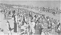 Sebuah balap kuda yang diadakan di Barbara, Palestine, 7 September 1940, dengan ditonton oleh pasukan Divisi ke-6 Australia. | |
| 31°37′26″N 34°34′46″E / 31.62389°N 34.57944°E / 31.62389; 34.57944Koordinat: 31°37′26″N 34°34′46″E / 31.62389°N 34.57944°E / 31.62389; 34.57944 | |
| Grid Palestina | 110/114 |
| Entitas geopolitik | Mandat Palestina |
| Subdistrik | Gaza |
| Tanggal pengosongan | 5 November 1948[3] |
| Luas | |
| • Total | 13,978 dunams (13,978 km2 or 5,397 sq mi) |
| Populasi (1945) | |
| • Total | 2,410[1][2] |
| Sebab pengosongan | Serangan militer oleh pasukan Yishuv |
| Wilayah saat ini | Mavki'im,[4][5] Talmei Yafeh[5] |
Barbara (bahasa Arab: برْبره) adalah sebuah desa Arab Palestina di Subdistrik Gaza yang berjarak 17 km dari timur laut kota Gaza, berdekatan dengan wilayah modern Ashkelon. Desa tersebut memiliki populasi 2.410 pada 1945.
Referensi
- ^ a b Government of Palestine, Department of Statistics. Village Statistics, April, 1945. Quoted in Hadawi, 1970, p. 45
- ^ Department of Statistics, 1945, p. 31 Diarsipkan 14 April 2020 di Wayback Machine.
- ^ Morris, 2004, p. xvii, village #310. Also gives the cause for depopulation
- ^ Morris, 2004, p. xxi: settlement #50, January 1949.
- ^ a b Khalidi, 1992, p. 82
Daftar pustaka
- Barron, J.B., ed. (1923). Palestine: Report and General Abstracts of the Census of 1922. Government of Palestine.
- Conder, C.R.; Kitchener, H.H. (1883). The Survey of Western Palestine: Memoirs of the Topography, Orography, Hydrography, and Archaeology. 3. London: Committee of the Palestine Exploration Fund.
- Dauphin, Claudine (1998). La Palestine byzantine, Peuplement et Populations. BAR International Series 726 (dalam bahasa French). III : Catalogue. Oxford: Archeopress. ISBN 0-860549-05-4. Pemeliharaan CS1: Bahasa yang tidak diketahui (link) (p. 876 )
- Department of Statistics (1945). Village Statistics, April, 1945. Government of Palestine.
- Guérin, V. (1869). Description Géographique Historique et Archéologique de la Palestine (dalam bahasa French). 1: Judee, pt. 2. Paris: L'Imprimerie Nationale. Pemeliharaan CS1: Bahasa yang tidak diketahui (link)
- Hadawi, S. (1970). Village Statistics of 1945: A Classification of Land and Area ownership in Palestine. Palestine Liberation Organization Research Center.
- Haimi, Yoram (2008-04-02). "Mavqi'im Final Report" (120). Hadashot Arkheologiyot – Excavations and Surveys in Israel.
- Haimi, Yoram (2016-11-15). "Horbat Barbarit" (128). Hadashot Arkheologiyot – Excavations and Surveys in Israel.
- Hartmann, M. (1883). "Die Ortschaftenliste des Liwa Jerusalem in dem türkischen Staatskalender für Syrien auf das Jahr 1288 der Flucht (1871)". Zeitschrift des Deutschen Palästina-Vereins. 6: 102–149.
- Hütteroth, Wolf-Dieter; Abdulfattah, Kamal (1977). Historical Geography of Palestine, Transjordan and Southern Syria in the Late 16th Century. Erlanger Geographische Arbeiten, Sonderband 5. Erlangen, Germany: Vorstand der Fränkischen Geographischen Gesellschaft. ISBN 3-920405-41-2.
- Karmon, Y. (1960). "An Analysis of Jacotin's Map of Palestine" (PDF). Israel Exploration Journal. 10 (3,4): 155–173; 244–253. Diarsipkan dari versi asli (PDF) tanggal 2019-12-22. Diakses tanggal 2020-07-26.
- Khalidi, W. (1992). All That Remains: The Palestinian Villages Occupied and Depopulated by Israel in 1948. Washington D.C.: Institute for Palestine Studies. ISBN 0-88728-224-5.
- Mills, E., ed. (1932). Census of Palestine 1931. Population of Villages, Towns and Administrative Areas. Jerusalem: Government of Palestine.
- Morris, B. (2004). The Birth of the Palestinian Refugee Problem Revisited. Cambridge University Press. ISBN 978-0-521-00967-6.
- Nikolsky, Vlada (2013-02-17). "Horbat Barbarit" (125). Hadashot Arkheologiyot – Excavations and Surveys in Israel.
- Palmer, E.H. (1881). The Survey of Western Palestine: Arabic and English Name Lists Collected During the Survey by Lieutenants Conder and Kitchener, R. E. Transliterated and Explained by E.H. Palmer. Committee of the Palestine Exploration Fund.
- Robinson, E.; Smith, E. (1841). Biblical Researches in Palestine, Mount Sinai and Arabia Petraea: A Journal of Travels in the year 1838. 3. Boston: Crocker & Brewster.
- Socin, A. (1879). "Alphabetisches Verzeichniss von Ortschaften des Paschalik Jerusalem". Zeitschrift des Deutschen Palästina-Vereins. 2: 135–163.
Pranala luar
- Welcome to Barbara Palestine Remembered
- Barbara, Zochrot
- Survey of Western Palestine, Map 20: IAA, Wikimedia commons
- Barbara, from the Khalil Sakakini Cultural Center


