Zuqaq al-Blat
Quarter of Beirut
33°53′32″N 35°29′54″E / 33.89222°N 35.49833°E / 33.89222; 35.49833
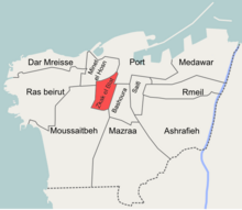
Zuqaq al-Blat (Arabic: زقاق البلاط) is one of the twelve quarters of Beirut.[1]
Etymology
Zoqaq al-Blat literally means "the cobbled alley", this was a colloquial name given to the street extending from the old city to the Qantari hill and which was covered with cobblestones in the 19th century.[2]
Zuqaq al-Blat is also commonly called "al-Batrakieh" (Arabic: البطركية, the Patriarchate) due to the presence of the seat of the Greek Catholic Patriarchate of Beirut within its borders.[3]
History
Once a medieval walled port town, Beirut experienced rapid growth during the second half of the 19th century; the overcrowded city developed beyond its walls and the affluent citizens started to build their villas on the slopes of the surrounding hills, namely Ashrafieh, Qnatari and Musaytbeh.[4][5]
In 1832 Beirut came under the occupation of Ibrahim Pasha's troops. The new Egyptian authorities undertook grand works of urban planning and sanitation. The appointed Egyptian-Circassian governor of Beirut, Mahmoud Naami Bey commissioned street cobbling works which stretched beyond the city's walls, the street extending from the south-western side of the city wall into the new extramural neighborhoods on the Qantari hill came to be known as Zoqaq al-Blat and gave its name to the quarter.[2]
Notable residents
Some of the notable people resided in Zuqaq al-Blat included:
References
- ^ Hanssen, Jens (2005). Fin de Siècle Beirut: The Making of an Ottoman Provincial Capital. Oxford University Press. ISBN 0199281637. Archived from the original on 2023-08-17. Retrieved 2020-10-04.
- ^ a b Kassir, Samir (2006). تاريخ بيروت (in Arabic). Beirut: Dar An-Nahar. ISBN 9953741018.
- ^ زقاق البلاط (in Arabic). yabeyrouth.com. Archived from the original on October 22, 2012. Retrieved February 14, 2013.
- ^ Kihtir Öztürk, Pelin (September 2006). Urban transformation of Ottoman port cities in the nineteenth century: Change from Ottoman Beirut to French mandatory Beirut (PDF) (MA thesis). Middle East Technical University. Archived (PDF) from the original on 2014-02-02. Retrieved 2013-02-14.
- ^ Kassir, Samir; M. B. DeBevoise (2010). Beirut. University of California Press. ISBN 978-0520256682.
- ^ a b c d Speidl, Bianka (2011). "Distance in vicinity: Beirut's Zuqaq el-Blat, a place of transformation, conflict and co-existence". Études sur la Région Méditerranéenne. 20: 37. Archived from the original on 2023-04-29. Retrieved 2023-04-29.
- v
- t
- e
Beirut Neighbourhoods (a.k.a. cadastres, quarters), Numbered Sectors, and Streets
- 35 Ras Beirut sector in Dar el-Mraisse
- 34 Hamra (Hamra Street شارع الحمراء)
- 36 Manara
- 37 Qoreitem
- 38 Raouché الروشة (Rue Madame Curie شارع مدام كوري)
- 39 Ain el-Tineh
- Avenue des Français
- Corniche Beirut كورنيش (Avenue de Paris, Avenue General de Gaulle شارع الجنرال ديغول)
- Rue Bliss شارع بلس
- Rue Clemenceau شارع كليمنصو
- Rue George Post
- Rue Jeanne d'Arc
- Rue John Kennedy
- Rue de Phénicie
- Rue Spears
- Rue Van Dyck
- 40 Zarif
- 41 Sanyeh
- 42 Talle el-Drouz
- 44 Dar el-Fatwa
- 45 Tallet el-Khayat
- 46 UNESCO
- 47 Mar Elias
- 48 Wata
- 49 Mousaitbeh sector
- 23 Serail
- 24 Batrakieh
- 20 Mina el-Hosn
- 21 Bab Idris
- 22 Qantari
- 11 Nejmeh
- 12 Majidieh
- 14 Marfa'a
- 15 BEIRUT CENTRAL DISTRICT وسط بيروت (Saint George Bay - Foch-Allenby - Serail Hill- Nejmeh Square-Rue Maarad شارع المعرض - Rue Verdun - Rue Weygand (Rue Nouvelle) - Beirut Souks - Wadi Abu Jamil)
- 25 Basta el-Tahta
- 26 Bachoura sector
- 50 Burj Abi Haidar
- 51 Basta el-Faouqa
- 52 Ras el-Nabaa
- 53 Mazraa sector
- 55 Malaab
- 56 Tariq el-Jdideh
- 57 Horch
- 58 Parc
- 59 Amlieh
- Rue Huvelin
- Sassine Square
- 61 Furn el-Hayek
- 62 Nasra
- 63 Achrafieh sector
- 64 Hôtel Dieu
- 65 Mar Mitr
- 66 Adlieh (Palais de Justice)
- 67 Sioufi
- 68 Ghabi
- 69 Croniche el-Nahr
- Sodeco (Rue Monnot شارع مونو)
- 27 Yesouieh
- 28 Mar Maroun
- 29 Gemmayzeh sector in Saifi
- Gemmayzeh جميزة/Mar Nicolas مار نقولا (Escalier de l'Art - Rue Gouraud - Rue Sursock)
- 73 Hikmeh
- 74 Mustashfa El-Roum (Hôpital Orthodoxe)
- 78 Jeitaoui
- 79 Qobayat
- Badaro
- 72 Rmeil sector of Medawar neighbourhood
- 75 Mar Mikhaël
- 76 Khodr
- 77 Jisr
Authority control databases | |
|---|---|
| International |
|
| National |
|


