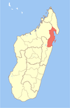
Vavatenina District
Place in Analanjirofo, Madagascar
17°31′S 48°57′E / 17.517°S 48.950°E / -17.517; 48.950 Madagascar
 (2020)
518
Vavatenina District is a district of northeast Madagascar. It is part of the Analanjirofo Region. The district has an area of 2,671 km2 (1,031 sq mi), and the estimated population in 2020 was 202,529.[2]
Communes
The district is further divided into 11 communes:
- Ambatoharanana
- Ambodimangavalo
- Ambohibe
- Ampasimazava
- Andasibe
- Anjahambe
- Maromitety
- Miarinarivo
- Sahatavy
- Tanamarina
- Vavatenina
Rivers
The main river is the Maningory River.
Roads
The capital of the district, Vavatenina is situated at 45 km from Fénérive-Est, by the National Road 5 and National Road 22.[3]
Economy
The region is one of the most important clove growing areas of Madagascar.
References
- ^ Estimated based on DEM data from Shuttle Radar Topography Mission
- ^ "Ambatondrazaka (District, Madagascar) - Population Statistics, Charts, Map and Location". www.citypopulation.de. Retrieved 2024-01-17.
- ^ Cartographie District Vavatenina
- v
- t
- e
Capital: Fenoarivo Atsinanana

6 districts; 71 communes
 | This Analanjirofo location article is a stub. You can help Wikipedia by expanding it. |
- v
- t
- e


