$14 billion (2018 USD) (Third-costliest typhoon on record in nominal terms)
Areas affected
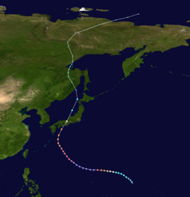
Northern Mariana Islands, Taiwan, Japan, Russian Far East
IBTrACS
Part of the 2018 Pacific typhoon season
Typhoon Jebi, known in the Philippines as Super Typhoon Maymay, was the costliest typhoon in Japan's history in terms of insured losses. Jebi formed from a tropical disturbance south-southwest of Wake Island on August 26 and became the twenty-first named storm of the 2018 Pacific typhoon season on August 27. Amid favorable environmental conditions, Jebi quickly strengthened into a typhoon on August 29 as it headed west and rapidly intensified as it passed the Northern Mariana Islands on August 30. Jebi reached its peak intensity as a Category 5-equivalent typhoon on August 31, with 10-minute sustained winds of 195 km/h (120 mph), 1-minute sustained winds of 285 km/h (180 mph), and a minimum pressure of 915 hPa (mbar; 27.02 inHg). Afterwards, Jebi began a slow weakening trend as it turned northwest, briefly passing through the Philippine Area of Responsibility on September 2. Jebi accelerated north-northeast towards Japan on September 3 as it interacted with the westerlies, and made landfalls over Shikoku and near Kobe early on September 4. Jebi quickly weakened over land and became an extratropical cyclone later that day over the Sea of Japan. Its remnants moved over the Russian Far East before dissipating on September 9.
Jebi was the strongest typhoon to make landfall in Japan since Yancy in 1993 and left significant effects across the Kansai region. The typhoon's powerful winds, which broke wind records at 100 Japanese weather stations, damaged nearly 98,000 houses and left nearly 3 million customers without electricity after blowing down power lines. Heavy rains combined with wind and storm surge to flood over 700 houses and cause widespread damage to infrastructure, including several shrines and historical buildings. Agricultural damage from the adverse weather conditions was significant, with losses from the agricultural, forestry, and fishing industries valued at almost JP¥47 billion (US$430 million).[nb 1] Fruits were blown off trees, crops were lodged, and power outages affected the storage of livestock and produce. Storm surge inundated part of Kansai International Airport, which, combined with wind and rain damage to the terminals, forced the airport to close from September 4 to 13.[2] Furthermore, access to the airport was cut off when the typhoon blew a tanker into the bridge connecting the airport to the mainland; repairs to the bridge were completed seven months later. Fourteen people were killed in Japan—mostly from falls and flying debris—and 980 were injured. Insured losses were estimated at US$13–14 billion, of which more than a third was from Osaka Prefecture.
Elsewhere, Jebi brought minor flooding to the Northern Mariana Islands as it passed to the north on August 31. Heavy swells produced by Jebi caused large waves along the coast of Taiwan that resulted in seven fatalities (including a suspected suicide) from September 2 to 3. As an extratropical cyclone on September 5, Jebi produced gusty winds across the Russian Far East, causing power outages and injuring three.
A tropical disturbance was first noted by the Joint Typhoon Warning Center (JTWC) on August 26 about 1,020 km (635 mi) south-southwest of Wake Island.[3] The disturbance increased in organization over the next few hours, with rainbands wrapping into a developing low-level circulation center.[4] The Japan Meteorological Agency (JMA) classified the system as a tropical depression at 18:00 UTC on August 26,[5][nb 2] with the JTWC following suit at 06:00 UTC the next day.[7] Further development was expected as the depression tracked northwest around a subtropical ridge, with high sea surface temperatures and low wind shear ahead in the system's anticipated path.[8] The JMA deemed the cyclone to have attained tropical storm status at 18:00 UTC on August 27 and assigned it the nameJebi;[5][nb 3] with this, Jebi became the twenty-first named storm of the 2018 Pacific typhoon season.[10] The JTWC similarly upgraded the system six hours later.[7] With favorable winds aloft aiding the development of thunderstorm activity, Jebi continued to strengthen as it turned more westward under the influence of the subtropical ridge.[11] The JMA upgraded Jebi to a severe tropical storm at 12:00 UTC on August 28 as its maximum sustained winds increased to 95 km/h (60 mph).[5][nb 4]
Amid the favorable environment, Jebi began to intensify more quickly on August 29, reaching typhoon status at 06:00 UTC as it developed an eye feature visible on microwavesatellite imagery.[13][5][7]Rapid intensification commenced later that day, as a central dense overcast blossomed over the system's center.[14] From August 29 to 30, Jebi's satellite presentation swiftly improved as its eye cleared out and contracted to a diameter of 19 km (12 mi), while convection surrounding the eye deepened.[15][16] The JTWC analyzed that Jebi intensified into a super typhoon by 18:00 UTC on August 30 with winds of 260 km/h (160 mph),[nb 5] representing an increase of 95 km/h (60 mph) in the past 24 hours.[18] The JMA reported that Jebi reached its peak intensity at 00:00 UTC on August 31 with winds of 195 km/h (120 mph) and a central pressure of 915 hPa (mbar; 27.02 inHg);[5] the JTWC estimated that Jebi's winds continued to increase and peaked at 285 km/h (180 mph) at 06:00 UTC.[7]
Jebi on September 3, a day before landfall in Japan
Jebi's intensity leveled off thereafter as an eyewall replacement cycle began, with the original eyewall encircled by a larger, secondary eyewall.[19] The cycle completed by 21:00 UTC on August 31 while Jebi began to curve northward through a weakness in the subtropical ridge.[20] Drier air then began to impinge on the southern portion on the circulation, resulting in continued weakening.[21] At the same time, upper-level winds pushed subsiding air over the western part of Jebi's circulation, causing its convection to warm.[22] As a result, the JTWC assessed that Jebi had weakened below super typhoon status by 18:00 UTC on September 1.[7] Travelling northwestwards, Jebi entered the Philippine Area of Responsibility (PAR) at 06:00 UTC on September 2 and received the local name Maymay;[23] Jebi exited the PAR roughly 12 hours later.[24] Slow weakening continued through September 3 as dry air and subsidence continued to affect Jebi's circulation. Despite this, Jebi managed to maintain a ragged yet well-defined eye.[25]
Later on September 3, an extratropical cyclone approaching from the northwest began to accelerate Jebi north-northeast,[26] while interaction with the mid-latitude westerlies caused Jebi to begin extratropical transition.[27] Racing poleward, Jebi made landfall over southern Tokushima Prefecture at around 03:00 UTC on September 4,[28] possessing winds of around 155 km/h (100 mph).[5][7] In the next two hours, Jebi crossed Osaka Bay and made another landfall around 05:00 UTC near Kobe, Hyōgo Prefecture.[29] Land interaction and increasing wind shear rapidly weakened the system as it crossed Japan,[30] with the JTWC declaring that Jebi was no longer a tropical cyclone at 12:00 UTC on September 4, just hours after it entered the Sea of Japan.[7] The JMA downgraded Jebi to a severe tropical storm at 18:00 UTC, before later declaring it post-tropical at 00:00 UTC on September 5 just offshore Terneysky District, Russia. Over the next two days, the remnants of Jebi headed generally north over the Russian Far East while gradually weakening, crossing the 60th parallel north before the JMA ceased tracking the system at 06:00 UTC on September 7.[5]
Effects
Northern Mariana Islands
Jebi passed just north of the Northern Mariana Islands as an intensifying typhoon on August 31, necessitating the issuance of a typhoon warning for the islands of Agrihan, Alamagan, and Pagan.[31] A high surf advisory and small craft advisory were issued for Saipan and Tinian as heavy swells affected the islands.[32] The small size of the typhoon's inner core meant that damage in Agrihan, Alamagan, and Pagan was limited to minor flooding.[33][34]
Taiwan
When Jebi veered northward on September 2 and 3, east of the Ryukyu Islands, it brought large waves to the east coast of Taiwan. On September 2, at Mystery Beach in Nan'ao Township, Yilan County, five people riding all-terrain vehicles were swept out to sea and drowned; at least four of the bodies were recovered. To prevent further loss of life, Mystery Beach was closed to the public from September 5 to 14.[35][36] At Neipi Beach in Su'ao Township, a passerby drowned while he was rescuing an eight-year-old girl on September 2.[35] One more death occurred there the next day: a woman was swept out to sea in what was suspected by an eyewitness to be a suicide.[37]
Typhoon Jebi was the most intense tropical cyclone to make landfall on Japan since Typhoon Yancy in 1993, causing significant damage in the Kansai region.[38] Fourteen people were killed across the country and 46 others were seriously injured, while another 934 people received minor injuries. The typhoon's strong winds damaged 97,910 houses, of which 68 collapsed and 833 suffered major damage, while heavy rains and storm surge flooded another 707 houses. Another 6,527 buildings were damaged.[39] The General Insurance Association of Japan reported that nearly JP¥1.07 trillion (US$9.69 billion) in payouts had been made by March 2019, of which JP¥601 billion (US$5.44 billion) was in Osaka Prefecture alone.[40] Insured losses were estimated at US$13–14 billion in December 2019, placing Jebi as the costliest typhoon to hit Japan in terms of insured losses.[41]
Jebi set new records for 10-minute maximum sustained winds at 53 weather stations and broke records for wind gusts at 100 weather stations in Japan, mostly on September 4.[56] The highest sustained winds from Jebi were recorded at Cape Muroto, at 48.2 m/s (174 km/h; 108 mph). At Kansai International Airport, a gust of 58.1 m/s (209 km/h; 130 mph) was recorded, which was significantly higher than the previous record set by Typhoon Cimaron just 12 days earlier. Significant winds occurred even in urban areas, with downtown Wakayama experiencing maximum sustained winds of up to 39.7 m/s (143 km/h; 89 mph) and gusts reaching 57.4 m/s (207 km/h; 128 mph). Similarly, the financial center of Osaka, Chūō-ku, recorded a maximum gust of 47.4 m/s (171 km/h; 106 mph).[57] The maximum storm surge produced by Jebi was 3.29 m (10.8 ft) in Osaka, surpassing the previous record of 2.93 m (9.6 ft) from the 2nd Muroto Typhoon (Typhoon Nancy) in 1961.[58]
Across the Kansai Region, massive blackouts occurred as the typhoon blew down transmission lines, with over 2.2 million customers of Kansai Electric Power Company losing power. Restoration works were fully completed only on September 20, having been hampered by fallen trees, collapsed houses, and landslides.[59][60][61] Other significant power outages were reported in the Chūbu region, with Chubu Electric Power reporting 695,320 blackouts. Elsewhere, 16,040 households in the Hokuriku region lost power, and another 14,000 households in the Tōhoku region were left without power.[62]
Numerous incidents resulted from Jebi's high winds and heavy rain. In Shiga Prefecture, a man died after the warehouse he was working in collapsed. A man in Osaka was blown off the second floor of a house and fell to his death; at least five more people in the eponymous prefecture were killed by falls or flying debris. Another man died after he fell from a roof in Mie Prefecture. Part of the glass ceiling at Kyōto Station collapsed, injuring multiple people.[63][64] In Hachiōji, Tokyo, four people suffered cuts when a metal object fell from a building's roof. In neighboring Saitama Prefecture, an elderly man in Kawagoe was injured when he was blown over by a strong gust and a woman was hit by a flying object. Strong winds in Tochigi Prefecture caused a woman to fall and hurt her shoulder, while two others fell while attempting to repair a window on the second floor of their house.[65] Fallen trees trapped 160 elementary school students on a school trip in Kyoto.[66] At the Nintendo headquarters in Kyoto, the logo on the exterior of the building was damaged by strong winds.[67] The LED lighting on the Tsūtenkaku tower in Osaka was damaged by flying debris and made inoperable.[68] An oil refinery in Sakai operated by JXTG Nippon Oil & Energy was forced to partially shut after a cooling tower sustained damage.[69] Several shrines across Japan were damaged: the Kasuga Grand Shrine in Nara had its arrival hall damaged by fallen trees, the torii at the entrance of Oji Shrine in Tokyo collapsed,[70] while the torii on the east side of the Naganokengokoku Shrine [ja] in Matsumoto, Nagano, was destroyed.[71] One of the three honden of Ono Shrine [ja] in Shiojiri, Nagano, which were built in 1672, was severely damaged by a fallen tree.[72] The hall of worship at Hirano Shrine in Kyoto was destroyed and 400 cherry blossom trees on the shrine's grounds were felled. At the nearby Nishi Hongan-ji, a UNESCOWorld Heritage Site, a wall on the southern face of the compound collapsed and a segment of the roof of the worship hall was peeled off.[73] Part of the cliff on the south side of Ueda Castle collapsed, while an iron roof tile was blown off at the Katakurakan building in Suwa, Nagano.[74] The trunk of a 400-year-old beech tree in the Shirakami-Sanchi was snapped by Jebi's strong winds.[75] Along Osaka Bay, the typhoon's storm surge carried away several shipping containers. The Port of Kobe lost 42 containers, which were eventually recovered 10 days later. Some residential areas surrounding the bay were inundated after the storm surge overtopped coastal defenses.[76] In Nishinomiya, the rising waters caused 187 cars at an auctioneer's lot to catch fire by short-circuiting their electrical systems.[42][55]
Damage to the Kansai International Airport Access Bridge.
Kansai International Airport Access Bridge, showing that a section of the bridge has broken in two.
Kansai International Airport was forced to close on September 4, as waves reaching 5 m (16 ft) in height overtopped coastal defenses and left a runway and cargo facilities inundated.[77][78] Access to the island was cut off on September 4 when a 2,591-tonne tanker was unmoored by Jebi's strong winds and collided with the only bridge connecting the airport to the mainland.[79][52] As a result, 8,000 passengers and staff were stranded in the airport and were evacuated by ferries and speedboats on September 5.[77] The 11 crewmembers on board the tanker were uninjured and were rescued by the coast guard.[78] The terminals experienced power outages, leaving passengers to wait without air conditioning.[79] A passenger sustained minor injuries from a window broken by the storm.[80] Partial operation of the airport resumed on September 6,[81] with flights allowed to operate out of the undamaged Terminal 2. Other flights were redirected to nearby Itami and Kobe Airports. Terminal 1 began to resume operations on September 13 and the previously flooded runway reopened on September 14.[82][83] The airport reopened fully on September 21, following repairs to an electric power facility and a baggage claim area at Terminal 1.[84] Repairs to the access bridge continued and were completed in April 2019.[85] The temporary closure of the airport—the country's third largest and a major export hub for manufacturers in the region—sparked fears that Japan's industrial production would suffer.[86] The absence of international flights caused tourism in Osaka to decline sharply, with about a quarter of retailers reporting their sales had halved in a survey conducted by Nikkei.[87] The damage to transport infrastructure from a combination of Jebi and other natural disasters contributed to a larger-than-expected contraction in Japan's gross domestic product for the third quarter of 2018.[88]
Costliest known Pacific typhoons (adjusted for inflation)
The agricultural, forestry, and fishing industries suffered significantly, with damage amounting to JP¥46.81 billion (US$42.39 million) across 33 prefectures. A total of 30,996 hectares (76,590 acres) of cropland was damaged by the typhoon's strong winds,[89] which blew down fruit trees and caused lodging of vegetable and feed crops.[90] About JP¥11.88 billion (US$107.6 million) worth of crops were lost. Across 31 prefectures, 42,918 incidents of damage to agricultural infrastructure were reported, resulting in JP¥20.10 billion (US$182.0 million) of damage. Another 131 fishing boats and 406 aquaculture facilities were damaged.[89] In the Tōkai region, some pigs suffocated after power outages stopped ventilation of the stalls they were kept in. In Tōhoku and Hokkaido, many apple farms suffered from apple scab after the typhoon, exacerbating losses.[90] At an aquaculture facility off Kushimoto, Wakayama, run by Kindai University, 600 bluefin tuna were lost after the cage containing them broke, resulting in losses of JP¥100 million (US$906,000).[91] Extended power outages prevented farmers from shipping raw milk in at least five prefectures. Jebi served to worsen damage inflicted by Typhoon Cimaron, which passed over roughly the same areas two weeks earlier.[92] At the end of September, the Ministry of Agriculture, Forestry and Fisheries announced it would be providing subsidies and grants to help farmers offset repair and reconstruction costs.[93]
Russian Far East
Jebi passed Sakhalin Oblast as an extratropical cyclone on September 5. State media reported that the island experienced typhoon-force winds and precipitation above 30 mm (1.2 in). Fifteen settlements—or about 4,500 people—lost power. The town of Makarov was left without drinking water after a mudflow contaminated a reservoir. Train services on the island were halted.[94] Classes in the administrative center of Yuzhno-Sakhalinsk were suspended, and 13 flights at the local airport were delayed.[95] In nearby Khabarovsk Krai, a state of emergency was declared in Sovetskaya Gavan because of the inclement weather. Strong winds collapsed the roofs of a school and kindergarten; at the former, the falling roof fractured a girl's ankle. In Vanino, a fallen tree left a woman in intensive care while her child suffered minor scratches.[96]
^Wind estimates from the JMA and most other basins throughout the world are sustained over 10 minutes, while estimates from the JTWC are sustained over 1 minute. On average, 1-minute winds are about 12% higher than 10-minute winds.[12]
^The JTWC defines a "super typhoon" as a tropical cyclone within the western North Pacific with sustained winds of at least 240 km/h (150 mph).[17]
References
^International Monetary Fund, International Financial Statistics (2022). "DEC alternative conversion factor (LCU per US$)". World Bank. Retrieved January 29, 2022.
^"海上空港のもろさ露呈 関空、高潮で浸水防げず". 日本経済新聞 (in Japanese). September 5, 2018. Retrieved September 29, 2022.
^"Significant Tropical Weather Advisory for the Western and South Pacific Oceans". Joint Typhoon Warning Center. August 26, 2018. Archived from the original on August 26, 2018. Retrieved August 15, 2020.
^"Significant Tropical Weather Advisory for the Western and South Pacific Oceans". Joint Typhoon Warning Center. August 26, 2018. Archived from the original on August 27, 2018. Retrieved August 15, 2020.
^ abcdefg"RSMC Tropical Cyclone Best Track Name 1821 Jebi (1821)". Japan Meteorological Agency. October 19, 2018. Archived from the original on October 20, 2018. Retrieved August 15, 2020.
^"Annual Report on Activities of the RSMC Tokyo – Typhoon Center 2000" (PDF). Japan Meteorological Agency. February 2001. p. 3. Archived (PDF) from the original on October 31, 2015. Retrieved July 29, 2017.
^ abcdefgChu, J. H.; Levine, A.; Daida, S.; Schiber, D.; Fukada, E.; Sampson, C. R. (2019). "Western North Pacific Ocean Best Track Data 2018". Joint Typhoon Warning Center. Archived from the original on June 12, 2020. Retrieved August 15, 2020.
^"RSMC Tropical Cyclone Prognostic Reasoning Reasoning No. 1 for TD located at 13.6N 158.9E". Japan Meteorological Agency. August 27, 2018. Archived from the original on August 28, 2018. Retrieved August 15, 2020.
^Lies, Elaine; Tait, Paul (September 3, 2018). "Japan braces for likely landfall from strong typhoon Jebi". Reuters. Archived from the original on October 28, 2018. Retrieved August 15, 2020.
^"Japan faced with death and destruction after Typhoon Jebi". Stuff. September 5, 2018. Archived from the original on December 11, 2020. Retrieved December 11, 2020.
^"Prognostic Reasoning for Tropical Storm 25W (Jebi) Warning Nr 07". Joint Typhoon Warning Center. August 28, 2018. Archived from the original on August 29, 2018. Retrieved August 15, 2020.
^Landsea, Chris (April 21, 2006). "D4) What does "maximum sustained wind" mean ? How does it relate to gusts in tropical cyclones ?". Atlantic Oceanographic and Meteorological Laboratory. Archived from the original on February 2, 2017. Retrieved May 1, 2020.{{cite web}}: CS1 maint: unfit URL (link)
^"Prognostic Reasoning for Typhoon 25W (Jebi) Warning Nr 09". Joint Typhoon Warning Center. August 29, 2018. Archived from the original on August 29, 2018. Retrieved August 15, 2020.
^"Prognostic Reasoning for Typhoon 25W (Jebi) Warning Nr 11". Joint Typhoon Warning Center. August 29, 2018. Archived from the original on August 30, 2018. Retrieved August 15, 2020.
^"Prognostic Reasoning for Typhoon 25W (Jebi) Warning Nr 13". Joint Typhoon Warning Center. August 30, 2018. Archived from the original on August 30, 2018. Retrieved August 15, 2020.
^"Prognostic Reasoning for Typhoon 25W (Jebi) Warning Nr 14". Joint Typhoon Warning Center. August 30, 2018. Archived from the original on August 31, 2018. Retrieved August 15, 2020.
^Joint Typhoon Warning Center (August 14, 2015). "Q: What are the description labels used with tropical cyclones by JTWC?". Naval Meteorology and Oceanography Command. Archived from the original on October 13, 2019. Retrieved September 17, 2020.
^"Prognostic Reasoning for Super Typhoon 25W (Jebi) Warning Nr 15". Joint Typhoon Warning Center. August 30, 2018. Archived from the original on August 31, 2018. Retrieved August 15, 2020.
^"Prognostic Reasoning for Super Typhoon 25W (Jebi) Warning Nr 17". Joint Typhoon Warning Center. August 31, 2018. Archived from the original on August 31, 2018. Retrieved August 15, 2020.
^"Prognostic Reasoning for Super Typhoon 25W (Jebi) Warning Nr 19". Joint Typhoon Warning Center. August 31, 2018. Archived from the original on September 1, 2018. Retrieved August 15, 2020.
^"Prognostic Reasoning for Super Typhoon 25W (Jebi) Warning Nr 21". Joint Typhoon Warning Center. September 1, 2018. Archived from the original on September 1, 2018. Retrieved August 15, 2020.
^"Prognostic Reasoning for Super Typhoon 25W (Jebi) Warning Nr 23". Joint Typhoon Warning Center. September 1, 2018. Archived from the original on September 2, 2018. Retrieved August 15, 2020.
^Severe Weather Bulletin No. 01 re Typhoon 'MAYMAY' (PDF) (Report). National Disaster Risk Reduction and Management Council. September 2, 2018. Archived (PDF) from the original on October 4, 2020. Retrieved August 15, 2020.
^Severe Weather Bulletin No. 03 (FINAL) re Typhoon 'MAYMAY' (PDF) (Report). National Disaster Risk Reduction and Management Council. September 3, 2018. Archived (PDF) from the original on October 4, 2020. Retrieved August 15, 2020.
^"Prognostic Reasoning for Typhoon 25W (Jebi) Warning Nr 28". Joint Typhoon Warning Center. September 3, 2018. Archived from the original on September 3, 2018. Retrieved August 15, 2020.
^"Prognostic Reasoning for Typhoon 25W (Jebi) Warning Nr 30". Joint Typhoon Warning Center. September 3, 2018. Archived from the original on September 3, 2018. Retrieved August 15, 2020.
^"Prognostic Reasoning for Typhoon 25W (Jebi) Warning Nr 31". Joint Typhoon Warning Center. September 3, 2018. Archived from the original on September 4, 2018. Retrieved August 15, 2020.
^平成30年 台風第21号に関する情報 第52号 [2018 Typhoon No. 21 Bulletin No. 52] (in Japanese). Japan Meteorological Agency. September 4, 2018. Archived from the original on September 4, 2018. Retrieved August 15, 2020.
^平成30年 台風第21号に関する情報 第55号 [2018 Typhoon No. 21 Bulletin No. 55] (in Japanese). Japan Meteorological Agency. September 4, 2018. Archived from the original on September 4, 2018. Retrieved August 15, 2020.
^"Prognostic Reasoning for Typhoon 25W (Jebi) Warning Nr 33". Joint Typhoon Warning Center. September 4, 2018. Archived from the original on September 4, 2018. Retrieved August 15, 2020.
^Bautista, Kimberly (August 31, 2018). "Typhoon Jebi aims for Pagan". Saipan Tribune. Archived from the original on October 4, 2020. Retrieved August 15, 2020.
^"BREAKING NEWS: Jebi becomes a super typhoon". Saipan Tribune. August 31, 2020. Archived from the original on September 1, 2018. Retrieved August 15, 2020.
^Bautista, Kimberly (September 3, 2018). "Jebi is no longer a threat to Marianas". Saipan Tribune. Archived from the original on October 4, 2020. Retrieved August 15, 2020.
^Cabrera, Bea (September 3, 2018). "People in NI safe after Jebi". Saipan Tribune. Archived from the original on October 4, 2020. Retrieved August 15, 2020.
^ abEverington, Keoni (September 4, 2018). "Rogue waves claim 6 lives over 2 days in NE Taiwan". Taiwan News. Archived from the original on September 4, 2018. Retrieved August 9, 2020.
^Shen, Worthy; Wang, Flor (September 5, 2018). "Beach in east Taiwan's Yilan closed after five deaths". Taiwan News. Archived from the original on August 29, 2019. Retrieved August 9, 2020.
^Shen, Rufeng (September 3, 2018). 南澳神秘沙灘落海意外已釀4死 尚有1失蹤 [Accidents at Mystery Beach, Nan'ao, have killed 4 and left 1 missing] (in Chinese). Central News Agency. Archived from the original on September 4, 2018. Retrieved August 9, 2020.
^非常に強い台風21号 徳島県南部に上陸 [Very strong Typhoon No. 21 makes landfall in southern Tokushima Prefecture]. tenki.jp (in Japanese). Japan Weather Association, ALiNK Internet. September 4, 2018. Archived from the original on April 25, 2020. Retrieved July 31, 2020.
^ ab平成30年台風第21号による被害及び 消防機関等の対応状況(第10報) [Damage caused by 2018 Typhoon No. 21 and response status of the Fire and Disaster Management Agency (10th report)] (PDF) (in Japanese). Fire and Disaster Management Agency. August 20, 2019. Archived (PDF) from the original on December 27, 2019. Retrieved July 31, 2020.
^台風21号の損保支払額は1兆円超 大都市圏直撃 強風と高潮で金額膨らむ [Non-life insurance payouts from Typhoon No. 21 exceed 1 trillion yen; direct hit on metropolitan area with strong winds and storm surge exacerbated damage]. Mainichi Shimbun (in Japanese). May 20, 2019. Archived from the original on July 26, 2020. Retrieved July 31, 2020.
^Evans, Steve (December 19, 2019). "Typhoon Hagibis & Jebi losses said stabilising below top-end estimates". Artemis. Archived from the original on January 13, 2020. Retrieved July 31, 2020.
^ abMcKirdy, Euan; Kobayashi, Chie (September 5, 2018). "Typhoon Jebi leaves trail of destruction in Japan". CNN. Archived from the original on December 25, 2019. Retrieved August 8, 2020.
^大阪・梅田の百貨店は終日休業 [Department stores in Umeda, Osaka are closed for the whole day]. Mainichi Shimbun (in Japanese). September 4, 2018. Archived from the original on September 9, 2018. Retrieved July 31, 2020.
^台風21号接近 小中8割、異例の予告休校 [Typhoon No. 21 approaching, 80% of elementary and middle schools are closed]. Kobe Shimbun (in Japanese). September 3, 2018. Archived from the original on September 4, 2018. Retrieved July 31, 2020.
^明日(9月4日(火曜日))の京都市立学校・幼稚園の臨時休校について [Regarding closure of Kyoto City School and Kindergarten tomorrow (Tuesday, September 4)] (in Japanese). City of Kyoto. September 3, 2018. Archived from the original on September 4, 2018. Retrieved July 31, 2020.
^台風21号 公立小中学校と幼稚園が臨時休校 奈良 [Typhoon No. 21: public elementary and junior high schools and kindergartens in Nara are temporarily closed]. NHK. September 4, 2018. Archived from the original on September 6, 2018. Retrieved July 31, 2020.
^報道発表資料 大阪市立学校園の臨時休業措置について [Press release: Temporary closure of Osaka City School] (in Japanese). City of Osaka. September 3, 2018. Archived from the original on December 27, 2019. Retrieved July 31, 2020.
^公立学校の臨時休校などの措置 [Measures such as temporary closure of public schools] (in Japanese). Wakayama Telecasting. September 3, 2018. Archived from the original on September 4, 2018. Retrieved July 31, 2020.
^"Typhoon Jebi, most powerful to hit Japan in 25 years, leaves trail of destruction in Kansai region". The Japan Times. September 4, 2018. Archived from the original on November 22, 2019. Retrieved July 31, 2020.
^台風21号接近でJR西、4日午前10時頃から京阪神の在来線全線で運休へ [Due to the approach of Typhoon No. 21, JR West will suspend all conventional lines in Keihanshin from around 10 am on the 4th]. Sankei Shimbun (in Japanese). September 3, 2018. Archived from the original on December 28, 2019. Retrieved July 31, 2020.
^【台風21号】東海道新幹線が全線で運転見合わせ [Typhoon No. 21: Tokaido Shinkansen is suspended on all lines]. Sankei Shimbun (in Japanese). September 3, 2018. Archived from the original on September 9, 2018. Retrieved July 31, 2020.
^ ab"Powerful typhoon hits western Japan, killing at least six". CNBC. September 3, 2018. Archived from the original on September 4, 2018. Retrieved July 31, 2020.
^Meixler, Eli (September 5, 2018). "Eleven Dead as Typhoon Jebi Batters the West Coast of Japan". Time. Archived from the original on May 25, 2019. Retrieved August 9, 2020.
^Mitsuru Obe; Eri Sugiura (September 4, 2018). "Major typhoon kills 11 and paralyzes swaths of Japan". Nikkei Asia. Archived from the original on November 9, 2020. Retrieved November 12, 2020.
^ ab"Over a million homes powerless, deaths reported as typhoon Jebi rips through Japan". France 24. September 4, 2018. Archived from the original on October 14, 2019. Retrieved August 9, 2020.
^特定期間の観測史上1位の値 更新状況(2018年 9月 3日~2018年 9月 5日) [Highest values in the history of observation updated between September 3 and 5, 2018] (in Japanese). Japan Meteorological Agency. September 6, 2018. Archived from the original on September 9, 2018. Retrieved September 9, 2018.
^特定期間の全国観測値ランキング(2018年 9月 3日~2018年 9月 5日) [National observation value ranking for September 3 to 5, 2018] (in Japanese). Japan Meteorological Agency. September 6, 2018. Archived from the original on September 9, 2018. Retrieved September 9, 2018.
^平成 30 年台風第 21 号による高潮 [Storm surge due to 2018 Typhoon No. 21] (PDF) (in Japanese). Japan Meteorological Agency. September 5, 2018. Archived from the original (PDF) on September 9, 2018. Retrieved September 9, 2018.
^台風21号による停電について(第59報:15時00分現在) [Power outages due to Typhoon No. 21 (59th report: as of 15:00)] (PDF) (in Japanese). Kansai Electric Power Company. September 13, 2018. Archived (PDF) from the original on April 9, 2020. Retrieved August 8, 2020.
^台風から2週間、関西電力の完全復旧宣言に「本当にありがとうございました!」 [Two weeks after the typhoon, Kansai Electric Power declared "Thank you very much!"]. BIGLOBE News (in Japanese). September 21, 2018. Archived from the original on July 5, 2020. Retrieved August 8, 2020.
^<台風21号被害>近畿3万戸、停電続く 完全復旧見通せず [<Damage from Typhoon No. 21> 30,000 Kinki households continue to have power outages]. Mainichi Shimbun (in Japanese). September 9, 2018. Archived from the original on September 9, 2018. Retrieved August 8, 2020.
^240万戸で停電=台風21号の影響-電力各社 [Power outage at 2.4 million households = impact of Typhoon No. 21 – electric power companies] (in Japanese). Jiji Press. September 5, 2018. Archived from the original on September 9, 2018. Retrieved August 8, 2020.
^Lee, Danny; Zhao, Shirley (September 4, 2018). "Typhoon Jebi leaves a trail of death and destruction in Japan". South China Morning Post. Archived from the original on May 22, 2020. Retrieved August 8, 2020.
^"Typhoon Jebi: death toll rises as speed boats evacuate thousands stranded at Japan's Kansai airport". South China Morning Post. September 5, 2018. Archived from the original on May 22, 2020. Retrieved August 9, 2020.
^関東でも10人けが 突風で転倒や落下物の下敷きに [10 people in the Kantō region injured by falls and flying objects because of gusty winds]. Asahi Shimbun (in Japanese). September 4, 2018. Archived from the original on October 27, 2018. Retrieved November 27, 2020.
^Johnston, Eric; Osaki, Tomohiro (September 5, 2018). "Kansai counts the cost of Typhoon Jebi". The Japan Times. Archived from the original on August 13, 2019. Retrieved August 8, 2020.
^Krabbe, Esra (September 6, 2018). 台風21号の影響で任天堂本社のロゴの「N」が被害を受ける:パーツ販売も一部の地域で遅延 [Typhoon No. 21 damages the "N" on Nintendo headquarters' logo: parts sales delayed in some areas]. IGN Japan (in Japanese). Archived from the original on May 29, 2019. Retrieved August 8, 2020.
^台風の後、光らない通天閣…「街が暗い」苦情も [Tsutenkaku no longer shines after the typhoon ... "The city is dark", people complain]. Yomiuri Shimbun (in Japanese). October 15, 2018. Archived from the original on October 20, 2018. Retrieved August 8, 2020.
^Koneko, Kaori (September 5, 2018). "Death toll climbs to 11 as Typhoon Jebi batters Japan". Global News. Archived from the original on September 14, 2019. Retrieved August 9, 2020.
^台風21号被害 京都・宇治神社で大鳥居が土台部分から折れる [Damaged by Typhoon No. 21: torii breaks from the base at Oji Shrine in Kyoto] (in Japanese). Mainichi Broadcasting System. September 5, 2018. Archived from the original on September 6, 2018. Retrieved August 9, 2020.
^【台風21号】長野県護国神社で鳥居がまた倒壊 [Typhoon No. 21: Torii collapses again at Nagano Prefecture Gokoku Shrine]. Sankei Shimbun (in Japanese). September 5, 2018. Archived from the original on September 9, 2018. Retrieved August 9, 2020.
^県宝本殿、倒木で大破 塩尻・小野神社 [Prefectural treasure, Shiojiri Ono Shrine honden, wrecked by fallen trees]. Chunichi Shimbun (in Japanese). September 5, 2018. Archived from the original on September 9, 2018. Retrieved August 9, 2020.
^【台風21号】西本願寺で土塀倒壊 平野神社全壊、桜の木も [(Typhoon No. 21) Earth wall collapsed at Nishi Honganji Temple; Hirano Shrine completely destroyed, with its cherry blossom trees]. Sankei Shimbun (in Japanese). September 6, 2018. Archived from the original on December 3, 2019. Retrieved November 19, 2020.
^国指定文化財6件被害に被害 台風21号 [6 nationally designated cultural properties damaged by Typhoon No. 21]. Shinano Mainichi Shimbun (in Japanese). September 7, 2018. Archived from the original on September 9, 2018. Retrieved August 9, 2020.
^Takayuki, Sato (September 8, 2018). 青森)白神山地「マザーツリー」折れる 台風の影響か [Aomori: Shirakami Mountains "Mother Tree" broken by typhoon]. Asahi Shimbun (in Japanese). Archived from the original on December 22, 2019. Retrieved August 9, 2020.
^ ab関西空港台風被災1年 旅客回復、ターミナルに活気 [One year after Kansai Airport was damaged by the typhoon, tourists are back and the terminals are full of life]. Sankei Shimbun (in Japanese). September 4, 2019. Archived from the original on July 19, 2020. Retrieved July 31, 2020.
^ ab"Japan faced with death and destruction after Typhoon Jebi". Stuff. September 5, 2018. Archived from the original on May 12, 2019. Retrieved August 9, 2020.
^ ab"Typhoon Jebi forces closure of Kansai airport, near Osaka in Japan". British Broadcasting Corporation. September 5, 2018. Archived from the original on September 10, 2019. Retrieved July 31, 2020.
^Yamaguchi, Mari (September 5, 2018). "Typhoon Jebi ploughs through western Japan, causing flooding, deaths". The Sydney Morning Herald. Archived from the original on August 23, 2019. Retrieved August 9, 2020.
^"Japan's Kansai airport to reopen partially after typhoon damage". Channel NewsAsia. September 6, 2018. Archived from the original on November 8, 2019. Retrieved July 31, 2020.
^Johnston, Eric (September 13, 2018). "Kansai airport's Terminal 1 to partially reopen following flooding from Typhoon Jebi". The Japan Times. Archived from the original on April 21, 2019. Retrieved July 31, 2020.
^"Kansai airport reopens runway 10 days after typhoon flooding". The Japan Times. September 14, 2018. Archived from the original on July 1, 2019. Retrieved July 31, 2020.
^"Japan's Kansai Airport fully reopens 17 days after typhoon". The Straits Times. September 22, 2018. Archived from the original on November 6, 2018. Retrieved July 31, 2020.
^関空開港から25年 災害対策進み、利用客増加も・・・これからの課題は [Twenty-five years after the opening of Kansai International Airport, disaster countermeasures have progressed, and the number of passengers has increased]. Asahi Shimbun (in Japanese). September 4, 2019. Archived from the original on July 19, 2020. Retrieved July 31, 2020.
^Masayuki Yuda (September 5, 2018). "Typhoon disrupts Asian supply chains, likely slowing Japan output". Nikkei Asia. Archived from the original on November 1, 2020. Retrieved November 12, 2020.
^"Typhoon Jebi leaves deep dent in Osaka's tourism economy". Nikkei Asia. September 13, 2018. Archived from the original on May 29, 2020. Retrieved November 12, 2020.
^"Japan's Economy Hit by Natural Disasters and Trade Frictions". The New York Times. November 13, 2018. Archived from the original on November 8, 2020. Retrieved November 12, 2020.
^ ab平成30年台風第21号に関する情報 [Information on 2018 Typhoon No. 21] (in Japanese). Ministry of Agriculture, Forestry and Fisheries. December 12, 2019. Archived from the original on January 20, 2020. Retrieved August 8, 2020.
^ ab“弾丸台風” 各地に爪痕 出来秋なぎ倒す リンゴ、柿、トウモロコシ… ["Bullet typhoon" leaves its mark in many places, disrupting the autumn harvest: apples, persimmons, corn...]. The Japan Agricultural News (in Japanese). September 6, 2018. Archived from the original on September 9, 2018. Retrieved August 8, 2020.
^Yamanari, Koji (September 11, 2018). "600 bluefin tuna raised by Kindai Uni. die due to Typhoon Jebi". Mainichi Shimbun. Archived from the original on April 23, 2019. Retrieved August 8, 2020.
^"Typhoon Jebi brought widespread devastating damages on agriculture". The Japan Agricultural News. September 11, 2018. Archived from the original on September 12, 2018. Retrieved August 8, 2020.
^北海道胆振東部地震及び台風第21号による農林水産関係被害への支援対策について [Support measures for damage related to agriculture, forestry and fisheries caused by the Hokkaido Eastern Iburi Earthquake and Typhoon No. 21] (in Japanese). Ministry of Agriculture, Forestry and Fisheries. September 28, 2020. Archived from the original on November 17, 2020. Retrieved November 17, 2020.
^На Сахалине тайфун «Джеби» оставил без света 15 населенных пунктов [Typhoon Jebi left 15 settlements without electricity on Sakhalin]. RBC (in Russian). September 5, 2018. Archived from the original on December 14, 2020. Retrieved December 14, 2020.
^Тайфун «Джеби» обрушился на Сахалин [Typhoon Jebi hits Sakhalin]. Izvestia (in Russian). September 5, 2018. Archived from the original on November 4, 2018. Retrieved December 14, 2020.
^Детский сад и школа пострадали из-за тайфуна в Хабаровском крае [Kindergarten and school hit by typhoon in Khabarovsk Territory]. Izvestia (in Russian). September 5, 2018. Archived from the original on July 26, 2019. Retrieved December 14, 2020.
External links
Wikimedia Commons has media related to Typhoon Jebi (2018).
JMA General Information of Typhoon Jebi (1821) from Digital Typhoon
JMA Best Track Data of Typhoon Jebi (1821)
25W.JEBI from the U.S. Naval Research Laboratory
2018 Super Typhoon Jebi (2018239N11161) from the International Best Track Archive for Climate Stewardship
Christie Lee (October 16, 2019). "The surprise loss creep from Typhoon Jebi". Bermuda Reinsurance Magazine. Retrieved February 5, 2021.


 Extratropical cyclone, remnant low, tropical disturbance, or monsoon depression


