Ten Boer
Place in Groningen, Netherlands

Flag

Coat of arms

Location in Groningen
53°16′37″N 6°41′40″E / 53.27696°N 6.69432°E / 53.27696; 6.69432
(2021)[1]
9791[1]
Ten Boer (Dutch pronunciation: [tɛmˈbuːr] ⓘ) is a village and a former municipality in the northeastern Netherlands, in the province of Groningen. The municipality had a population of data missing in 2021; the village of Ten Boer has approximately 4,600 inhabitants. In 2019, it was merged into municipality of Groningen.[3]
History
The village was first mentioned in 1301 as "conventum de Bure", and means "near the house".[4] Ten Boer is a terp (artificial living hill) village on a grid structure.[5] In 1301, a Benedictine monastery for nuns was established in Ten Boer. In 1485, it was incorporated into the monastery of Thesinge.[6] Around 1425, the Damsterdiep [nl], a canal from Groningen to Delfzijl, was dug and the village received its current shape.[5]
The Dutch Reformed church is the former monastery church, and dates from the 13th century. The church was modified in 1565. The tower was demolished around 1800, and in 1810, a ridge turret was placed on the roof instead.[5]
Ten Boer was home to 279 people in 1840.[3] The former town hall is an L-shaped building with tower from 1911. It was influenced by Berlage and Jugendstil.[5] Ten Boer was an independent municipality until 2019 when it was merged into Groningen.[3]
Former population centres
Garmerwolde, Lellens, Sint Annen, Ten Boer, Ten Post, Thesinge, Winneweer, Wittewierum and Woltersum.
Notable people from Ten Boer
- Dirk van der Borg (born 1955), mayor of Graafstroom and Molenwaard
- Paul Drewes (born 1982), Olympic rower
- Hendrik Nienhuis (1790-1862), jurist and parliament member
- Remco van der Schaaf (born 1979), football player
Gallery
-
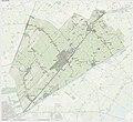 Dutch topographic map of the municipality of Ten Boer, June 2015
 -
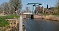 Drawing bridge near the Wolddijk-Stadsweg
 -
 Former town hall
 -
 Poorhouse


References
- ^ a b c "Kerncijfers wijken en buurten 2021". Central Bureau of Statistics. Retrieved 8 April 2022.
4 entries
- ^ "Postcodetool for 9791CT". Actueel Hoogtebestand Nederland (in Dutch). Het Waterschapshuis. Retrieved 4 February 2014.
- ^ a b c "Ten Boer". Plaatsengids (in Dutch). Retrieved 8 April 2022.
- ^ "Ten Boer - (geografische naam)". Etymologiebank (in Dutch). Retrieved 8 April 2022.
- ^ a b c d Ronald Stenvert & Redmer Alma (1998). "Ten Boer" (in Dutch). Zwolle: Waanders. ISBN 90 400 9258 3. Retrieved 7 April 2022.
- ^ "Klooster". Stichting Pelgrimeren in Groningen (in Dutch). Retrieved 8 April 2022.
External links
 Media related to Ten Boer at Wikimedia Commons
Places adjacent to Ten Boer | ||||||||||||||||
|---|---|---|---|---|---|---|---|---|---|---|---|---|---|---|---|---|
| ||||||||||||||||


- v
- t
- e
Populated places in the municipality of Groningen
- Dorkwerd
- Engelbert
- Garmerwolde
- Glimmen
- Leegkerk [nl]
- Lellens [nl]
- Meerstad
- Middelbert [nl]
- Noorddijk
- Noorderhoogebrug
- Noordlaren
- Onnen
- Paterswolde (partially)
- Sint-Annen [nl]
- Ten Boer
- Ten Post
- Thesinge
- Winneweer
- Wittewierum [nl]
- Woltersum [nl]
- Essen
- Ruischerbrug [nl]
Authority control databases | |
|---|---|
| International |
|
| National |
|


