Serra-di-Fiumorbo
You can help expand this article with text translated from the corresponding article in French. (December 2008) Click [show] for important translation instructions.
- View a machine-translated version of the French article.
- Machine translation, like DeepL or Google Translate, is a useful starting point for translations, but translators must revise errors as necessary and confirm that the translation is accurate, rather than simply copy-pasting machine-translated text into the English Wikipedia.
- Do not translate text that appears unreliable or low-quality. If possible, verify the text with references provided in the foreign-language article.
- You must provide copyright attribution in the edit summary accompanying your translation by providing an interlanguage link to the source of your translation. A model attribution edit summary is
Content in this edit is translated from the existing French Wikipedia article at [[:fr:Serra-di-Fiumorbo]]; see its history for attribution. - You may also add the template
{{Translated|fr|Serra-di-Fiumorbo}}to the talk page. - For more guidance, see Wikipedia:Translation.
Commune in Corsica, France
Serra-di-Fiumorbo | ||
|---|---|---|
Commune | ||
 The town hall in Serra-di-Fiumorbo | ||
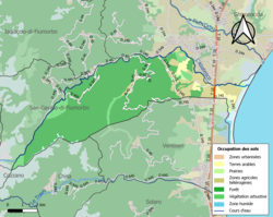 Soil types in the commune | ||
Location of Serra-di-Fiumorbo  | ||
(2020–2026) Jean-Noël Profizi[1] | | |
| Area 1 | 43.2 km2 (16.7 sq mi) | |
| Population (2021)[2] | 333 | |
| • Density | 7.7/km2 (20/sq mi) | |
| Time zone | UTC+01:00 (CET) | |
| • Summer (DST) | UTC+02:00 (CEST) | |
| INSEE/Postal code | 2B277 /20240 | |
| Elevation | 0–1,560 m (0–5,118 ft) (avg. 456 m or 1,496 ft) | |
| 1 French Land Register data, which excludes lakes, ponds, glaciers > 1 km2 (0.386 sq mi or 247 acres) and river estuaries. | ||
Serra-di-Fiumorbo is a commune in the Haute-Corse department of France on the island of Corsica.
The Aglia runs through the commune from west to east, to join the Abatesco, which defines the northern boundary of the commune.
Population
| Year | Pop. | ±% |
|---|---|---|
| 1962 | 266 | — |
| 1968 | 292 | +9.8% |
| 1975 | 214 | −26.7% |
| 1982 | 201 | −6.1% |
| 1990 | 205 | +2.0% |
| 1999 | 620 | +202.4% |
| 2008 | 304 | −51.0% |
See also
References
- ^ "Répertoire national des élus: les maires". data.gouv.fr, Plateforme ouverte des données publiques françaises (in French). 2 December 2020.
- ^ "Populations légales 2021" (in French). The National Institute of Statistics and Economic Studies. 28 December 2023.
Wikimedia Commons has media related to Serra-di-Fiumorbo.
- v
- t
- e
Communes of the Haute-Corse department 

- Aghione
- Aiti
- Alando
- Albertacce
- Aléria
- Algajola
- Altiani
- Alzi
- Ampriani
- Antisanti
- Aregno
- Asco
- Avapessa
- Barbaggio
- Barrettali
- Bastiapref
- Belgodère
- Bigorno
- Biguglia
- Bisinchi
- Borgo
- Brando
- Bustanico
- Cagnano
- Calacuccia
- Calenzana
- Calvisubpr
- Cambia
- Campana
- Campi
- Campile
- Campitello
- Canale-di-Verde
- Canari
- Canavaggia
- Carcheto-Brustico
- Carpineto
- Carticasi
- Casabianca
- Casalta
- Casamaccioli
- Casanova
- Casevecchie
- Castellare-di-Casinca
- Castellare-di-Mercurio
- Castello-di-Rostino
- Castifao
- Castiglione
- Castineta
- Castirla
- Cateri
- Centuri
- Cervione
- Chiatra
- Chisa
- Corbara
- Corscia
- Cortesubpr
- Costa
- Croce
- Crocicchia
- Erbajolo
- Érone
- Ersa
- Farinole
- Favalello
- Felce
- Feliceto
- Ficaja
- Focicchia
- Furiani
- Galéria
- Gavignano
- Ghisonaccia
- Ghisoni
- Giocatojo
- Giuncaggio
- L'Île-Rousse
- Isolaccio-di-Fiumorbo
- Lama
- Lano
- Lavatoggio
- Lento
- Linguizzetta
- Loreto-di-Casinca
- Lozzi
- Lucciana
- Lugo-di-Nazza
- Lumio
- Luri
- Manso
- Matra
- Mausoléo
- Mazzola
- Meria
- Moïta
- Moltifao
- Monacia-d'Orezza
- Moncale
- Monte
- Montegrosso
- Monticello
- Morosaglia
- Morsiglia
- Muracciole
- Murato
- Muro
- Nessa
- Nocario
- Noceta
- Nonza
- Novale
- Novella
- Occhiatana
- Ogliastro
- Olcani
- Oletta
- Olmeta-di-Capocorso
- Olmeta-di-Tuda
- Olmi-Cappella
- Olmo
- Omessa
- Ortale
- Ortiporio
- Palasca
- Pancheraccia
- Parata
- Patrimonio
- Penta-Acquatella
- Penta-di-Casinca
- Perelli
- Pero-Casevecchie
- Pianello
- Piano
- Piazzali
- Piazzole
- Piedicorte-di-Gaggio
- Piedicroce
- Piedigriggio
- Piedipartino
- Pie-d'Orezza
- Pietracorbara
- Pietra-di-Verde
- Pietralba
- Pietraserena
- Pietricaggio
- Pietroso
- Piève
- Pigna
- Pino
- Piobetta
- Pioggiola
- Poggio-di-Nazza
- Poggio-di-Venaco
- Poggio-d'Oletta
- Poggio-Marinaccio
- Poggio-Mezzana
- Polveroso
- Popolasca
- Porri
- La Porta
- Prato-di-Giovellina
- Prunelli-di-Casacconi
- Prunelli-di-Fiumorbo
- Pruno
- Quercitello
- Rapaggio
- Rapale
- Riventosa
- Rogliano
- Rospigliani
- Rusio
- Rutali
- Saint-Florent
- Saliceto
- San-Damiano
- San-Gavino-d'Ampugnani
- San-Gavino-di-Fiumorbo
- San-Gavino-di-Tenda
- San-Giovanni-di-Moriani
- San-Giuliano
- San-Lorenzo
- San-Martino-di-Lota
- San-Nicolao
- Santa-Lucia-di-Mercurio
- Santa-Lucia-di-Moriani
- Santa-Maria-di-Lota
- Santa-Maria-Poggio
- Sant'Andréa-di-Bozio
- Sant'Andréa-di-Cotone
- Sant'Antonino
- Santa-Reparata-di-Balagna
- Santa-Reparata-di-Moriani
- Santo-Pietro-di-Tenda
- Santo-Pietro-di-Venaco
- Scata
- Scolca
- Sermano
- Serra-di-Fiumorbo
- Silvareccio
- Sisco
- Solaro
- Sorbo-Ocagnano
- Sorio
- Soveria
- Speloncato
- Stazzona
- Taglio-Isolaccio
- Talasani
- Tallone
- Tarrano
- Tomino
- Tox
- Tralonca
- Urtaca
- Vallecalle
- Valle-d'Alesani
- Valle-di-Campoloro
- Valle-di-Rostino
- Valle-d'Orezza
- Vallica
- Velone-Orneto
- Venaco
- Ventiseri
- Venzolasca
- Verdèse
- Vescovato
- Vezzani
- Vignale
- Ville-di-Paraso
- Ville-di-Pietrabugno
- Vivario
- Volpajola
- Zalana
- Zilia
- Zuani
- pref: prefecture
- subpr: subprefecture
| Authority control databases: National |
|
|---|
 | This Haute-Corse geographical article is a stub. You can help Wikipedia by expanding it. |
- v
- t
- e


