Serooskerke, Walcheren
Village in Zeeland, Netherlands
Flag
Coat of arms
51°32′55″N 3°35′43″E / 51.54861°N 3.59528°E / 51.54861; 3.59528
(2021)[1]
4353[1]
Serooskerke is a village in the Dutch province of Zeeland. It is a part of the municipality of Veere, and lies about 6 km north of Middelburg.
History
The village was first mentioned before 1207 as Alerdeskirkam, and means "(private) church of Alard (person)".[3] Serooskerke is a circular church village which developed in the 12th century on a ridge. Monastery Mariëndaal was built south of the village in the 13th century. It was destroyed in 1574.[4]
The Dutch Reformed church is a single aisled church with a wide tower. The tower dates from the 15th century. The church was destroyed between 1572 and 1574 and later rebuilt.[4]
Serooskerke was home to 892 people in 1840.[5] It was a separate municipality until 1966, when it was merged with Veere.[6]
In 1966, a farm worker was digging the field near the fire station and discovered a golden coin. Almost 1,100 golden coins from the late 16th and early 17th century were discovered. The municipality was entitled to half the proceeds and built a swimming pool from the money.[5]
Gallery
-
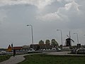 View on Serooskerke
 -
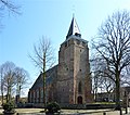 Johanneskerk


References
- ^ a b c "Kerncijfers wijken en buurten 2021". Central Bureau of Statistics. Retrieved 23 April 2022.
- ^ "Postcodetool for 4353AA". Actueel Hoogtebestand Nederland (in Dutch). Het Waterschapshuis. Retrieved 23 April 2022.
- ^ "Serooskerke - (geografische naam)". Etymologiebank (in Dutch). Retrieved 23 April 2022.
- ^ a b Piet van Cruyningen & Ronald Stenvert (2003). Serooskerke (gemeente Veere) (in Dutch). Zwolle: Waanders. ISBN 90 400 8830 6. Retrieved 23 April 2022.
- ^ a b "Serooskerke (Walcheren)". Plaatsengids (in Dutch). Retrieved 23 April 2022.
- ^ Ad van der Meer and Onno Boonstra, Repertorium van Nederlandse gemeenten, KNAW, 2011.
External links
 Media related to Serooskerke (Walcheren) at Wikimedia Commons
 | This article about a location in Zeeland is a stub. You can help Wikipedia by expanding it. |
- v
- t
- e


