Schenkendöbern
Municipality in Brandenburg, Germany
You can help expand this article with text translated from the corresponding article in German. (May 2024) Click [show] for important translation instructions.
- Machine translation, like DeepL or Google Translate, is a useful starting point for translations, but translators must revise errors as necessary and confirm that the translation is accurate, rather than simply copy-pasting machine-translated text into the English Wikipedia.
- Do not translate text that appears unreliable or low-quality. If possible, verify the text with references provided in the foreign-language article.
- You must provide copyright attribution in the edit summary accompanying your translation by providing an interlanguage link to the source of your translation. A model attribution edit summary is
Content in this edit is translated from the existing German Wikipedia article at [[:de:Schenkendöbern]]; see its history for attribution. - You may also add the template
{{Translated|de|Schenkendöbern}}to the talk page. - For more guidance, see Wikipedia:Translation.
Municipality in Brandenburg, Germany
Schenkendöbern | ||
|---|---|---|
Municipality | ||
 Church in Pinnow | ||
Location of Schenkendöbern within Spree-Neiße district 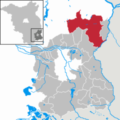 | ||
(2019–27) Ralph Homeister[1] | | |
| Area | ||
| • Total | 213.89 km2 (82.58 sq mi) | |
| Elevation | 51 m (167 ft) | |
| Population (2022-12-31)[2] | ||
| • Total | 3,495 | |
| • Density | 16/km2 (42/sq mi) | |
| Time zone | UTC+01:00 (CET) | |
| • Summer (DST) | UTC+02:00 (CEST) | |
| Postal codes | 03172 | |
| Dialling codes | 03561, 035691, 035692, 035693 | |
| Vehicle registration | SPN | |
| Website | www.schenkendoebern.de | |
Schenkendöbern (Lower Sorbian Derbno) is a municipality in the district of Spree-Neiße, in Lower Lusatia, Brandenburg, Germany.
History
From 1815 to 1947, Schenkendöbern was part of the Prussian Province of Brandenburg. From 1952 to 1990, it was part of the Bezirk Cottbus of East Germany.
Demography
-
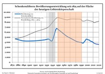 Development of population since 1875 within the current Boundaries (Blue Line: Population; Dotted Line: Comparison to Population development in Brandenburg state; Grey Background: Time of Nazi Germany; Red Background: Time of communist East Germany)
 -
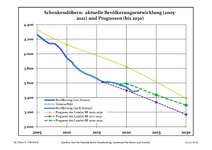 Recent Population Development and Projections (Population Development before Census 2011 (blue line); Recent Population Development according to the Census in Germany in 2011 (blue bordered line); Official projections for 2005-2030 (yellow line); for 2017-2030 (scarlet line); for 2020-2030 (green line)


|
|
|
References
- ^ Landkreis Spree-Neiße Wahl der Bürgermeisterin / des Bürgermeisters, accessed 2 July 2021.
- ^ "Bevölkerungsentwicklung und Bevölkerungsstandim Land Brandenburg Dezember 2022" (PDF). Amt für Statistik Berlin-Brandenburg (in German). June 2023.
- ^ Detailed data sources are to be found in the Wikimedia Commons.Population Projection Brandenburg at Wikimedia Commons
- v
- t
- e
Towns and municipalities in Spree-Neiße
- Briesen/Brjazyna
- Burg/Bórkowy
- Dissen-Striesow/Dešno-Strjažow
- Döbern
- Drachhausen/Hochoza
- Drebkau/Drjowk
- Drehnow/Drjenow
- Felixsee
- Forst
- Groß Schacksdorf-Simmersdorf
- Guben
- Guhrow/Góry
- Heinersbrück/Móst
- Jämlitz-Klein Düben
- Jänschwalde/Janšojce
- Kolkwitz/Gołkojce
- Neiße-Malxetal
- Neuhausen/Spree
- Peitz/Picnjo
- Schenkendöbern
- Schmogrow-Fehrow/Smogorjow-Prjawoz
- Spremberg/Grodk
- Tauer/Turjej
- Teichland/Gatojce
- Tschernitz
- Turnow-Preilack/Turnow-Pśiłuk
- Welzow/Wjelcej
- Werben/Wjerbno
- Wiesengrund/Łukojce

Authority control databases | |
|---|---|
| International |
|
| National |
|
 | This Brandenburg location article is a stub. You can help Wikipedia by expanding it. |
- v
- t
- e


