Roseires Dam
Dam in Ad Damazin, Sudan
Dam in Ad Damazin, Sudan
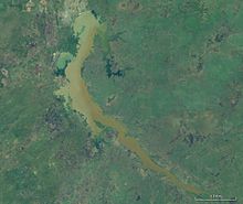
11°47′53″N 34°23′15″E / 11.79806°N 34.38750°E / 11.79806; 34.38750The Roseires Dam (Arabic: خزان الروصيرص) is a dam on the Blue Nile at Ad Damazin, just upstream of the town of Er Roseires, in Sudan. It consists of a concrete buttress dam 1 km wide with a maximum height of 68 m, and an earth dam on either side. The earth dam on the eastern bank is 4 km long, and that on the western bank is 8.5 km long. The reservoir has a surface area of about 290 km2.
The dam was completed in 1966, initially for irrigation purposes. A power generation plant, with a maximum capacity of 280 megawatts, was added in 1971.[2][3]
Extension Project
The original maximum height of the dam was 68 m, which increased to 78 m in 2013 and the dam is now 25 km long. The dam contains five 3 m x 5 m low level sluice gates designed to pass floods and sluice sediment. The dam contains a gated ogre spillway with a discharge capacity of 694 m3/s. In addition, the dam was designed with five low level outlets with a discharge capacity of 5,208 m3/s to pass floods and sluice sediment through the reservoir.[4]
References
- ^ https://web.archive.org/web/20140301022652/http://www.hydroworld.com/articles/2013/january/sudan-completes-expansion-of-1800-mw-roseiris-hydropower-project.html
- ^ "Sudan Vision Daily - Details". Archived from the original on 2013-12-24. Retrieved 2013-08-16.
- ^ "Heightening of the Roseires Dam Rehabilitation Project - OPEC Fund for International Development". opecfund.org. Retrieved 2023-03-30.
- ^ "Sudan - Roseires". www.hydropower.org. Retrieved 2023-03-30.
External links
- Sudan Government: Dams Implementation Unit Archived 2011-04-11 at the Wayback Machine
- Sudan, Electric power. Library of Congress
- Africa Dams Briefing 2010 - International Rivers p. 54
- Vintage Project Management - The tamers of rivers 1966
Authority control databases | |
|---|---|
| International |
|
| National |
|
- v
- t
- e
This article about a dam, floodgate or canal in Africa is a stub. You can help Wikipedia by expanding it. |
- v
- t
- e


