Rāpaki
Settlement in Christchurch City, New Zealand

Te Rāpaki-o-Te Rakiwhakaputa, commonly known as Rāpaki or Rapaki, is a small settlement within the Lyttelton Harbour basin.[1]
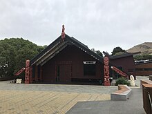
Rāpaki is one of four Banks Peninsula rūnanga (communities) based around marae (tribal meeting grounds).[2] The Rāpaki Marae, also known as Te Wheke Marae, is a meeting ground of Ngāi Tahu and its Te Hapū o Ngāti Wheke branch.[3] It includes a wharenui (meeting house), called Te Wheke opened in 2008, was carved by Riki Manuel and Fayne Robinson and the tukutuku panels were overseen by local weaver 'Aunty' Doe Parata.[4][5] The carvings of the wharenui trace the almost 400 years of continuous settlement related to the arrival of the ancestor Te Rakiwhakaputa.[5]
Rāpaki is overlooked by the peak Te Poho o Tamatea. According to one legend, the Ngāi Tahu chief Te Rakiwhakaputa named the place by laying his waist mat (rāpaki) down to claim it.[2] The full name of Rāpaki is Te Rāpaki-o-Te Rakiwhakaputa, meaning the waist mat of Te Rakiwhakaputa.[6] On 8 July 2020, the New Zealand Geographic Board assigned the full name as the official name of the locality.[7]
References
Wikimedia Commons has media related to Rapaki.
- ^ Wilson, John. "Canterbury places – Lyttelton Harbour". Te Ara: The Encyclopedia of New Zealand. Retrieved 14 July 2020.
- ^ a b "Te Hapū o Ngāti Wheke". Te Rūnanga o Ngāi Tahu. Retrieved 14 July 2020.
- ^ "Te Kāhui Māngai directory". tkm.govt.nz. Te Puni Kōkiri.
- ^ "Māori Maps". maorimaps.com. Te Potiki National Trust.
- ^ a b "Te Wheke to be reborn at Rapaki Marae". Stuff. 23 July 2009. Retrieved 17 January 2023.
- ^ Rapaki marae introduction
- ^ "Notice of the Final Determinations of the Minister for Land Information on Official Geographic Names". New Zealand Gazette. New Zealand Government. Retrieved 10 July 2020.
- v
- t
- e
Settlements of Banks Peninsula and the Port Hills, Canterbury, New Zealand
- Allandale
- Akaroa
- Ataahua
- Barrys Bay
- Birdlings Flat
- Cass Bay
- Charteris Bay
- Chorlton
- Church Bay
- Cooptown
- Corsair Bay
- Diamond Harbour
- Duvauchelle
- French Farm
- Gebbies Pass
- Gebbies Valley
- Governors Bay
- Gold Valley
- Hilltop
- Kaituna Valley
- Kukupa
- Lansdowne
- Le Bons Bay
- Little Akaloa
- Little River
- Lyttelton
- Motukarara
- McQueens Valley
- Ohinetahi
- Okains Bay
- Okuti Valley
- Onuku
- Orton Bradley Park
- Otanerito Bay
- Peraki
- Pigeon Bay
- Port Levy
- Prices Valley
- Puaha
- Purau
- Robinsons Bay
- Tai Tapu
- Takamatua
- Teddington
- Te Rāpaki-o-Te Rakiwhakaputa
- Wainui
- Ōnawe Peninsula
- Ōnuku
- Puāri
- Takapūneke
43°36′14″S 172°40′46″E / 43.6040°S 172.6795°E / -43.6040; 172.6795
 | This Canterbury Region-related geography article is a stub. You can help Wikipedia by expanding it. |
- v
- t
- e


