Puysegur Point
Puysegur Point Tawhitiwhiti-roro (Māori) | |
|---|---|
Point | |
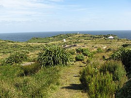 Puysegur Point Lighthouse and foundations of old lighthouse keepers buildings | |
46°09′22″S 166°36′36″E / 46.156°S 166.61°E / -46.156; 166.61 | |
| Location | Fiordland, Southland District, New Zealand |
| Offshore water bodies | Tasman Sea, Rakituma / Preservation Inlet |
| Native name | Tawhitiwhiti-roro (Māori) |
Puysegur Point is a headland located in the far southwest of the South Island of New Zealand.[1] It lies within Fiordland National Park on the southern head of Preservation Inlet and is 145 kilometres (90 mi) west-northwest of Invercargill. The name 'Puysegur' was bestowed by Lieutenant Jules Dumont d'Urville or Midshipman Jules de Blosseville during a South Pacific expedition of La Coquille; probably in honour of the French naval officer Antoine-Hyacinthe-Anne de Chastenet de Puységur (1752–1809).
Geography
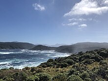
Puysegur Point has been said to be the windiest place in New Zealand, with gales recorded on an average of 48 days a year.[2] A large earthquake[3] in this region on 15 July 2009 pushed Puysegur Point closer to Australia by 30 centimetres (12 in).[4]
Biodiversity
Humpback whales pass the point during annual migrations.[5]
Lighthouse
A lighthouse on the point was first illuminated on 1 March 1879. The original wooden lighthouse was destroyed in an arson attack in 1942.[6] The lighthouse was operated by permanent lighthouse keepers from its establishment in 1879 until it was temporarily shutdown in 1980, with a further period of staffed operation from 1987 until it was fully automated and destaffed in 1989.[7]
The landing

The main access to Puysegur Point and the lighthouse is via a track from a beach landing point at Otago Retreat - a narrow waterway between the mainland and Coal Island in Preservation Inlet to the north west of the point.[8] The name Otago Retreat originates from the passage of the schooner Otago that found shelter in this narrow passage during a voyage accompanying the survey ship HMS Acheron on a survey of the South Island around 1850-51.[9][10][11] There are buildings remaining at the landing that formerly served the lighthouse. One of the buildings is a Department of Conservation shelter, known as the Landing Shed.[12]
Climate
| Climate data for Puysegur Point (1991–2020) | |||||||||||||
|---|---|---|---|---|---|---|---|---|---|---|---|---|---|
| Month | Jan | Feb | Mar | Apr | May | Jun | Jul | Aug | Sep | Oct | Nov | Dec | Year |
| Mean daily maximum °C (°F) | 16.6 (61.9) | 16.6 (61.9) | 15.7 (60.3) | 14.3 (57.7) | 12.7 (54.9) | 11.0 (51.8) | 10.7 (51.3) | 11.1 (52.0) | 12.0 (53.6) | 12.7 (54.9) | 13.7 (56.7) | 15.4 (59.7) | 13.5 (56.4) |
| Daily mean °C (°F) | 13.9 (57.0) | 14.1 (57.4) | 13.2 (55.8) | 12.0 (53.6) | 10.5 (50.9) | 8.8 (47.8) | 8.4 (47.1) | 8.7 (47.7) | 9.6 (49.3) | 10.2 (50.4) | 11.1 (52.0) | 12.8 (55.0) | 11.1 (52.0) |
| Mean daily minimum °C (°F) | 11.3 (52.3) | 11.6 (52.9) | 10.7 (51.3) | 9.6 (49.3) | 8.3 (46.9) | 6.5 (43.7) | 6.1 (43.0) | 6.3 (43.3) | 7.1 (44.8) | 7.7 (45.9) | 8.6 (47.5) | 10.2 (50.4) | 8.7 (47.6) |
| Average rainfall mm (inches) | 224.9 (8.85) | 203.0 (7.99) | 225.9 (8.89) | 207.0 (8.15) | 240.6 (9.47) | 209.5 (8.25) | 197.1 (7.76) | 211.0 (8.31) | 193.9 (7.63) | 234.8 (9.24) | 235.6 (9.28) | 195.7 (7.70) | 2,579 (101.52) |
| Source: NIWA[13] | |||||||||||||
References
- ^ "Place name detail: Puysegur Point". New Zealand Gazetteer. New Zealand Geographic Board. Retrieved 28 March 2009.
- ^ "Puysegur Point". Ashburton Guardian. 13 April 1950. Retrieved 29 January 2023 – via Papers Past.
- ^ "Magnitude 7.6 - OFF WEST COAST OF THE SOUTH ISLAND, N.Z." Archived from the original on 12 August 2009. Retrieved 31 May 2014., retrieved 24 August 2009
- ^ Ramnarayan, Abhinav (22 July 2009). "Earthquake brings New Zealand closer to Australia". The Guardian. Retrieved 4 August 2020.
- ^ Dawbin, H. W. (1995) The Migrations of Humpback Whales which Pass the New Zealand Coast. Transactions and Proceedings of the Royal Society of New Zealand. Volume 84, 1956–57. pp.147–196. Department of Zoology, Victoria University College, Wellington. National Library of New Zealand. Retrieved on 9 July 2014
- ^ "Keeper assailed - Lighthouse set on fire - Puysegur sensation". Evening Star. 10 February 1942. Retrieved 28 January 2023 – via Papers Past.
- ^ "Puysegur Point lighthouse - Maritime NZ". www.maritimenz.govt.nz. Retrieved 28 January 2023.
- ^ "Still exploring Fiordland - Part 2". Power Boat Magazine. Retrieved 2 February 2022.
- ^ "The cruise of the Luna". Wellington Independent. 13 March 1874 – via Papers Past.
- ^ "The Acheron arrives to survey New Zealand waters". nzhistory.govt.nz. Retrieved 2 February 2023.
- ^ "The Acheron's Late Surveying Cruise". New Zealander. 30 April 1851. Retrieved 2 February 2023 – via Papers Past.
- ^ "Landing Shed". Department of Conservation. Retrieved 30 January 2023.
- ^ "CliFlo – National Climate Database : Puysegur Point Aws". NIWA. Retrieved 19 May 2024.
External links
Wikimedia Commons has media related to Puysegur Point.
- Puysegur Point lighthouse at Maritime New Zealand
- Puysegur Point - Furthest Frontier II - EP7 video at Youtube
- v
- t
- e
Fiordland, New Zealand
- Big Bay
- Martins Bay
- Pearl Harbour
- Te Waewae Bay
- Anchor Island
- Arran Island
- Bauza Island
- Bay Rock
- Belle Vue Island
- Breaksea Island
- Brig Rock
- Buncrana Island
- Centre Island
- Chalky Island
- Coal Island
- Cooper Island
- Elizabeth Island
- Great Island
- Indian Island
- Long Island
- Pomona Island
- Resolution Island
- Secretary Island
- Hawea (Clio Rocks)
- Kahukura (Gold Arm)
- Kutu Parera (Gaer Arm)
- Moana Uta (Wet Jacket Arm)
- Piopiotahi (Milford Sound)
- Taipari Roa (Elizabeth Island)
- Taumoana (Five Finger Peninsula)
- Te Awaatu Channel (The Gut)
- Te Hapua (Sutherland Sound)
- Te Tapuwae o Hua (Long Sound)
- Darran Mountains
- Franklin Mountains
- Humboldt Mountains
- Hunter Mountains
- Kepler Mountains
- Murchison Mountains
- Wick Mountains
- Mitre Peak
- Mount Edgecumbe
- Mount Grono
- Mount Luxmore
- Mount Moturau
- Mount Richardson
- Mount Titiroa
- Mount Tūtoko
- Aan River
- Arthur River
- Awarua River
- Big River
- Bowen River
- Camelot River
- Carrick River
- Castle River
- Cavendish River
- Cleddau River
- Clinton River
- Coal River
- Dark River
- Donne River
- Doon River
- Dry Awarua River
- Edith River
- Eglinton River
- Electric River
- Elizabeth River
- Forgotten River
- George River
- Glaisnock River
- Gray River
- Grebe River
- Gulliver River
- Hollyford River
- Irene River
- John o'Groats River
- Juno River
- Kaipo River
- Light River
- Lyvia River
- Mike River
- Misty River
- Monowai River
- Namu River
- Newton River
- Olivine River
- Pandora River
- Pitt River
- Pyke River
- Rea River
- Red Pyke River
- Rooney River
- Seaforth River
- Shag River
- Spey River
- Stillwater River
- Talbot River
- Thurso River
- Transit River
- Tūtoko River
- Waiau River
- Waikōau River
- Wairaurāhiri River
- Waitutu River
- Walker River
- Wapiti River
- Whitewater River
- Wild Natives River
- Wilmot River
- Wilson River
- Windward River
- Wolff River
- Manapouri
- Milford Sound
- Port Craig
- Te Anau


