National Register of Historic Places listings in St. Charles County, Missouri
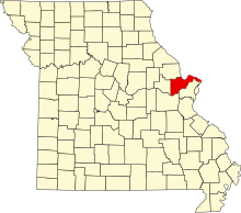
This is a list of the National Register of Historic Places listings in St. Charles County, Missouri.
This is intended to be a complete list of the properties and districts on the National Register of Historic Places in St. Charles County, Missouri, United States. Latitude and longitude coordinates are provided for many National Register properties and districts; these locations may be seen together in a map.[1]
There are 35 properties and districts listed on the National Register in the county. Another property was once listed but has been removed.
This National Park Service list is complete through NPS recent listings posted June 7, 2024.[2]
Map all coordinates using OpenStreetMap
Download coordinates as:
- KML
- GPX (all coordinates)
- GPX (primary coordinates)
- GPX (secondary coordinates)
Current listings
| [3] | Name on the Register | Image | Date listed[4] | Location | City or town | Description |
|---|---|---|---|---|---|---|
| 1 | African Church |  | November 21, 1980 (#80004366) | 554 Madison St. 38°46′57″N 90°29′17″W / 38.7825°N 90.488056°W / 38.7825; -90.488056 (African Church) | St. Charles | |
| 2 | Augusta Harmonie Verein |  | January 20, 1995 (#94001554) | Junction of Hackman and Church Rds. 38°34′32″N 90°52′44″W / 38.575556°N 90.878889°W / 38.575556; -90.878889 (Augusta Harmonie Verein) | Augusta | |
| 3 | Daniel Boone Home |  | April 11, 1973 (#73002175) | Hwy. F 38°39′06″N 90°51′14″W / 38.651667°N 90.853889°W / 38.651667; -90.853889 (Daniel Boone Home) | Defiance | |
| 4 | Commons Neighborhood Historic District | Upload image | April 10, 2017 (#100000851) | Roughly bounded by Benton Ave., Clark, 5th, Randolph, Kingshighway, 7th & 6th Sts. 38°47′23″N 90°29′06″W / 38.789840°N 90.484966°W / 38.789840; -90.484966 (Commons Neighborhood Historic District) | St. Charles | |
| 5 | Robert Ewich Farmstead |  | January 20, 1995 (#94001556) | 5336 Hackman Rd. 38°34′30″N 90°52′40″W / 38.575°N 90.877778°W / 38.575; -90.877778 (Robert Ewich Farmstead) | Augusta | |
| 6 | Charles McLee Farris House |  | January 20, 1995 (#94001559) | 5517 High St. 38°34′18″N 90°52′58″W / 38.571667°N 90.882778°W / 38.571667; -90.882778 (Charles McLee Farris House) | Augusta | |
| 7 | First Missouri State Capitol Buildings |  | April 16, 1969 (#69000313) | 208-216 S. Main St. 38°46′47″N 90°28′53″W / 38.779722°N 90.481389°W / 38.779722; -90.481389 (First Missouri State Capitol Buildings) | St. Charles | |
| 8 | Frenchtown Historic District |  | March 14, 1991 (#91000216) | Roughly bounded by N. Fifth, Clark and French Sts. and the Missouri R. 38°47′19″N 90°28′48″W / 38.788611°N 90.48°W / 38.788611; -90.48 (Frenchtown Historic District) | St. Charles | |
| 9 | Dr. C. L. Gerling House |  | January 20, 1995 (#94001558) | 245 Lower St. 38°34′22″N 90°52′56″W / 38.572778°N 90.882222°W / 38.572778; -90.882222 (Dr. C. L. Gerling House) | Augusta | |
| 10 | Harold-Knoernschild Farmstead Historic District | 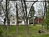 | September 29, 1994 (#94001145) | 199 Jackson St. 38°34′25″N 90°53′04″W / 38.573611°N 90.884444°W / 38.573611; -90.884444 (Harold-Knoernschild Farmstead Historic District) | Augusta | |
| 11 | Daniel Boone Hays House | Upload image | April 23, 1973 (#73002176) | SW of Defiance off Hwy. F 38°37′18″N 90°49′19″W / 38.621667°N 90.821944°W / 38.621667; -90.821944 (Daniel Boone Hays House) | Defiance | |
| 12 | Lindenwood Hall | 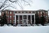 | November 29, 1978 (#78003131) | Lindenwood Colleges campus 38°47′14″N 90°29′58″W / 38.787222°N 90.499444°W / 38.787222; -90.499444 (Lindenwood Hall) | St. Charles | |
| 13 | Lindenwood Neighborhood Historic District |  | October 17, 2016 (#16000728) | Roughly bounded by Watson, Gamble, Sibley & Elm Sts. & alley between Houston & N. Kingshighway 38°47′18″N 90°29′45″W / 38.788303°N 90.495854°W / 38.788303; -90.495854 (Lindenwood Neighborhood Historic District) | St. Charles | |
| 14 | Oliver L. and Catherine Link House |  | August 6, 2013 (#13000584) | 1005 Jefferson 38°47′05″N 90°29′35″W / 38.784774°N 90.493085°W / 38.784774; -90.493085 (Oliver L. and Catherine Link House) | St. Charles | |
| 15 | Marten-Becker House |  | October 11, 1979 (#79003200) | 837 First Capitol Dr. 38°46′55″N 90°29′27″W / 38.781944°N 90.490833°W / 38.781944; -90.490833 (Marten-Becker House) | St. Charles | |
| 16 | Isaac McCormick House |  | September 10, 2004 (#04000960) | 705 MO F 38°38′28″N 90°48′18″W / 38.641111°N 90.805°W / 38.641111; -90.805 (Isaac McCormick House) | Defiance | |
| 17 | Meier General Store |  | July 12, 2002 (#02000794) | 3669 Mill St. 38°42′43″N 90°52′47″W / 38.711944°N 90.879722°W / 38.711944; -90.879722 (Meier General Store) | New Melle | |
| 18 | Mindrup House-Store |  | January 20, 1995 (#94001557) | 5543 Water St. 38°34′13″N 90°53′01″W / 38.570278°N 90.883611°W / 38.570278; -90.883611 (Mindrup House-Store) | Augusta | |
| 19 | Midtown Neighborhood Historic District |  | October 29, 2014 (#14000885) | Roughly bounded by Clark, Madison, Jefferson, Kingshighway, 2nd & 3rd Sts. 38°47′00″N 90°29′00″W / 38.7833°N 90.4833°W / 38.7833; -90.4833 (Midtown Neighborhood Historic District) | St. Charles | |
| 20 | Mt. Pleasant Winery Historic District |  | September 29, 1994 (#94001144) | 5634 High St. 38°34′13″N 90°52′30″W / 38.570278°N 90.875°W / 38.570278; -90.875 (Mt. Pleasant Winery Historic District) | Augusta | |
| 21 | Newbill-McElhiney House |  | April 11, 1972 (#72001489) | 625 S. Main St. 38°46′35″N 90°29′02″W / 38.776389°N 90.483889°W / 38.776389; -90.483889 (Newbill-McElhiney House) | St. Charles | |
| 22 | Old City Hall |  | November 14, 1980 (#80004367) | Central Ave. and Main St. 38°46′51″N 90°28′54″W / 38.780833°N 90.481667°W / 38.780833; -90.481667 (Old City Hall) | St. Charles | |
| 23 | Sage Chapel Cemetery | Upload image | November 2, 2018 (#100003087) | 8500 Veterans Memorial Pkwy. 38°48′01″N 90°41′41″W / 38.8004°N 90.6947°W / 38.8004; -90.6947 (Sage Chapel Cemetery) | O'Fallon | |
| 24 | St. Charles Historic District |  | September 22, 1970 June 4, 1987 May 1, 1991 October 10, 1996 (#70000856) 87000903 91000504 96001087 | Roughly, Main St. from Adams St. on the north to Boone's Lick Rd. on the south, east to the Missouri river, west to 2nd St. 38°46′45″N 90°28′57″W / 38.77904°N 90.48253°W / 38.77904; -90.48253 (St. Charles Historic District) | St. Charles | A historic district with over 100 contributing buildings. Originally listed on September 22, 1970 with increases on June 4, 1987, May 1, 1991 and October 10, 1996 |
| 25 | St. Charles Odd Fellows Hall |  | April 13, 1987 (#87000569) | 117 S. Main 38°46′50″N 90°28′54″W / 38.780556°N 90.481667°W / 38.780556; -90.481667 (St. Charles Odd Fellows Hall) | St. Charles | |
| 26 | St. Mary's Institute of O'Fallon |  | October 26, 2007 (#07001106) | 204 N. Main St. 38°48′49″N 90°42′07″W / 38.8134818°N 90.7020721°W / 38.8134818; -90.7020721 (St. Mary's Institute of O'Fallon) | O'Fallon | |
| 27 | St. Paul's Church |  | September 9, 1982 (#82004713) | SR D 38°42′31″N 90°52′56″W / 38.708611°N 90.882222°W / 38.708611; -90.882222 (St. Paul's Church) | New Melle | |
| 28 | J. F. Schroer House-Store |  | January 20, 1995 (#94001555) | 252 Lower St. 38°34′21″N 90°52′53″W / 38.5725°N 90.881389°W / 38.5725; -90.881389 (J. F. Schroer House-Store) | Augusta | |
| 29 | August Sehrt House |  | September 29, 1994 (#94001143) | 275 Webster St. 38°34′17″N 90°53′09″W / 38.571389°N 90.885833°W / 38.571389; -90.885833 (August Sehrt House) | Augusta | |
| 30 | Staudinger-Grumke House-Store |  | May 28, 1992 (#92000504) | 5503 Locust St. 38°34′27″N 90°52′47″W / 38.574167°N 90.879722°W / 38.574167; -90.879722 (Staudinger-Grumke House-Store) | Augusta | |
| 31 | Stone Row |  | July 29, 1969 (#69000314) | 314-330 S. Main St. 38°46′45″N 90°28′56″W / 38.779167°N 90.482222°W / 38.779167; -90.482222 (Stone Row) | St. Charles | |
| 32 | Dr. John H. Stumberg House |  | July 12, 1978 (#78003132) | 100 S. 3rd St. 38°46′53″N 90°29′00″W / 38.781389°N 90.483333°W / 38.781389; -90.483333 (Dr. John H. Stumberg House) | St. Charles | |
| 33 | Walnut Street Historic District |  | September 29, 1994 (#94001142) | Walnut and S side of Locust Sts. between Jackson and Lower Sts. 38°34′26″N 90°52′53″W / 38.573889°N 90.881389°W / 38.573889; -90.881389 (Walnut Street Historic District) | Augusta | |
| 34 | Samuel Stewart Watson House |  | September 23, 1982 (#82004714) | 205 S. Duchesne Dr. 38°47′39″N 90°30′16″W / 38.794167°N 90.504444°W / 38.794167; -90.504444 (Samuel Stewart Watson House) | St. Charles | |
| 35 | Wentzville Tobacco Company Factory |  | July 5, 1990 (#90001024) | 406 South Elm St. 38°48′37″N 90°51′05″W / 38.810278°N 90.851389°W / 38.810278; -90.851389 (Wentzville Tobacco Company Factory) | Wentzville |
Former listing
| [3] | Name on the Register | Image | Date listed | Date removed | Location | City or town | Description |
|---|---|---|---|---|---|---|---|
| 1 | Wolf-Ruebeling House | Upload image | March 29, 1983 (#83001038) | December 19, 1994 | MO 94 | Defiance | Destroyed in a 1985 fire.[5][6] |
See also
- List of National Historic Landmarks in Missouri
- National Register of Historic Places listings in Missouri
References
Wikimedia Commons has media related to National Register of Historic Places in St. Charles County, Missouri.
- ^ The latitude and longitude information provided in this table was derived originally from the National Register Information System, which has been found to be fairly accurate for about 99% of listings. Some locations in this table may have been corrected to current GPS standards.
- ^ National Park Service, United States Department of the Interior, "National Register of Historic Places: Weekly List Actions", retrieved June 7, 2024.
- ^ a b Numbers represent an alphabetical ordering by significant words. Various colorings, defined here, differentiate National Historic Landmarks and historic districts from other NRHP buildings, structures, sites or objects.
- ^ The eight-digit number below each date is the number assigned to each location in the National Register Information System database, which can be viewed by clicking the number.
- ^ "State Historic Preservation - DNR". Archived from the original on 2012-04-05. Retrieved 2011-09-05.
- ^ "Fire Destroys Pre-Civil War House". St. Louis Post-Dispatch. September 25, 1989. p. a. Retrieved August 4, 2022 – via Newspapers.com.
- v
- t
- e
- List of U.S. National Historic Landmarks by state:
- Alabama
- Alaska
- Arizona
- Arkansas
- California
- Colorado
- Connecticut
- Delaware
- Florida
- Georgia
- Hawaii
- Idaho
- Illinois
- Indiana
- Iowa
- Kansas
- Kentucky
- Louisiana
- Maine
- Maryland
- Massachusetts
- Michigan
- Minnesota
- Mississippi
- Missouri
- Montana
- Nebraska
- Nevada
- New Hampshire
- New Jersey
- New Mexico
- New York
- North Carolina
- North Dakota
- Ohio
- Oklahoma
- Oregon
- Pennsylvania
- Rhode Island
- South Carolina
- South Dakota
- Tennessee
- Texas
- Utah
- Vermont
- Virginia
- Washington
- West Virginia
- Wisconsin
- Wyoming
 National Register of Historic Places portal
 Category


Municipalities and communities of St. Charles County, Missouri, United States | ||
|---|---|---|
County seat: St. Charles | ||
| Cities |  | |
| Villages | ||
| Townships |
| |
| CDP | ||
| Other communities | ||
| Ghost towns | ||
| Footnotes | ‡This populated place also has portions in an adjacent county or counties | |
| ||


