Mrągowo County
You can help expand this article with text translated from the corresponding article in Polish. (September 2022) Click [show] for important translation instructions.
- View a machine-translated version of the Polish article.
- Machine translation, like DeepL or Google Translate, is a useful starting point for translations, but translators must revise errors as necessary and confirm that the translation is accurate, rather than simply copy-pasting machine-translated text into the English Wikipedia.
- Consider adding a topic to this template: there are already 1,471 articles in the main category, and specifying
|topic=will aid in categorization. - Do not translate text that appears unreliable or low-quality. If possible, verify the text with references provided in the foreign-language article.
- You must provide copyright attribution in the edit summary accompanying your translation by providing an interlanguage link to the source of your translation. A model attribution edit summary is
Content in this edit is translated from the existing Polish Wikipedia article at [[:pl:Powiat mrągowski]]; see its history for attribution. - You may also add the template
{{Translated|pl|Powiat mrągowski}}to the talk page. - For more guidance, see Wikipedia:Translation.
County in Warmian-Masurian Voivodeship, Poland
Mrągowo County Powiat mrągowski | |
|---|---|
County | |
 Flag  Coat of arms | |
 Location within the voivodeship | |
 Division into gminas | |
| Coordinates (Mrągowo): 53°52′N 21°18′E / 53.867°N 21.300°E / 53.867; 21.300 | |
| Country |  Poland Poland |
| Voivodeship | Warmian-Masurian |
| Seat | Mrągowo |
| Gminas | Total 5 (incl. 1 urban)
|
| Area | |
| • Total | 1,065.23 km2 (411.29 sq mi) |
| Population (2006) | |
| • Total | 50,087 |
| • Density | 47/km2 (120/sq mi) |
| • Urban | 25,620 |
| • Rural | 24,467 |
| Car plates | NMR |
| Website | http://www.powiat.mragowo.pl |
Mrągowo County (Polish: powiat mrągowski) is a unit of territorial administration and local government (powiat) in Warmian-Masurian Voivodeship, northern Poland. It came into being on January 1, 1999, as a result of the Polish local government reforms passed in 1998. Its administrative seat and largest town is Mrągowo, which lies 54 kilometres (34 mi) east of the regional capital Olsztyn. The only other town in the county is Mikołajki, lying 21 km (13 mi) east of Mrągowo.
The county covers an area of 1,065.23 square kilometres (411.3 sq mi). As of 2006 its total population is 50,087, out of which the population of Mrągowo is 21,772, that of Mikołajki is 3,848, and the rural population is 24,467.
Neighbouring counties
Mrągowo County is bordered by Kętrzyn County to the north, Giżycko County to the east, Pisz County to the south-east, Szczytno County to the south and Olsztyn County to the west.
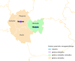
Administrative division
The county is subdivided into five gminas (one urban, one urban-rural and three rural). These are listed in the following table, in descending order of population.
| Gmina | Type | Area (km²) | Population (2006) | Seat |
| Mrągowo | urban | 14.8 | 21,772 | |
| Gmina Mikołajki | urban-rural | 256.4 | 8,435 | Mikołajki |
| Gmina Piecki | rural | 314.6 | 7,769 | Piecki |
| Gmina Mrągowo | rural | 294.9 | 7,485 | Mrągowo * |
| Gmina Sorkwity | rural | 184.6 | 4,626 | Sorkwity |
| * seat not part of the gmina | ||||
References
- Polish official population figures 2006

| ||
|---|---|---|
| City counties |  | |
| Land counties | ||
| Authority control databases |
|
|---|


