Mount Meeker
Mountain in Colorado, United States


Mount Meeker
Colorado
Allenspark, Colorado[3]
Mount Meeker is a high mountain summit of the Twin Peaks Massif in the northern Front Range of the Rocky Mountains of North America. The 13,916-foot (4,242 m) thirteener is located in the Rocky Mountain National Park Wilderness, 4.8 miles (7.7 km) west by north (bearing 285°) of the community of Allenspark in Boulder County, Colorado, United States.[1][2][3]
Mountain
Mount Meeker is the second highest summit in Rocky Mountain National Park after its neighbor Longs Peak, 0.7 miles (1.1 km) to the northwest. Due to its location southeast of Longs Peak, Mount Meeker is more visually prominent along much of the northern Front Range Urban Corridor. The peak is considered more difficult to climb, technically, than Longs Peak on certain routes.
Historical names
Neniis-otoyou’u, or nesótaieux, ("two guides") is what the Arapaho people called both Longs Peak and Mount Meeker.[4][5]
Les Deux Oreilles ("two ears") is what a couple of French trappers called Longs Peak and Mount Meeker in 1799.[6][7]
The name "Mount Meeker" was first suggested in 1873 when the Hayden Survey was performed. Present were William Byers, Anna Dickinson, and Ralph Meeker, the son of Nathan Meeker.[8] It was officially named this in 1911.[3]
Gallery
-
 Mount Meeker (left) and Longs Peak (right)
 -
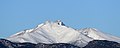 A view of the snow-covered Mount Meeker from Longmont. The rugged summit of Longs Peak is peeking out from behind.
 -
 Aerial view of Mount Meeker and Longs Peak


See also
 Geology portal
 Geography portal
 North America portal
 United States portal
 Colorado portal
 Mountains portal


- List of Colorado mountain ranges
- List of Colorado mountain summits
- List of Colorado county high points
References
- ^ a b The elevation of Mount Meeker includes an adjustment of +1.659 m (+5.44 ft) from NGVD 29 to NAVD 88.
- ^ a b c d e f "Mount Meeker, Colorado". Peakbagger.com. Retrieved November 6, 2014.
- ^ a b c d e "Mount Meeker". Geographic Names Information System. United States Geological Survey, United States Department of the Interior. Retrieved November 6, 2014.
- ^ "Center for the Study of Indigenous Languages of the West". University of Colorado Boulder. University of Colorado Boulder. Retrieved 21 October 2020.
- ^ "Longs Peak". Colorado Encyclopedia. Colorado Encyclopedia. Retrieved 21 October 2020.
For generations, Longs Peak played a part in the seasonal migrations, hunting practices, and cosmology of Ute and Arapaho Indians. The Arapaho called Longs Peak and Mount Meeker the "Two Guides," or nesótaieux, because of their physical prominence and role as landmarks for the entire region.
- ^ MacDonald, Dougald (2004). Longs Peak: The Story of Colorado's Favorite Fourteener. Big Earth Publishing. p. 40. ISBN 978-1-56579-497-9.
- ^ Evans, Joseph R. (2010). Death, Despair, and Second Chances in Rocky Mountain National Park. Johnson Books. p. 5. ISBN 978-1-55566-440-4.
- ^ Evans, Joseph R. (2010). Death, Despair, and Second Chances in Rocky Mountain National Park. Johnson Books. p. 7. ISBN 978-1-55566-440-4.
External links
Mount Meeker at Wikipedia's sister projects
 Definitions from Wiktionary
 Media from Commons
 News from Wikinews
 Quotations from Wikiquote
 Texts from Wikisource
 Textbooks from Wikibooks
 Resources from Wikiversity
- SummitPost on climbing Meeker
- v
- t
- e

- Mount Garfield
- Aspen Mountain
- Capitol Peak
- Castle Peak
- Cathedral Peak
- Chair Mountain
- Crested Butte
- Gothic Mountain
- Italian Mountain
- Maroon Bells
- Mount Emmons
- Mount Owen
- Mount Sopris
- Pyramid Peak
- Snowmass Mountain
- Snowmass Peak
- Treasure Mountain
- Black Mountain (Moffat County)
- Columbus Mountain
- Elk Mountain (Routt County)
- Hahns Peak
- Flat Top Mountain
- Sleepy Cat Peak
- Eagles Nest
- Jacque Peak
- Meridian Peak
- Mount Powell
- The Spider
- Crater Peak
- North Mamm Peak
- Clark Peak
- Arkansas Hills
- Clinton Peak
- Dyer Mountain
- Gemini Peak
- Horseshoe Mountain
- Mount Arkansas
- Mount Bross
- Mount Buckskin
- Mount Democrat
- Mount Lincoln
- Mount Sheridan
- Mount Sherman
- Pacific Peak
- West Buffalo Peak
- Elk Mountain (Grand County)
- Parkview Mountain
- Radial Mountain
- Whiteley Peak
| Sangre de Cristo Range |
|
|---|---|
| Wet Mountains |
|
| Others |
|
| Collegiate Peaks |
|
|---|---|
| Others |
|
- Crystal Peak
- Fletcher Mountain
- Peak 10
- Peak One
- Quandary Peak
- Tenmile Peak
- Bear Mountain
- Blair Mountain
- Chalk Mountains
- Cochetopa Hills
- Dawson Butte
- Diamond Peak
- Flirtation Peak
- Granite Peak
- Grand Hogback
- Grannys Nipple
- Horsefly Peak
- Lead Mountain (Grand County)
- Mount Neva
- Powell Peak
- San Luis Hills
- Storm King Mountain
- Terrible Mountain
- Two Buttes
- Ute Mountain
 | This Colorado state location article is a stub. You can help Wikipedia by expanding it. |
- v
- t
- e


