Mount Boswell
Mountain in the country of Canada


Mount Boswell
Location of Mount Boswell in Alberta
Show map of Alberta
Mount Boswell
Mount Boswell (Canada)
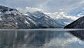
Show map of CanadaMount Boswell is a 2,454-metre (8,051-foot) summit located in Waterton Lakes National Park, in the Canadian Rockies of Alberta, Canada. It is situated along the east shore of Waterton Lake, one kilometre north of the Canada–United States border. Its nearest higher peak is Miche Wabun Peak, 5.0 km (3.1 mi) to the southeast.[1]
History
Mount Boswell was named in 1917 for Dr. W.G. Boswell, the veterinarian for the International Boundary Commission.[4][5]
The mountain's name was officially adopted in 1943 by the Geographical Names Board of Canada.[2]
Geology
Like other mountains in Waterton Lakes National Park, Mount Boswell is composed of sedimentary rock laid down during the Precambrian to Jurassic periods. Formed in shallow seas, this sedimentary rock was pushed east and over the top of younger Cretaceous period rock during the Laramide orogeny.[6]
Climate
Based on the Köppen climate classification, Mount Boswell is located in a subarctic climate with cold, snowy winters, and mild summers.[7] Temperatures can drop below −20 C with wind chill factors below −30 C. Precipitation runoff from Mount Boswell drains into Waterton Lake, thence Waterton River.
Gallery
-
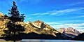
 Mount Boswell
 -
 Winter scene
 -
 Mount Boswell centered, (Mt. Cleveland to right)
 -
 circa 1919


References
- ^ a b c d "Mount Boswell". Bivouac.com. Retrieved 2019-01-14.
- ^ a b c "Mount Boswell". Geographical Names Data Base. Natural Resources Canada. Retrieved 2019-01-14.
- ^ Andrew W. Nugara, 2014, More Scrambles in the Canadian Rockies, 2nd Edition, page 80.
- ^ Place-names of Alberta. Ottawa: Geographic Board of Canada. 1928. p. 23.
- ^ "Mount Boswell". cdnrockiesdatabases.ca. Retrieved 2021-03-14.
- ^ Gadd, Ben (2008), Geology of the Rocky Mountains and Columbias
- ^ Peel, M. C.; Finlayson, B. L.; McMahon, T. A. (2007). "Updated world map of the Köppen−Geiger climate classification". Hydrol. Earth Syst. Sci. 11: 1633–1644. ISSN 1027-5606.
External links
- Parks Canada web site: Waterton Lakes National Park
- Mount Boswell weather: Mountain Forecast
- v
- t
- e
- Ball
- Bare
- Beaverfoot
- Blue
- Bow
- Crowsnest
- Elk
- Fairholme
- Fiddle
- Flathead
- Foothills
- High Rock
- Kananaskis
- Livingstone
- Lizard
- Maligne
- Massive
- Misty
- Morrissey
- Palliser
- President
- Queen Elizabeth
- Rainbow
- Ram
- Sawback
- Sentinel
- Slate
- South Jasper
- Sundance
- Terminal
- Tower of London
- Vermilion
- Victoria Cross
- Waputik
- Winston Churchill
- Continental Ranges
- Hart Ranges
- Muskwa Ranges
- Alberta
- Andromeda
- Assiniboine
- Athabasca
- Brazeau
- Bryce
- Cascade
- Castle
- Castleguard
- Clemenceau
- Columbia
- Cory
- Edith Cavell
- Forbes
- Hector
- Hosmer
- Hungabee
- Joffre
- Kitchener
- Lyell
- Heart
- Pilot
- Pyramid
- Resplendent
- Robson
- Rundle
- Sarbach
- Saskatchewan
- Smythe
- Snow Dome
- Stanley Peak
- Sulphur
- Temple
- Three Sisters
- Trinity
- Twin
- Ulysses
- Unnamed Alberta–BC mountain (formerly Mount Pétain)
- Whymper
see List of rivers of the Canadian Rockies and Category:Rivers of the Canadian Rockies
- Mountain Stoney
- Mountain Metis
| International | |
|---|---|
| National |
|
| Provincial (AB) |
|
| Provincial (BC) |
- See also
- Geography portal
- Canada portal
 | This Alberta's Rockies location article is a stub. You can help Wikipedia by expanding it. |
- v
- t
- e


