Mount Auburn Historic District
Historic district in Ohio, United States
United States historic place
Mount Auburn Historic District | |
 A map of Mount Auburn circa 1869. Visible are the house of Alphonso Taft (which is now the William Howard Taft National Historic Site), the Cincinnati Orphan Asylum and the Mount Auburn Young Ladies Institute. | |
39°7′12″N 84°30′30″W / 39.12000°N 84.50833°W / 39.12000; -84.50833 | |
| Area | 414 acres (1.68 km2), 31 buildings |
|---|---|
| Built | 1819 |
| Architectural style | Mid 19th Century Revival, Late Victorian |
| NRHP reference No. | 73001464[1] |
| Added to NRHP | March 28, 1973 |
Mount Auburn Historic District is located in the Mount Auburn neighborhood of Cincinnati, Ohio. It extends along both sides of Auburn Avenue roughly between Ringold Street and William H. Taft Road. The population of Mount Auburn was 5,094 at the 2020 census.
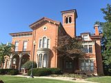
The District was placed on the National Register of Historic Places on March 28, 1973 (No. 73001464). Mount Auburn was founded as a hilltop retreat for Cincinnati's social elite where wealthier people could escape the dirt, heat, smoke and crowded conditions of the lower city. Ornate historic mansions with incredible panoramic views still reflect this heritage.
The district contains notable houses of Federal, Greek Revival, Italian Villa, Romanesque Revival, and Georgian Revival styles. The houses date from 1819 to the turn of the century and are associated with the prominent Cincinnatians. Noted residents include President William Howard Taft.
Demographics
| Year | Pop. | ±% | |
|---|---|---|---|
| 1900 | 11,625 | — | |
| 1910 | 13,168 | +13.3% | |
| 1920 | 15,100 | +14.7% | |
| 1930 | 15,512 | +2.7% | |
| 1940 | 14,264 | −8.0% | |
| 1950 | 16,769 | +17.6% | |
| 1960 | 16,821 | +0.3% | |
| 1970 | 12,549 | −25.4% | |
| 1980 | 8,889 | −29.2% | |
| 1990 | 7,452 | −16.2% | |
| 2000 | 6,516 | −12.6% | |
| 2010 | 4,904 | −24.7% | |
| 2020 | 5,070 | +3.4% | |
| |||
Source - City of Cincinnati Statistical Database
History
Mt. Auburn was for a long time almost the only suburb of the city. It was at first called Keys' Hill,[2] after an old settler, and this name was used until 1837. By 1826 a number of prominent citizens had taken up residence there.[3]
Mount Auburn was platted as a town in 1837. It owes its name to the then newly established Mount Auburn Cemetery of Boston.[4] By 1842, it extended from Liberty Street (Liberty Street got its name because the city laws were not enforced north of it and it was the location of the "northern liberties" – gambling, drinking and carousing) to McMillan Street (note that the historic district only goes as far south as Ringold Street, the rest of the Mount Auburn neighborhood to the south is the Prospect Hill Historic District).[2] Mount Auburn was annexed to the City of Cincinnati in 1849.[5]
Buildings and sites
- William Howard Taft National Historic Site
- The Mount Auburn Young Ladies Institute was established in 1856 to provide higher education to females. It was known for a strenuous curriculum, particularly in science and mathematics. The Institute was located on twenty-three acres of land that was landscaped by a gardener. Only four acres were cultivated for vegetable and flower gardens and a fruit orchard. The remainder was part of the landscaped area.
- Cincinnati Orphan Asylum
- Hopkins Park is a small hillside park in Mt. Auburn
- Inwood Park was created in 1904 after the purchase of a stone quarry. Its pavilion, built in 1910 in Mission style, is one of the earliest buildings extant in Cincinnati's parks.
- Jackson Hill Park
- Glencoe-Auburn Hotel and Glencoe-Auburn Place Row Houses
- Prospect Hill
Other notable architecture
- Mount Auburn Presbyterian Church, 103 William Howard Taft Road
- Former First District School, 412 Liberty Hill
- Mt. Auburn Cable Railway Building, Corner of Highland and Dorchester
- The William Howard Doane House (Sunny Side), 2223 Auburn Avenue
- Mt. Auburn Baptist Church, 2147 Auburn Avenue
- Adam Riddle House, 2021 Auburn Avenue
- The Henry Powell House, 2209 Auburn Avenue
Schools
- God's Bible School and College
- Mount Auburn Preparatory Academy
- William Howard Taft Elementary
- Christ College of Nursing
Medical institutions
- The Christ Hospital
- Planned Parenthood Elizabeth Campbell Surgical Center
Gallery
-
 The cover of a catalog for the Mount Auburn Young Ladies Institute. The landscape of historic Mount Auburn is visible.
 -
 Mount Auburn is seen here as e in this drawing from circa 1861.
 -
 Sunny Side (1850), residence of William Howard Doane


References
- ^ "National Register Information System". National Register of Historic Places. National Park Service. January 23, 2007.
- ^ a b Rider, Peg (May 21, 1989). "Mt. Auburn". Prospect Hill, A Neighborhood Reborn (1807–present). Archived from the original on September 30, 2007. Retrieved June 24, 2007.
- ^ Clarke, S. J. (1912). Cincinnati, the Queen City, 1788-1912, Volume 2. The S. J. Clarke Publishing Company. p. 531. Retrieved May 20, 2013.
- ^ Stradling, David (October 1, 2003). Cincinnati: From River City to Highway Metropolis. Arcadia Publishing. p. 37. ISBN 9780738524405. Retrieved May 25, 2013.
- ^ Federal Writers' Project (1943). Cincinnati, a Guide to the Queen City and Its Neighbors. p. 357. ISBN 9781623760519. Retrieved May 4, 2013.
External links
Wikimedia Commons has media related to Mount Auburn, Cincinnati.
- Mt. Auburn Community Website
- William Howard Taft National Historic Site (National Park Service)
- Mount Auburn Historic District
- Map Mount Auburn Historic District
- v
- t
- e
 City of Cincinnati
- Avondale
- The Banks
- Bond Hill
- California
- Camp Washington
- Carthage
- Clifton
- College Hill
- Columbia-Tusculum
- Corryville
- CUF
- Downtown
- East End
- East Price Hill
- East Walnut Hills
- East Westwood
- English Woods
- Evanston
- Hartwell
- The Heights
- Hyde Park
- Kennedy Heights
- Linwood
- Lower Price Hill
- Madisonville
- Millvale
- Mount Adams
- Mount Airy
- Mount Auburn
- Mount Lookout
- Mount Washington
- North Avondale
- North Fairmount
- Northside
- Oakley
- Over-the-Rhine
- Paddock Hills
- Pendleton
- Pleasant Ridge
- Queensgate
- Riverside
- Roselawn
- Sayler Park
- Sedamsville
- South Cumminsville
- South Fairmount
- Spring Grove Village
- The Villages of Roll Hill
- Walnut Hills
- West End
- West Price Hill
- Westwood
- Winton Hills

| Historic places | |||||||
|---|---|---|---|---|---|---|---|
| Riots | |||||||
| American Civil War |
|
| Museums |
|
|---|---|
| Performing arts | |
| Traditions |
| Professional | |
|---|---|
| Golf Tournaments | |
| College | |
| High school | |
| Tournaments | |
| Venues |
| Public school districts |
|
|---|---|
| Universities and colleges | |
| Education centers | |
| Other |
| Historical services |
|---|


