Mistaya Mountain
Mountain in the country of Canada


Mistaya Mountain
Location in Alberta and British Columbia
Show map of Alberta
Mistaya Mountain
Mistaya Mountain (British Columbia)
Show map of British ColumbiaMistaya Mountain is located on the border of Alberta and British Columbia, on the Continental Divide. It was named in 1918.[1][3] Mistaya is either the Cree name for "grizzly bear"[6] or is the Stoney word for "much wind".[7]
Mistaya is an easyish, non-technical mountain with good views, especially to the north, north-west and south.
Geology
Mistaya Mountain is composed of sedimentary rock laid down during the Precambrian to Jurassic periods. Formed in shallow seas, this sedimentary rock was pushed east and over the top of younger rock during the Laramide orogeny.[8]
Climate
Based on the Köppen climate classification, Mistaya Mountain is located in a subarctic climate zone with cold, snowy winters, and mild summers.[9] Temperatures can drop below −20 °C (−4 °F) with wind chill factors below −30 °C (−22 °F).
Gallery
-
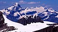 View from Mistaya: Mts. Forbes, Lyell & Columbia
 -
 View from Mistaya: the Wapta Icefield


See also
 Mountains portal
- List of peaks on the British Columbia–Alberta border
- List of mountains in the Canadian Rockies

References
- ^ a b c "Mistaya Mountain". cdnrockiesdatabases.ca. Retrieved 2019-08-25.
- ^ "Topographic map of Mistaya Mountain". opentopomap.org. Retrieved 2021-10-11.
- ^ a b c d e "Mistaya Mountain". Bivouac.com. Retrieved 2019-08-26.
- ^ a b "Mistaya Mountain (AB)". Geographical Names Data Base. Natural Resources Canada. Retrieved 2019-08-26.
- ^ Thorington, J. Monroe (1966) [1921]. "Kicking Horse Pass to Howse Pass". A Climber's Guide to the Rocky Mountains of Canada. With the collaboration of Putnam, William Lowell (6th ed.). American Alpine Club. p. 146. ISBN 978-1376169003.
- ^ Fromhold, Joachim (2012). 2001 INDIAN PLACE NAMES OF THE WEST, Part 2: Listings by Nation. ISBN 9781300389118. Retrieved 2019-08-26.
- ^ Boles, Glen W.; Laurilla, Roger W.; Putnam, William L. (1990). Place Names of the Canadian Alps. Revelstoke, B.C.: Footprint Publishing. p. 200. ISBN 0-9691621-4-6.
- ^ Gadd, Ben (2008). Geology of the Rocky Mountains and Columbias.
- ^ Peel, M. C.; Finlayson, B. L.; McMahon, T. A. (2007). "Updated world map of the Köppen−Geiger climate classification". Hydrol. Earth Syst. Sci. 11: 1633–1644. ISSN 1027-5606.
External links
- "Mistaya Mountain". BC Geographical Names.
- v
- t
- e
- Ball
- Bare
- Beaverfoot
- Blue
- Bow
- Crowsnest
- Elk
- Fairholme
- Fiddle
- Flathead
- Foothills
- High Rock
- Kananaskis
- Livingstone
- Lizard
- Maligne
- Massive
- Misty
- Morrissey
- Palliser
- President
- Queen Elizabeth
- Rainbow
- Ram
- Sawback
- Sentinel
- Slate
- South Jasper
- Sundance
- Terminal
- Tower of London
- Vermilion
- Victoria Cross
- Waputik
- Winston Churchill
- Continental Ranges
- Hart Ranges
- Muskwa Ranges
- Alberta
- Andromeda
- Assiniboine
- Athabasca
- Brazeau
- Bryce
- Cascade
- Castle
- Castleguard
- Clemenceau
- Columbia
- Cory
- Edith Cavell
- Forbes
- Hector
- Hosmer
- Hungabee
- Joffre
- Kitchener
- Lyell
- Heart
- Pilot
- Pyramid
- Resplendent
- Robson
- Rundle
- Sarbach
- Saskatchewan
- Smythe
- Snow Dome
- Stanley Peak
- Sulphur
- Temple
- Three Sisters
- Trinity
- Twin
- Ulysses
- Unnamed Alberta–BC mountain (formerly Mount Pétain)
- Whymper
see List of rivers of the Canadian Rockies and Category:Rivers of the Canadian Rockies
- Mountain Stoney
- Mountain Metis
| International | |
|---|---|
| National |
|
| Provincial (AB) |
|
| Provincial (BC) |
- See also
- Geography portal
- Canada portal
 | This Alberta's Rockies location article is a stub. You can help Wikipedia by expanding it. |
- v
- t
- e
 | This article about a location in the Columbia-Shuswap Regional District, Canada is a stub. You can help Wikipedia by expanding it. |
- v
- t
- e


