Malguénac
Commune in Brittany, France
Commune in Brittany, France
Malguénac Malgeneg | ||
|---|---|---|
Commune | ||
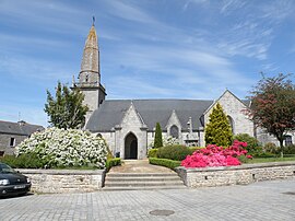 The parish church in Malguénac | ||
Location of Malguénac  | ||
(2020–2026) Dominique Guegan[1] | | |
| Area 1 | 38.45 km2 (14.85 sq mi) | |
| Population (2021)[2] | 1,841 | |
| • Density | 48/km2 (120/sq mi) | |
| Time zone | UTC+01:00 (CET) | |
| • Summer (DST) | UTC+02:00 (CEST) | |
| INSEE/Postal code | 56125 /56300 | |
| Elevation | 73–222 m (240–728 ft) | |
| 1 French Land Register data, which excludes lakes, ponds, glaciers > 1 km2 (0.386 sq mi or 247 acres) and river estuaries. | ||
Malguénac (French pronunciation: [malɡenak]; Breton: Malgeneg) is a commune in the Morbihan department of Brittany in north-western France.[3]
Geography
The village centre is located 6 km (3.7 mi) west of Pontivy, 44 km (27 mi) northeast of Lorient and 52 km (32 mi) northwest of Vannes. Malguénac is border by Cléguérec to the north, by Séglien to the west, by Guern to the south and by Pontivy and Le Sourn to the east. Apart from the village centre, there are many hamlets in the commune. Historically, Malguénac belongs to Vannetais.
Demographics
Inhabitants of Malguénac are called in French Malguénacois. After having declined for a long time, the population of the municipality has been increasing steadily since 1975.
|
| ||||||||||||||||||||||||||||||||||||||||||||||||||||||||||||||||||||||||||||||||||||||||||||||||||||||||||||||||||
| |||||||||||||||||||||||||||||||||||||||||||||||||||||||||||||||||||||||||||||||||||||||||||||||||||||||||||||||||||
| Source: EHESS[4] and INSEE (1968-2020)[5] | |||||||||||||||||||||||||||||||||||||||||||||||||||||||||||||||||||||||||||||||||||||||||||||||||||||||||||||||||||
Map

History
An epidemic of plague occasioned several deaths between March and October 1598 in the parish.
See also
References
- ^ "Maires du Morbihan" (PDF). Préfecture du Morbihan. 7 July 2020.
- ^ "Populations légales 2021". The National Institute of Statistics and Economic Studies. 28 December 2023.
- ^ INSEE commune file
- ^ Des villages de Cassini aux communes d'aujourd'hui: Commune data sheet Malguénac, EHESS (in French).
- ^ Population en historique depuis 1968, INSEE
External links
Wikimedia Commons has media related to Malguénac.
- Base Mérimée: Search for heritage in the commune, Ministère français de la Culture. (in French)
- Mayors of Morbihan Association (in French)
- v
- t
- e

- Allaire
- Ambon
- Arradon
- Arzal
- Arzon
- Augan
- Auray
- Baden
- Bangor
- Baud
- Béganne
- Beignon
- Belz
- Berné
- Berric
- Bignan
- Billiers
- Billio
- Bohal
- Le Bono
- Brandérion
- Brandivy
- Brech
- Bréhan
- Brignac
- Bubry
- Buléon
- Caden
- Calan
- Camoël
- Camors
- Campénéac
- Carentoir
- Carnac
- Caro
- Caudan
- La Chapelle-Neuve
- Cléguer
- Cléguérec
- Colpo
- Concoret
- Cournon
- Le Cours
- Crac'h
- Crédin
- Le Croisty
- La Croix-Helléan
- Cruguel
- Damgan
- Elven
- Erdeven
- Étel
- Évellys
- Évriguet
- Le Faouët
- Férel
- Forges de Lanouée
- Les Fougerêts
- La Gacilly
- Gâvres
- Gestel
- Gourhel
- Gourin
- Grand-Champ
- La Grée-Saint-Laurent
- Groix
- Guégon
- Guéhenno
- Gueltas
- Guémené-sur-Scorff
- Guénin
- Guer
- Guern
- Le Guerno
- Guidel
- Guillac
- Guilliers
- Guiscriff
- Helléan
- Hennebont
- Le Hézo
- Hœdic
- Houat
- Île-aux-Moines
- Île-d'Arz
- Inguiniel
- Inzinzac-Lochrist
- Josselin
- Kerfourn
- Kergrist
- Kernascléden
- Kervignac
- Landaul
- Landévant
- Lanester
- Langoëlan
- Langonnet
- Languidic
- Lantillac
- Lanvaudan
- Lanvénégen
- Larmor-Baden
- Larmor-Plage
- Larré
- Lauzach
- Lignol
- Limerzel
- Lizio
- Locmalo
- Locmaria
- Locmaria-Grand-Champ
- Locmariaquer
- Locminé
- Locmiquélic
- Locoal-Mendon
- Locqueltas
- Lorientsubpr
- Loyat
- Malansac
- Malestroit
- Malguénac
- Marzan
- Mauron
- Melrand
- Ménéac
- Merlevenez
- Meslan
- Meucon
- Missiriac
- Mohon
- Molac
- Monteneuf
- Monterblanc
- Montertelot
- Moréac
- Moustoir-Ac
- Muzillac
- Néant-sur-Yvel
- Neulliac
- Nivillac
- Nostang
- Noyal-Muzillac
- Noyal-Pontivy
- Le Palais
- Péaule
- Peillac
- Pénestin
- Persquen
- Plaudren
- Plescop
- Pleucadeuc
- Pleugriffet
- Ploemel
- Ploemeur
- Ploërdut
- Ploeren
- Ploërmel
- Plouay
- Plougoumelen
- Plouharnel
- Plouhinec
- Plouray
- Pluherlin
- Plumelec
- Pluméliau-Bieuzy
- Plumelin
- Plumergat
- Pluneret
- Pluvigner
- Pontivysubpr
- Pont-Scorff
- Porcaro
- Port-Louis
- Priziac
- Questembert
- Quéven
- Quiberon
- Quistinic
- Radenac
- Réguiny
- Réminiac
- Riantec
- Rieux
- La Roche-Bernard
- Rochefort-en-Terre
- Rohan
- Roudouallec
- Ruffiac
- Le Saint
- Saint-Abraham
- Saint-Aignan
- Saint-Allouestre
- Saint-Armel
- Saint-Avé
- Saint-Barthélemy
- Saint-Brieuc-de-Mauron
- Saint-Caradec-Trégomel
- Saint-Congard
- Saint-Dolay
- Sainte-Anne-d'Auray
- Sainte-Brigitte
- Sainte-Hélène
- Saint-Gérand-Croixanvec
- Saint-Gildas-de-Rhuys
- Saint-Gonnery
- Saint-Gorgon
- Saint-Gravé
- Saint-Guyomard
- Saint-Jacut-les-Pins
- Saint-Jean-Brévelay
- Saint-Jean-la-Poterie
- Saint-Laurent-sur-Oust
- Saint-Léry
- Saint-Malo-de-Beignon
- Saint-Malo-des-Trois-Fontaines
- Saint-Marcel
- Saint-Martin-sur-Oust
- Saint-Nicolas-du-Tertre
- Saint-Nolff
- Saint-Perreux
- Saint-Philibert
- Saint-Pierre-Quiberon
- Saint-Servant
- Saint-Thuriau
- Saint-Tugdual
- Saint-Vincent-sur-Oust
- Sarzeau
- Sauzon
- Séglien
- Séné
- Sérent
- Silfiac
- Le Sourn
- Sulniac
- Surzur
- Taupont
- Théhillac
- Theix-Noyalo
- Le Tour-du-Parc
- Tréal
- Trédion
- Treffléan
- Tréhorenteuc
- La Trinité-Porhoët
- La Trinité-sur-Mer
- La Trinité-Surzur
- Val d'Oust
- Vannespref
- La Vraie-Croix
- pref: prefecture
- subpr: subprefecture
| Authority control databases: National |
|
|---|
 | This Morbihan geographical article is a stub. You can help Wikipedia by expanding it. |
- v
- t
- e


