Madrid Río
Urban park in Madrid, Spain
You can help expand this article with text translated from the corresponding article in Spanish. (June 2021) Click [show] for important translation instructions.
- Machine translation, like DeepL or Google Translate, is a useful starting point for translations, but translators must revise errors as necessary and confirm that the translation is accurate, rather than simply copy-pasting machine-translated text into the English Wikipedia.
- Consider adding a topic to this template: there are already 1,030 articles in the main category, and specifying
|topic=will aid in categorization. - Do not translate text that appears unreliable or low-quality. If possible, verify the text with references provided in the foreign-language article.
- You must provide copyright attribution in the edit summary accompanying your translation by providing an interlanguage link to the source of your translation. A model attribution edit summary is
Content in this edit is translated from the existing Spanish Wikipedia article at [[:es:Madrid Río]]; see its history for attribution. - You may also add the template
{{Translated|es|Madrid Río}}to the talk page. - For more guidance, see Wikipedia:Translation.
| Madrid Río Park | |
|---|---|
 | |
 | |
| Location | Madrid, Spain |
| Operated by | Ayuntamiento de Madrid |
| Status | Public park |
Madrid Río is an urban park in the Spanish capital Madrid, built along an urban stretch of the Manzanares River following the burial of the M-30 bypass road in this area. It is the result of a project led by the architect Ginés Garrido, who won the international ideas competition organised by the Madrid City Council in 2005 to redevelop the area.[1]
The project started with the idea of recovering the banks of the Manzanares River for the use and enjoyment of the citizens. The section of the river that is now known as Madrid Río is the section that was boxed in by the M-30 bypass road, a road that isolated the river between the two directions of the highway as well as creating a barrier and fracture between the two sides of the city, the district of Arganzuela on the left bank, and the districts of Latina, Carabanchel and Usera on the right bank. The connection of the M-30 with the A-5 motorway, the road to Extremadura, separated the city in an impassable way from Casa de Campo, Madrid's largest park. The project involved the undergrounding of the M-30 in this area as well as that section of the A-5 running parallel to Casa de Campo.
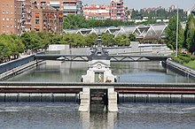

There are seven dams that regulate the river as it passes through the city. They receive the waters of the Manzanares River after passing through the Santillana reservoir, in Manzanares el Real, and the El Pardo reservoir, in the municipality of Madrid, which is why they are numbered from 3 to 9. Their mechanisms and locks have been repaired and the dams have been used for the new system of crossings. Initially, the project for the renaturation of the Manzanares River as it passes through Madrid Río contemplated the opening of all the dams, except the last one, to create the conditions that would make it possible for the Madrid Río rowing school to train, but finally, contrary to what was first agreed and due to pressure from the local residents, it was also decided to also open the last one so that the river could flow freely.
The water level has been dropped as the natural flow of the river has been restored. Accessible wooden boards and fish ladders have been added to encourage the continuity of the underwater fauna along the river. There has been a noticeable improvement in avian biodiversity along the river with herons and kingfishers being regular visitors.[2]
Notes
External links
Wikimedia Commons has media related to Madrid Río.
40°23′55″N 3°42′42″W / 40.3985°N 3.7117°W / 40.3985; -3.7117


