Lys-lez-Lannoy
Commune in Hauts-de-France, France

Coat of arms
Location of Lys-lez-Lannoy

(2020–2026) Noar Hannache[1]
1
(2021)[2]
59367 /59390
(avg. 33 m or 108 ft)
Lys-lez-Lannoy (French pronunciation: [lis le lanwa], literally Lys near Lannoy; West Flemish: Lis by Lannoy) is a commune in the Nord department in northern France. It is part of the Métropole Européenne de Lille.[3]
Population
Graphs are unavailable due to technical issues. There is more info on Phabricator and on MediaWiki.org. |
| Year | Pop. | ±% p.a. |
|---|---|---|
| 1968 | 10,403 | — |
| 1975 | 10,984 | +0.78% |
| 1982 | 11,077 | +0.12% |
| 1990 | 12,300 | +1.32% |
| 1999 | 13,018 | +0.63% |
| 2007 | 12,783 | −0.23% |
| 2012 | 13,317 | +0.82% |
| 2017 | 13,422 | +0.16% |
| Source: INSEE[4] | ||
Heraldry
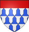 | The arms of Lys-lez-Lannoy are blazoned : Vair, a chief gules.
|
See also
References
- ^ "Répertoire national des élus: les maires" (in French). data.gouv.fr, Plateforme ouverte des données publiques françaises. 13 September 2022.
- ^ "Populations légales 2021". The National Institute of Statistics and Economic Studies. 28 December 2023.
- ^ INSEE commune file
- ^ Population en historique depuis 1968, INSEE
Wikimedia Commons has media related to Lys-lez-Lannoy.
- v
- t
- e
Communes of the Métropole Européenne de Lille 

- Allennes-les-Marais
- Annœullin
- Anstaing
- Armentières
- Aubers
- Baisieux
- La Bassée
- Bauvin
- Beaucamps-Ligny
- Bois-Grenier
- Bondues
- Bousbecque
- Bouvines
- Capinghem
- Carnin
- La Chapelle-d'Armentières
- Chéreng
- Comines
- Croix
- Deûlémont
- Don
- Emmerin
- Englos
- Ennetières-en-Weppes
- Erquinghem-le-Sec
- Erquinghem-Lys
- Escobecques
- Faches-Thumesnil
- Forest-sur-Marque
- Fournes-en-Weppes
- Frelinghien
- Fretin
- Fromelles
- Gruson
- Hallennes-lez-Haubourdin
- Halluin
- Hantay
- Haubourdin
- Hem
- Herlies
- Houplin-Ancoisne
- Houplines
- Illies
- Lambersart
- Lannoy
- Le Maisnil
- Leers
- Lesquin
- Lezennes
- Lille (includes the associate-communes of Hellemmes and Lomme)
- Linselles
- Lompret
- Loos
- Lys-lez-Lannoy
- La Madeleine
- Marcq-en-Barœul
- Marquette-lez-Lille
- Marquillies
- Mons-en-Barœul
- Mouvaux
- Neuville-en-Ferrain
- Noyelles-lès-Seclin
- Pérenchies
- Péronne-en-Mélantois
- Prémesques
- Provin
- Quesnoy-sur-Deûle
- Radinghem-en-Weppes
- Ronchin
- Roncq
- Roubaix
- Sailly-lez-Lannoy
- Sainghin-en-Mélantois
- Sainghin-en-Weppes
- Saint-André-lez-Lille
- Salomé
- Santes
- Seclin
- Sequedin
- Templemars
- Toufflers
- Tourcoing
- Tressin
- Vendeville
- Verlinghem
- Villeneuve-d'Ascq
- Wambrechies
- Warneton
- Wasquehal
- Wattignies
- Wattrelos
- Wavrin
- Wervicq-Sud
- Wicres
- Willems
Authority control databases | |
|---|---|
| International |
|
| National |
|
| Geographic |
|
| Other |
|
 | This Nord geographical article is a stub. You can help Wikipedia by expanding it. |
- v
- t
- e


