List of places in the Northern Territory by population
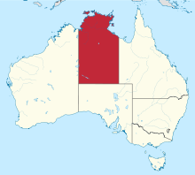
The Northern Territory is a self governing territory of Australia. It has a population of 232,605 as of the 2021 Australian census[1] and occupies an area of 1,334,404 square kilometres (515,216 sq mi).[2] Official population statistics are published by the Australian Bureau of Statistics, which conducts a census every five years. The most recent census for which data has been released is the 2021 census.[3]
Urban centres and localities by population
SA1's are areas that subdivide all of Australia, and have a population between 200 and 800 people and an average population size of 400.[4] Urban centres and localities are defined by the Australian Bureau of Statistics to be clusters of urban SA1's. Clusters with a population higher than 1,000 are considered urban centres and clusters with a population between 200 and 999 are considered localities.[5]
| Rank | Urban centre | Population | |||||
|---|---|---|---|---|---|---|---|
| 2011 census | Ref. | 2016 census | Ref. | 2021 census | Ref. | ||
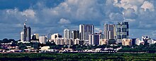
| 1 | Darwin | 103,016 | [1] | 118,456 | [2] | 122,207 | [3] |
| 2 | Alice Springs | 24,208 | [4] | 23,726 | [5] | 24,855 | [6] |
| 3 | Katherine | 6,094 | [7] | 6,303 | [8] | 5,980 | [9] |
| 4 | Nhulunbuy | 3,933 | [10] | 3,088 | [11] | 3,267 | [12] |
| 5 | Tennant Creek | 3,062 | [13] | 2,991 | [14] | 2,949 | [15] |
| 6 | Galiwinku | 2,124 | [16] | 2,088 | [17] | 2,199 | [18] |
| 7 | Wadeye | 2,112 | [19] | 2,280 | [20] | 1,924 | [21] |
| 8 | Wurrumiyanga (Nguiu) | 1,527 | [22] | 1,563 | [23] | 1,421 | [24] |
| 9 | Gunbalanya (Oenpelli) | 1,171 | [25] | 1,117 | [26] | 1,153 | [27] |
| 10 | Milingimbi | 1,081 | [28] | 1,225 | [29] | 1,097 | [30] |
| 11 | Ngukurr | 1,056 | [31] | 1,149 | [32] | 1,088 | [33] |
| 12 | Angurugu | 835 | [34] | 855 | [35] | 883 | [36] |
| 13 | Yulara | 888 | [37] | 759 | [38] | 853 | [39] |
| 14 | Ramingining | 833 | [40] | 872 | [41] | 814 | [42] |
| 15 | Jabiru | 1,129 | [43] | 1,081 | [44] | 755 | [45] |
| 16 | Borroloola | 926 | [46] | 871 | [47] | 755 | [48] |
| 17 | Alyangula | 986 | [49] | 873 | [50] | 751 | [51] |
| 18 | Yuendumu | 687 | [52] | 759 | [53] | 740 | [54] |
| 19 | Gapuwiyak | 874 | [55] | 923 | [56] | 705 | [57] |
| 20 | Humpty Doo | 569 | [58] | 678 | [59] | 660 | [60] |
| 21 | Yirrkala | 843 | [61] | 809 | [62] | 657 | [63] |
| 22 | Lajamanu | 656 | [64] | 598 | [65] | 653 | [66] |
| 23 | Minyerri | — | 618 | [67] | 650 | [68] | |
| 24 | Santa Teresa (Ltyentye Purte) | 555 | [69] | 580 | [70] | 603 | [71] |
| 25 | Daguragu – Kalkarindji | 542 | [72] | 575 | [73] | 575 | [74] |
| 26 | Howard Springs | 612 | [75] | 595 | [76] | 569 | [77] |
| 27 | Hermannsburg | 625 | [78] | 605 | [79] | 551 | [80] |
| 28 | Wugular (Beswick) | 511 | [81] | 531 | [82] | 542 | [83] |
| 29 | Ampilatwatja | 365 | [84] | 418 | [85] | 439 | [86] |
| 30 | Papunya | 418 | [87] | 404 | [88] | 438 | [89] |
| 31 | Warruwi | 423 | [90] | 389 | [91] | 432 | [92] |
| 32 | Ilparpa | 433 | [93] | 360 | [94] | 424 | [95] |
| 33 | Wagait Beach – Mandorah | 368 | [96] | 461 | [97] | 422 | [98] |
| 34 | Walungurru (Kintore) | 454 | [99] | 410 | [100] | 420 | [101] |
| 35 | Umbakumba | 441 | [102] | 503 | [103] | 419 | [104] |
| 36 | Milikapiti | 447 | [105] | 401 | [106] | 414 | [107] |
| 37 | Ali Curung | 535 | [108] | 494 | [109] | 394 | [110] |
| 38 | Kaltukatjara (Docker River) | 295 | [111] | 394 | [112] | 394 | [113] |
| 39 | Batchelor | 336 | [114] | 466 | [115] | 371 | [116] |
| 40 | Nganmarriyanga (Palumpa) | 377 | [117] | 390 | [118] | 364 | [119] |
| 41 | Alpurrurulam | 441 | [120] | 420 | [121] | 350 | [122] |
| 42 | Nauiyu Nambiyu (Daly River) | 454 | [123] | 378 | [124] | 350 | [125] |
| 43 | Barunga | 313 | [126] | 363 | [127] | 337 | [128] |
| 44 | Mataranka | 244 | [129] | 310 | [130] | 327 | [131] |
| 45 | Pine Creek | 380 | [132] | 328 | [133] | 318 | [134] |
| 46 | Pirlangimpi | 371 | [135] | 371 | [136] | 317 | [137] |
| 47 | Mutitjulu | 210 | [138] | 323 | [139] | 296 | [140] |
| 48 | Elliot | 348 | [141] | 339 | [142] | 287 | [143] |
| 49 | Yarralin | 266 | [144] | 293 | [145] | 283 | [146] |
| 50 | Timber Creek | — | 249 | [147] | 278 | [148] | |
| 51 | Minjilang | 309 | [149] | 247 | [150] | 265 | [151] |
| 52 | Jilkminggan | 280 | [152] | 301 | [153] | 263 | [154] |
| 53 | Bulman – Weemol | 291 | [155] | 280 | [156] | 263 | [157] |
| 54 | Nyirripi | 210 | [158] | 236 | [159] | 251 | [160] |
| 55 | Adelaide River | 237 | [161] | 265 | [162] | 243 | [163] |
| 56 | Gunyangara | — | 240 | [164] | 241 | [165] | |
| 57 | Binjari | 238 | [166] | 190 | [167] | 240 | [168] |
| 58 | Areyonga | 235 | [169] | 195 | [170] | 236 | [171] |
| 59 | Amoonguna | 275 | [172] | 239 | [173] | 229 | [174] |
| 60 | Willowra | 221 | [175] | 301 | [176] | 222 | [177] |
| 61 | Atitjere | — | 224 | [178] | 204 | [179] | |
| 62 | Titjikala | 201 | [180] | 227 | [181] | 196 | [182] |
| 63 | Aputula (Finke) | — | 192 | [183] | 191 | [184] | |
| 64 | Laramba | 251 | [185] | 239 | [186] | 189 | [187] |
| 65 | Robinson River (Mungoorbada) | 258 | [188] | 222 | [189] | 180 | [190] |
| 66 | Yuelamu | 207 | [191] | 220 | [192] | 149 | [193] |
| 67 | Canteen Creek | 217 | [194] | 184 | [195] | 147 | [196] |
| 68 | Wutunugurra | 207 | [197] | 166 | [198] | 143 | [199] |
Local government areas by population
The Northern Territory is divided into 17 local government areas plus several unincorporated areas.[6]
| Rank | Local government area | Population | |||||
|---|---|---|---|---|---|---|---|
| 2011 census | Ref. | 2016 census | Ref. | 2021 census | Ref. | ||
| 1 | City of Darwin | 72,930 | [200] | 78,804 | [201] | 80,530 | [202] |
| 2 | City of Palmerston | 27,703 | [203] | 33,786 | [204] | 37,247 | [205] |
| 3 | Town of Alice Springs | 25,186 | [206] | 24,753 | [207] | 25,912 | [208] |
| 4 | Litchfield Municipality | 18,994 | [209] | 23,855 | [210] | 21,411 | [211] |
| 5 | Town of Katherine | 9,187 | [212] | 9,717 | [213] | 9,643 | [214] |
| 6 | East Arnhem Region | 9,098 | [215] | 9,026 | [216] | 8,778 | [217] |
| * | Unincorporated areas | 8,089 | [218] | 6,907 | [219] | 6,802 | [220] |
| 7 | Roper Gulf Region | 6,121 | [221] | 6,505 | [222] | 6,486 | [223] |
| 8 | Barkly Region | 6,823 | [224] | 6,655 | [225] | 6,316 | [226] |
| 9 | West Arnhem Region | 6,232 | [227] | 6,188 | [228] | 6,281 | [229] |
| 10 | MacDonnell Region | 5,831 | [230] | 6,029 | [231] | 5,748 | [232] |
| 11 | Central Desert Region | 3,720 | [233] | 3,677 | [234] | 3,591 | [235] |
| 12 | West Daly Region[a] | — | 3,166 | [236] | 2,973 | [237] | |
| 13 | Victoria Daly Region[a] | 5,924 | [238] | 2,810 | [239] | 2,815 | [240] |
| 14 | Tiwi Islands Region | 2,580 | [241] | 2,453 | [242] | 2,348 | [243] |
| 15 | Coomalie Shire | 1,106 | [244] | 1,319 | [245] | 1,276 | [246] |
| 16 | Wagait Shire | 369 | [247] | 463 | [248] | 423 | [249] |
| * | Darwin Waterfront Precinct[b] | — | — | 293 | [250] | ||
| 17 | Belyuen Shire | 181 | [251] | 164 | [252] | 149 | [253] |
See also
- List of cities in Australia by population
- List of places in New South Wales by population
- List of places in Queensland by population
- List of places in South Australia by population
- List of places in Tasmania by population
- List of places in Victoria by population
- List of places in Western Australia by population
Notes
- ^ a b On 1 July 2014, the West Daly Region split away from the Victoria Daly Region[7]
- ^ The Darwin Waterfront Precinct was included with the other unincorporated areas in the 2011 and 2016 censuses.
References
- ^ Australian Bureau of Statistics (28 June 2022). "Northern Territory". 2021 Census QuickStats. Retrieved 27 October 2022.

- ^ "Area of Australia – States and Territories". Geoscience Australia. Retrieved 27 October 2022.
- ^ "About". Australian Bureau of Statistics. Retrieved 27 October 2022.
- ^ "Statistical Area Level 1 (SA1)". Australian Bureau of Statistics. Retrieved 2 July 2021.
- ^ "Design of UCL". Australian Bureau of Statistics. Retrieved 2 July 2021.
- ^ "Northern Territory Local Government Areas" (PDF). Northern Territory Electoral Commission. Retrieved 10 October 2023.
- ^ "Government Gazette – Northern Territory of Australia Local Government Act Restructuring Order" (PDF). Northern Territory Government. 27 June 2014. Retrieved 27 October 2022.


