List of Ramsar sites in Wales
This list of Ramsar sites in Wales includes wetlands that are considered to be of international importance under the Ramsar Convention. Wales currently has 10 sites designated as "Wetlands of International Importance" with a surface area of 52,036 hectares (520.36 km2).[1][2] For a full list of all Ramsar sites worldwide, see List of Ramsar wetlands of international importance.
Map all coordinates using OpenStreetMap
Download coordinates as:
- KML
- GPX (all coordinates)
- GPX (primary coordinates)
- GPX (secondary coordinates)
List of Ramsar Sites
| Name[1] | Location | Area (km2) | Designated | Description | Image |
|---|---|---|---|---|---|
| Burry Inlet | Carmarthenshire 51°39′N 4°11′W / 51.650°N 4.183°W / 51.650; -4.183 (Burry Inlet) | 66.72 | 14 July 1992 | Largest continuous area of saltmarsh in Wales. |  |
| Cors Caron | Ceredigion 52°16′N 3°55′W / 52.267°N 3.917°W / 52.267; -3.917 (Cors Caron) | 8.74 | 28 September 1992 | A raised bog, the Cors Caron provides habitat for the European otter as well as a variety of wild fowl and the endangered red kite. |  |
| Cors Fochno and Dyfi | Ceredigion 52°32′N 4°0′W / 52.533°N 4.000°W / 52.533; -4.000 (Cors Fochno and Dyfi) | 25.08 | 5 January 1976 | The Cors Fochno is a raised peat bog. Dyfi is an estuary and salt marsh which includes sandbanks, mudflats and a large sand dune complex. |  |
| Corsydd Môn a Llyn (Anglesey & Llyn Fens) | 53°19′N 4°18′W / 53.317°N 4.300°W / 53.317; -4.300 (Corsydd Môn a Llyn) | 6.26 | 2 February 1998 | ||
| Crymlyn Bog | Swansea 51°38′N 3°53′W / 51.633°N 3.883°W / 51.633; -3.883 (Crymlyn Bog) | 2.68 | 8 June 1993 | Important refuge for the bittern, water rail, sedge and reed warblers, bearded tit and grey heron. | |
| The Dee Estuary | Flintshire and the Wirral Peninsula 53°18′8″N 3°12′56″W / 53.30222°N 3.21556°W / 53.30222; -3.21556 (The Dee Estuary) | 143.02 | 17 July 1985 | Includes natural fisheries of salmon and trout as well as other sea-fisheries and shell-fisheries. |  |
| Llyn Idwal | Gwynedd 53°7′N 4°1′W / 53.117°N 4.017°W / 53.117; -4.017 (Llyn Idwal) | 0.14 | 7 November 1991 | A small lake that lies within Cwm Idwal in the Glyderau mountains of Snowdonia. |  |
| Llyn Tegid | Gwynedd 52°53′N 3°37′W / 52.883°N 3.617°W / 52.883; -3.617 (Llyn Tegid) | 4.82 | 7 November 1991 | Largest natural body of water in Wales, the lake contains the endemic gwyniad, now listed as critically endangered as well as the very rare mollusc Myxas glutinosa. |  |
| Midland Meres and Mosses (Phase 2) | 52°55′N 2°46′W / 52.917°N 2.767°W / 52.917; -2.767 (Midland Meres and Mosses) | 15.88 | 2 February 1997 | ||
| Severn Estuary | Gloucestershire 51°36′N 2°40′W / 51.600°N 2.667°W / 51.600; -2.667 (Severn Estuary) | 247.01 | 5 January 1976 | An estuary with important intertidal wildlife habitats including mudflats, sandflats, rocky platforms and islands. | 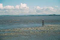 |
See also
References
- ^ a b "Ramsar List" (PDF). Ramsar.org. Retrieved 6 April 2013.
- ^ "The Annotated Ramsar List: United Kingdom". Ramsar.org. Archived from the original on 9 April 2013. Retrieved 6 April 2013.
- v
- t
- e
- Brecon Beacons (Bannau Brycheiniog)
- Snowdonia (Eryri)
- Pembrokeshire Coast National Park
| Proposed |
|---|
- Anglesey
- Clwydian Range and Dee Valley
- Gower
- Llŷn
- Wye Valley (partly in England)
| Proposed |
|---|
- Local nature reserves
- National nature reserves
 Geography
 Wales
Wales Category
 Commons


| |||||||
|---|---|---|---|---|---|---|---|
| Physical |
| ||||||
| Environment | |||||||
| Land use | |||||||
| Administrative |
| ||||||
| Social | |||||||
| Other | |||||||
| |||||||


