Langensoultzbach
You can help expand this article with text translated from the corresponding article in French. (December 2008) Click [show] for important translation instructions.
- View a machine-translated version of the French article.
- Machine translation, like DeepL or Google Translate, is a useful starting point for translations, but translators must revise errors as necessary and confirm that the translation is accurate, rather than simply copy-pasting machine-translated text into the English Wikipedia.
- Do not translate text that appears unreliable or low-quality. If possible, verify the text with references provided in the foreign-language article.
- You must provide copyright attribution in the edit summary accompanying your translation by providing an interlanguage link to the source of your translation. A model attribution edit summary is
Content in this edit is translated from the existing French Wikipedia article at [[:fr:Langensoultzbach]]; see its history for attribution. - You may also add the template
{{Translated|fr|Langensoultzbach}}to the talk page. - For more guidance, see Wikipedia:Translation.
Commune in Grand Est, France
Langensoultzbach Làngesulzbàch | ||
|---|---|---|
Commune | ||
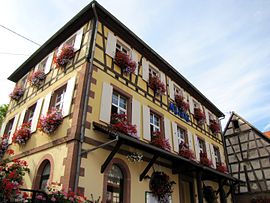 The town hall in Langensoultzbach | ||
 Coat of arms | ||
Location of Langensoultzbach  | ||
(2020–2026) Evelyne Ledig[1] | | |
| Area 1 | 13.09 km2 (5.05 sq mi) | |
| Population (2021)[2] | 911 | |
| • Density | 70/km2 (180/sq mi) | |
| Time zone | UTC+01:00 (CET) | |
| • Summer (DST) | UTC+02:00 (CEST) | |
| INSEE/Postal code | 67259 /67360 | |
| Elevation | 177–411 m (581–1,348 ft) | |
| 1 French Land Register data, which excludes lakes, ponds, glaciers > 1 km2 (0.386 sq mi or 247 acres) and river estuaries. | ||
Langensoultzbach (German: Langensulzbach) is a commune in the Bas-Rhin department in Grand Est in north-eastern France.[3]
The commune is part of the Palatinate Forest-North Vosges Biosphere Reserve.
Geography
The village is some twenty kilometres (twelve miles) to the south-west of Wissembourg and the closest crossings of the Franco-German frontier reachable on a classified road. Slightly more direct and shorter routes to Germany may be available to hikers.
The village is a couple of kilometres from departmental road RD 27, which runs between the villages of Lembach and Wœrth, beyond which it continues to Haguenau. The heart of the village is set in farmland, although most of the surrounding countryside is still made up of woodland.
See also
References
- ^ "Répertoire national des élus: les maires". data.gouv.fr, Plateforme ouverte des données publiques françaises (in French). 2 December 2020.
- ^ "Populations légales 2021". The National Institute of Statistics and Economic Studies. 28 December 2023.
- ^ INSEE commune file
Wikimedia Commons has media related to Langensoultzbach.
- v
- t
- e

- Achenheim
- Adamswiller
- Albé
- Alteckendorf
- Altenheim
- Altorf
- Altwiller
- Andlau
- Artolsheim
- Aschbach
- Asswiller
- Avolsheim
- Baerendorf
- Balbronn
- Baldenheim
- Barembach
- Barr
- Bassemberg
- Batzendorf
- Beinheim
- Bellefosse
- Belmont
- Benfeld
- Berg
- Bergbieten
- Bernardswiller
- Bernardvillé
- Bernolsheim
- Berstett
- Berstheim
- Betschdorf
- Bettwiller
- Biblisheim
- Bietlenheim
- Bilwisheim
- Bindernheim
- Bischheim
- Bischholtz
- Bischoffsheim
- Bischwiller
- Bissert
- Bitschhoffen
- Blaesheim
- Blancherupt
- Blienschwiller
- Bœrsch
- Bœsenbiesen
- Bolsenheim
- Boofzheim
- Bootzheim
- Bosselshausen
- Bossendorf
- Bourg-Bruche
- Bourgheim
- Bouxwiller
- Breitenau
- Breitenbach
- Breuschwickersheim
- La Broque
- Brumath
- Buhl
- Burbach
- Bust
- Buswiller
- Butten
- Châtenois
- Cleebourg
- Climbach
- Colroy-la-Roche
- Cosswiller
- Crastatt
- Crœttwiller
- Dachstein
- Dahlenheim
- Dalhunden
- Dambach
- Dambach-la-Ville
- Dangolsheim
- Daubensand
- Dauendorf
- Dehlingen
- Dettwiller
- Diebolsheim
- Diedendorf
- Dieffenbach-au-Val
- Dieffenbach-lès-Wœrth
- Dieffenthal
- Diemeringen
- Dimbsthal
- Dingsheim
- Dinsheim-sur-Bruche
- Domfessel
- Donnenheim
- Dorlisheim
- Dossenheim-Kochersberg
- Dossenheim-sur-Zinsel
- Drachenbronn-Birlenbach
- Drulingen
- Drusenheim
- Duntzenheim
- Duppigheim
- Durningen
- Durrenbach
- Durstel
- Duttlenheim
- Eberbach-Seltz
- Ebersheim
- Ebersmunster
- Eckartswiller
- Eckbolsheim
- Eckwersheim
- Eichhoffen
- Elsenheim
- Engwiller
- Entzheim
- Epfig
- Erckartswiller
- Ergersheim
- Ernolsheim-Bruche
- Ernolsheim-lès-Saverne
- Erstein
- Eschau
- Eschbach
- Eschbourg
- Eschwiller
- Ettendorf
- Eywiller
- Fegersheim
- Fessenheim-le-Bas
- Flexbourg
- Forstfeld
- Forstheim
- Fort-Louis
- Fouchy
- Fouday
- Friedolsheim
- Friesenheim
- Frœschwiller
- Frohmuhl
- Furchhausen
- Furdenheim
- Gambsheim
- Geispolsheim
- Geiswiller-Zœbersdorf
- Gerstheim
- Gertwiller
- Geudertheim
- Gœrlingen
- Gœrsdorf
- Gottenhouse
- Gottesheim
- Gougenheim
- Goxwiller
- Grandfontaine
- Grassendorf
- Grendelbruch
- Gresswiller
- Gries
- Griesheim-près-Molsheim
- Griesheim-sur-Souffel
- Gumbrechtshoffen
- Gundershoffen
- Gungwiller
- Gunstett
- Haegen
- Haguenausubpr
- Handschuheim
- Hangenbieten
- Harskirchen
- Hatten
- Hattmatt
- Hegeney
- Heidolsheim
- Heiligenberg
- Heiligenstein
- Hengwiller
- Herbitzheim
- Herbsheim
- Herrlisheim
- Hessenheim
- Hilsenheim
- Hindisheim
- Hinsbourg
- Hinsingen
- Hipsheim
- Hirschland
- Hochfelden
- Hochstett
- Hœnheim
- Hœrdt
- Hoffen
- Hohengœft
- Hohfrankenheim
- Le Hohwald
- Holtzheim
- Hunspach
- Hurtigheim
- Huttendorf
- Huttenheim
- Ichtratzheim
- Illkirch-Graffenstaden
- Ingenheim
- Ingolsheim
- Ingwiller
- Innenheim
- Issenhausen
- Ittenheim
- Itterswiller
- Jetterswiller
- Kaltenhouse
- Kauffenheim
- Keffenach
- Kertzfeld
- Keskastel
- Kesseldorf
- Kienheim
- Kilstett
- Kindwiller
- Kintzheim
- Kirchheim
- Kirrberg
- Kirrwiller
- Kleingœft
- Knœrsheim
- Kogenheim
- Kolbsheim
- Krautergersheim
- Krautwiller
- Kriegsheim
- Kurtzenhouse
- Kuttolsheim
- Kutzenhausen
- Lalaye
- Lampertheim
- Lampertsloch
- Landersheim
- Langensoultzbach
- Laubach
- Lauterbourg
- Lembach
- Leutenheim
- Lichtenberg
- Limersheim
- Lingolsheim
- Lipsheim
- Littenheim
- Lixhausen
- Lobsann
- Lochwiller
- Lohr
- Lorentzen
- Lupstein
- Lutzelhouse
- Mackenheim
- Mackwiller
- Maennolsheim
- Maisonsgoutte
- Marckolsheim
- Marlenheim
- Marmoutier
- Matzenheim
- Meistratzheim
- Melsheim
- Memmelshoffen
- Menchhoffen
- Merkwiller-Pechelbronn
- Mertzwiller
- Mietesheim
- Minversheim
- Mittelbergheim
- Mittelhausbergen
- Mittelschaeffolsheim
- Mollkirch
- Molsheimsubpr
- Mommenheim
- Monswiller
- Morsbronn-les-Bains
- Morschwiller
- Mothern
- Muhlbach-sur-Bruche
- Mulhausen
- Munchhausen
- Mundolsheim
- Mussig
- Muttersholtz
- Mutzenhouse
- Mutzig
- Natzwiller
- Neewiller-près-Lauterbourg
- Neubois
- Neugartheim-Ittlenheim
- Neuhaeusel
- Neuve-Église
- Neuviller-la-Roche
- Neuwiller-lès-Saverne
- Niederbronn-les-Bains
- Niederhaslach
- Niederhausbergen
- Niederlauterbach
- Niedermodern
- Niedernai
- Niederrœdern
- Niederschaeffolsheim
- Niedersoultzbach
- Niedersteinbach
- Nordheim
- Nordhouse
- Nothalten
- Obenheim
- Oberbronn
- Oberdorf-Spachbach
- Oberhaslach
- Oberhausbergen
- Oberhoffen-lès-Wissembourg
- Oberhoffen-sur-Moder
- Oberlauterbach
- Obermodern-Zutzendorf
- Obernai
- Oberrœdern
- Oberschaeffolsheim
- Obersoultzbach
- Obersteinbach
- Odratzheim
- Oermingen
- Offendorf
- Offwiller
- Ohlungen
- Ohnenheim
- Olwisheim
- Orschwiller
- Osthoffen
- Osthouse
- Ostwald
- Ottersthal
- Otterswiller
- Ottrott
- Ottwiller
- Petersbach
- La Petite-Pierre
- Pfalzweyer
- Pfulgriesheim
- Plaine
- Plobsheim
- Preuschdorf
- Printzheim
- Puberg
- Quatzenheim
- Rangen
- Ranrupt
- Ratzwiller
- Rauwiller
- Reichsfeld
- Reichshoffen
- Reichstett
- Reinhardsmunster
- Reipertswiller
- Retschwiller
- Reutenbourg
- Rexingen
- Rhinau
- Richtolsheim
- Riedseltz
- Rimsdorf
- Ringendorf
- Rittershoffen
- Rœschwoog
- Rohr
- Rohrwiller
- Romanswiller
- Roppenheim
- Rosenwiller
- Rosheim
- Rossfeld
- Rosteig
- Rothau
- Rothbach
- Rott
- Rottelsheim
- Rountzenheim-Auenheim
- Russ
- Saales
- Saasenheim
- Saessolsheim
- Saint-Blaise-la-Roche
- Saint-Jean-Saverne
- Saint-Martin
- Saint-Maurice
- Saint-Nabor
- Saint-Pierre
- Saint-Pierre-Bois
- Salmbach
- Sand
- Sarre-Union
- Sarrewerden
- Saulxures
- Savernesubpr
- Schaeffersheim
- Schaffhouse-près-Seltz
- Schalkendorf
- Scharrachbergheim-Irmstett
- Scheibenhard
- Scherlenheim
- Scherwiller
- Schillersdorf
- Schiltigheim
- Schirmeck
- Schirrhein
- Schirrhoffen
- Schleithal
- Schnersheim
- Schœnau
- Schœnbourg
- Schœnenbourg
- Schopperten
- Schweighouse-sur-Moder
- Schwenheim
- Schwindratzheim
- Schwobsheim
- Seebach
- Sélestatsubpr
- Seltz
- Sermersheim
- Sessenheim
- Siegen
- Siewiller
- Siltzheim
- Solbach
- Sommerau
- Souffelweyersheim
- Soufflenheim
- Soultz-les-Bains
- Soultz-sous-Forêts
- Sparsbach
- Stattmatten
- Steige
- Steinbourg
- Steinseltz
- Still
- Stotzheim
- Strasbourgpref
- Struth
- Stundwiller
- Stutzheim-Offenheim
- Sundhouse
- Surbourg
- Thal-Drulingen
- Thal-Marmoutier
- Thanvillé
- Tieffenbach
- Traenheim
- Triembach-au-Val
- Trimbach
- Truchtersheim
- Uhlwiller
- Uhrwiller
- Urbeis
- Urmatt
- Uttenheim
- Uttenhoffen
- Uttwiller
- Val-de-Moder
- Valff
- La Vancelle
- Vendenheim
- Villé
- Vœllerdingen
- Volksberg
- Wahlenheim
- Walbourg
- Waldersbach
- Waldhambach
- Waldolwisheim
- Waltenheim-sur-Zorn
- Wangen
- Wangenbourg-Engenthal
- La Wantzenau
- Wasselonne
- Weinbourg
- Weislingen
- Weitbruch
- Weiterswiller
- Westhoffen
- Westhouse
- Westhouse-Marmoutier
- Weyer
- Weyersheim
- Wickersheim-Wilshausen
- Wildersbach
- Willgottheim
- Wilwisheim
- Wimmenau
- Windstein
- Wingen
- Wingen-sur-Moder
- Wingersheim-les-Quatre-Bans
- Wintershouse
- Wintzenbach
- Wintzenheim-Kochersberg
- Wisches
- Wissembourg
- Witternheim
- Wittersheim
- Wittisheim
- Wiwersheim
- Wœrth
- Wolfisheim
- Wolfskirchen
- Wolschheim
- Wolxheim
- Zehnacker
- Zeinheim
- Zellwiller
- Zinswiller
- Zittersheim
- pref: prefecture
- subpr: subprefecture
| Authority control databases: National |
|
|---|
 | This Bas-Rhin geographical article is a stub. You can help Wikipedia by expanding it. |
- v
- t
- e


