Kiwanis Trail
Trail in Michigan
| Kiwanis Trail | |
|---|---|
 | |
| Rails to Trails | |
| Length | 8 miles |
| Location | Adrian to near Tecumseh Michigan Michigan United States United States |
| Trailheads |  Parking in Adrian and north terminus [1][2] Parking in Adrian and north terminus [1][2] |
| Use | Hiking, Bicycling, Inline Skating, Cross Country Skiing[1][3] |
| Grade | mostly flat to gentle railroad grades[4] |
| Difficulty |  Wheelchair accessible[5] Wheelchair accessible[5] |
| Months | 12 |
| Sights | Covered bridge in Trestle Park Trestle bridge over Wolf Creek |
| Surface | Asphalt, Concrete[1] |
| Right of way | DT&I |
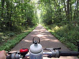
The Kiwanis Trail is a rail to trail conversion in Adrian, Michigan that roughly follows the River Raisin.[1]
History
Map all coordinates using OpenStreetMap
Download coordinates as:
- KML
- GPX (all coordinates)
- GPX (primary coordinates)
- GPX (secondary coordinates)

The trail occupies the old Detroit, Toledo and Ironton Railroad that extended from Ironton, Ohio to Detroit.
The trail forms the first component of a much longer proposed regional greenway trail, the River Raisin Greenway.[6] If completed, it would extend from Adrian to Manchester, Michigan.[1]
Location
The paved trail is maintained by the parks department of in Adrian. It extends northeast and almost reaches the city of Tecumseh.[2]
| Crossing | Mileage | Notes | Coordinates | |
|---|---|---|---|---|
| (mi) | (km) | |||
   Bus. US 223 / M-52 (S. Adrian Hwy. / S. Main St.) Bus. US 223 / M-52 (S. Adrian Hwy. / S. Main St.) | 0 | 0 | Southern Terminus, Adrian | 41°53′28″N 84°02′33″W / 41.891096°N 84.042612°W / 41.891096; -84.042612 (Kiwanis Trail, southern terminus) |
| Riverside Park | 0.3 | 0.48 |  Bathrooms and parking[1][2] Bathrooms and parking[1][2] | 41°53′39″N 84°02′47″W / 41.894112°N 84.046265°W / 41.894112; -84.046265 (Kiwanis Trail, Riverside Park) |
| Bus. US 223 (Maumee St.) | 0.8 | 1.3 | Busy highway crossing | 41°53′58″N 84°02′31″W / 41.899546°N 84.041870°W / 41.899546; -84.041870 (Kiwanis Trail, Business 223) |
| Trestle Park | 1.1 | 1.8 | Bathrooms and parking[1][2] | 41°54′16″N 84°02′09″W / 41.904551°N 84.035880°W / 41.904551; -84.035880 (Kiwanis Trail, Trestle Park) |
| Bent Oak Ave. | 1.7 | 2.7 | Parking[2] | 41°54′34″N 84°02′01″W / 41.909580°N 84.033627°W / 41.909580; -84.033627 (Kiwanis Trail, Bent Oak Ave) |
| Trestle bridge | 1.8 | 2.9 | Trestle bridge over Wolf Creek that drains Lake Adrian into Raisin River | 41°54′34″N 84°02′01″W / 41.909580°N 84.033627°W / 41.909580; -84.033627 (Kiwanis Trail, trestle bridge over Wolf Creek) |
| W. Valley Rd. | 4.2 | 6.8 | Port-a-pot courtesy of St. John's Lutheran Church[2] | 41°56′18″N 84°00′25″W / 41.938298°N 84.007069°W / 41.938298; -84.007069 (Kiwanis Trail, Lutheran church at Valley Rd.) |
| M-52 (N. Adrian Hwy.) | 4.4 | 7.1 | Caution, busy highway | 41°56′29″N 84°00′17″W / 41.941285°N 84.004609°W / 41.941285; -84.004609 (Kiwanis Trail, M-52) |
| Jct. of Ives Rd. & Green Hwy. | 8.1 | 13.0 | Parking,[1] Northern Terminus, 1.5 miles south of Tecumseh | 41°58′41″N 83°57′22″W / 41.978027°N 83.956059°W / 41.978027; -83.956059 (Kiwanis Trail, northern terminus) |
External links
- Traillink: Kiwanis Trail, MI
- Google Maps: Kiwanis Trail, Adrian, MI
- Adrian Kiwanas
References
- ^ a b c d e f g h "Traillink: Kiwanis Trail, MI". Retrieved 4 April 2016.
- ^ a b c d e f "Adrian Lock and Bike: Local Cycling Trail".
- ^ "City of Adrian, Parks Information". Retrieved 4 April 2016.
- ^ "Google Maps: Kiwanis Trail".
- ^ "Michigan Wheelchair Accessible Trails". Retrieved 4 April 2016.
- ^ "Raisin Valley Land Trust: Three River Raisin Projects". Retrieved 4 April 2016.


