Kerama Shotō National Park
Japanese national park
You can help expand this article with text translated from the corresponding article in French. (May 2021) Click [show] for important translation instructions.
- View a machine-translated version of the French article.
- Machine translation, like DeepL or Google Translate, is a useful starting point for translations, but translators must revise errors as necessary and confirm that the translation is accurate, rather than simply copy-pasting machine-translated text into the English Wikipedia.
- Consider adding a topic to this template: there are already 6,211 articles in the main category, and specifying
|topic=will aid in categorization. - Do not translate text that appears unreliable or low-quality. If possible, verify the text with references provided in the foreign-language article.
- You must provide copyright attribution in the edit summary accompanying your translation by providing an interlanguage link to the source of your translation. A model attribution edit summary is
Content in this edit is translated from the existing French Wikipedia article at [[:fr:Parc national de Kerama Shotō]]; see its history for attribution. - You may also add the template
{{Translated|fr|Parc national de Kerama Shotō}}to the talk page. - For more guidance, see Wikipedia:Translation.
Kerama Shotō National Park (慶良間諸島国立公園, Kerama Shotō Kokuritsu Kōen) is a national park in Okinawa Prefecture, Japan. Established in 2014, it is located in and around the Kerama Islands. The park comprises a land area of 3,520 ha (8,700 acres) in the municipalities of Tokashiki and Zamami together with 90,475 ha (223,570 acres) of the surrounding waters. The Kerama Islands previously formed part of Okinawa Kaigan Quasi-National Park. The day of establishment, March 5, coincides with Coral Day (サンゴの日).[1][2][3]
See also
References
- ^ 慶良間諸島国立公園の指定の概要 [Designation of Kerama Shoto National Park - Summary] (PDF) (in Japanese). Ministry of the Environment. Retrieved 5 June 2014.
- ^ "Kerama Islands: new national park in Japan". IUCN. 31 March 2014. Archived from the original on 6 June 2014. Retrieved 5 June 2014.
- ^ 慶良間諸島国立公園の指定について [Concerning the designation of Kerama Shoto National Park] (in Japanese). Okinawa Prefecture. 5 March 2014. Archived from the original on 6 June 2014. Retrieved 5 June 2014.
External links
- (in Japanese) Map of Kerama Shotō National Park
- v
- t
- e
- Akan
- Amami Guntō
- Ashizuri-Uwakai
- Aso-Kujū
- Bandai-Asahi
- Chichibu-Tama-Kai
- Chūbu-Sangaku
- Daisen-Oki
- Daisetsuzan
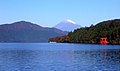
- Fuji-Hakone-Izu
- Hakusan
- Iriomote-Ishigaki
- Ise-Shima
- Jōshinetsu Kōgen
- Kerama Shotō
- Kirishima-Kinkowan
- Kushiro Shitsugen
- Minami Alps
- Myōkō-Togakushi Renzan
- Nikkō
- Ogasawara
- Oze
- Rishiri-Rebun-Sarobetsu
- Saikai
- Sanin Kaigan
- Sanriku Fukkō
- Setonaikai
- Shikotsu-Tōya
- Shiretoko
- Towada-Hachimantai
- Unzen-Amakusa
- Yanbaru
- Yakushima
- Yoshino-Kumano
- Abashiri
- Aichi Kōgen
- Akiyoshidai
- Biwako
- Chōkai
- Echigo Sanzan-Tadami
- Echizen-Kaga Kaigan
- Genkai
- Hayachine
- Hiba-Dōgo-Taishaku
- Hida-Kisogawa
- Hidaka-sanmyaku Erimo
- Hyōnosen-Ushiroyama-Nagisan
- Ibi-Sekigahara-Yōrō
- Iki-Tsushima
- Ishizuchi
- Kita Nagato
- Kitakyūshū
- Kongō-Ikoma-Kisen
- Kōya-Ryūjin
- Kurikoma
- Kyoto Tamba Kōgen
- Kyūshū Chūō Sanchi
- Meiji no Mori Minō
- Meiji no Mori Takao
- Mikawa Wan
- Minami Bōsō
- Minami Sanriku Kinkasan
- Murō-Akame-Aoyama
- Muroto-Anan Kaigan
- Myōgi-Arafune-Saku Kōgen
- Nichinan Kaigan
- Nippō Kaigan
- Niseko-Shakotan-Otaru Kaigan
- Nishi-Chūgoku Sanchi
- Noto Hantō
- Oga
- Okinawa Kaigan
- Okinawa Senseki
- Ōnuma
- Sado-Yahiko-Yoneyama
- Shimokita Hantō
- Shokanbetsu-Teuri-Yagishiri
- Sobo Katamuki
- Suigō-Tsukuba
- Suzuka
- Tango-Amanohashidate-Ōeyama
- Tanzawa-Ōyama
- Tenryū-Okumikawa
- Tsugaru
- Tsurugisan
- Wakasa Wan
- Yaba-Hita-Hikosan
- Yamato-Aogaki
- Yatsugatake-Chūshin Kōgen
- Zaō
 | This Okinawa Prefecture location article is a stub. You can help Wikipedia by expanding it. |
- v
- t
- e
 | This article about a national/quasi-national park or protected area in Japan, or related topic is a stub. You can help Wikipedia by expanding it. |
- v
- t
- e


