Kayapat
Village in West Bengal, India
22°54′16″N 87°32′17″E / 22.904523°N 87.538172°E / 22.904523; 87.538172 India
India (2011)
712122
Kayapat is a village in the Goghat II CD block in the Arambagh subdivision of Hooghly district in the Indian state of West Bengal.
Geography


8km
5miles
5miles
Damodar
River
River
Rupnarayan
River
River
Mundeswari
River
River
Dwarakeswar
River
River
Shyambazar
H

Satberia
H
Parul
H
Memanpur
H
Mamudpur
H
Madhabpur
H
Kanpur
HV
Kayapat
H
Hat Basantapur
H
Hamirbati
H
Gourhati
H
Fului
H
Dihi
Bayara
Bayara
H
Bhalia
H
Bali Dewanganj
H
Badanganj
H
Gar Mandaran
H
Arambag
M
Dakshin Narayanpur
R
Natibpur
R
Shrirampur
R
Radhanagore
R
Keshabpur
R
Bengai
R
Pursurah
R
Kamarpukur
R
Khanakul
R
Goghat
R
Cities and towns in Arambagh subdivision in Hooghly district
M: municipal city/ town, R: rural/ urban centre, H: historical/ religious centre
Owing to space constraints in the small map, the actual locations in a larger map may vary slightly
M: municipal city/ town, R: rural/ urban centre, H: historical/ religious centre
Owing to space constraints in the small map, the actual locations in a larger map may vary slightly
Area overview
The Arambagh subdivision, presented in the map alongside, is divided into two physiographic parts – the Dwarakeswar River being the dividing line. The western part is upland and rocky – it is extension of the terrain of neighbouring Bankura district. The eastern part is flat alluvial plain area. The railways, the roads and flood-control measures have had an impact on the area.[1] The area is overwhelmingly rural with 94.77% of the population living in rural areas and the remaining 5.23% living in urban areas.[2]
Note: The map alongside presents some of the notable locations in the subdivision. All places marked in the map are linked in the larger full screen map.
Location
Kayapat is located at 22°54′16″N 87°32′17″E / 22.904523°N 87.538172°E / 22.904523; 87.538172
Demographics
As per the 2011 Census of India, Kayapat had a total population of 3,351 of which 1,737 (52%) were males and 1,614 (48%) were females. Population in the age range 0–6 years was 340. The total number of literate persons in Kayapat was 2,578 (85.62% of the population over 6 years).[3]
Culture
David J. McCutchion mentions the Sridhara temple of Mondal family as having been built in 1807 as a nava ratna with rich terracotta façade. He also mentions a pancha ratna temple with terracotta decoration.[4]
Kayapat picture gallery
-
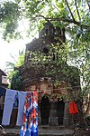 Sridhar Laljiu temple of Mondal family, built in 1807 (front side).
 -
 Sridhar Laljiu temple built as a nava ratna temple, now in a ruinous condition (rear side).
 -
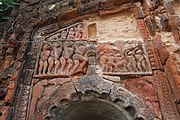 Crumbling terracotta designs at Sridhar Laljiu temple
 -
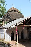 At chala temple adjacent to Sridhar Laljiu temple


References
- ^ "District Census Handbook: Hugli, Series-20, Part XIIA" (PDF). Physiography, Page 17-19. Directorate of Census Operations, West Bengal, 2011. Retrieved 25 September 2020.
- ^ "District Statistical Handbook 2014 Hooghly". Table 2.2, 2.4(a). Department of Planning and Statistics, Government of West Bengal. Retrieved 25 September 2020.
- ^ "2011 Census – Primary Census Abstract Data Tables". West Bengal – District-wise. Registrar General and Census Commissioner, India. Retrieved 22 September 2020.
- ^ McCutchion, David J., Late Mediaeval Temples of Bengal, first published 1972, reprinted 2017, pages 46, 52. The Asiatic Society, Kolkata, ISBN 978-93-81574-65-2
- v
- t
- e
Cities, towns and locations in Hooghly district
municipalities
and
census towns
other than
cities and towns
 Hooghly topics
- Template:Srirampore subdivision
 People from Hooghly district
- Villages in Hooghly district


 India portal


