Herent
Municipality in Flemish Community, Belgium

Flag

Coat of arms
Location of Herent


Herent
Location in Belgium 
Location of Herent in Flemish Brabant

 Belgium
 (2018-01-01)[1]
3020
24038
Herent (Dutch pronunciation: [ˈɦeːrənt]) is a municipality located in the Belgian province of Flemish Brabant. The municipality comprises the villages and former municipalities of Herent proper, Veltem-Beisem and Winksele. On January 1, 2016, Herent had a total population of 21,213. The total area is 32.73 km² resulting in a population density of 648 inhabitants per km². The current mayor (as of 2018) is Astrid Pollers.
Schools
- Catholic schools: De Kraal & Pastoor De Clerckschool[2]
- Public Schools: De Bijenkorf (Flemish Community) & Toverveld (municipal)[2]
Image gallery
-
 Church in the centre of Herent
 -
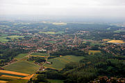 Aerial view of Veltem-Beisem


References
- ^ "Wettelijke Bevolking per gemeente op 1 januari 2018". Statbel. Retrieved 9 March 2019.
- ^ a b "Scholen in Herent".
External links
 Media related to Herent at Wikimedia Commons
- Official website - Available only in Dutch
Places adjacent to Herent | ||||||||||||||||
|---|---|---|---|---|---|---|---|---|---|---|---|---|---|---|---|---|
| ||||||||||||||||


- v
- t
- e
- Affligem
- Asse
- Beersel
- Bever
- Dilbeek
- Drogenbos
- Galmaarden
- Gooik
- Grimbergen
- Halle
- Herne
- Hoeilaart
- Kampenhout
- Kapelle-op-den-Bos
- Kraainem
- Lennik
- Liedekerke
- Linkebeek
- Londerzeel
- Machelen
- Meise
- Merchtem
- Opwijk
- Overijse
- Pepingen
- Roosdaal
- Sint-Genesius-Rode
- Sint-Pieters-Leeuw
- Steenokkerzeel
- Ternat
- Vilvoorde
- Wemmel
- Wezembeek-Oppem
- Zaventem
- Zemst

- Bold indicates cities
- Italic indicates municipalities with language facilities
Authority control databases | |
|---|---|
| International |
|
| National |
|
| Geographic |
|
 | This Flemish Brabant location article is a stub. You can help Wikipedia by expanding it. |
- v
- t
- e


