Helderberg Escarpment
Mountain in New York, United States


Helderberg Escarpment
Location of the Helderberg Escarpment within New York
Show map of New York Adirondack Park
Helderberg Escarpment
Helderberg Escarpment (the United States)
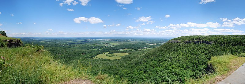
Show map of the United StatesThe Helderberg Escarpment, also known as the Helderberg Mountains, is an escarpment in eastern New York, United States, roughly 11 miles (18 km) west of the city of Albany.[2][3] The escarpment is the northeastern extremity of the Allegheny Plateau. It rises steeply from the Hudson Valley below, with an elevation difference of approximately 700 feet (from 400 to 1,100 feet) over a horizontal distance of approximately 2,000 feet. Much of the escarpment is within John Boyd Thacher State Park, and has views of the Hudson Valley and the Capital District.
Geology

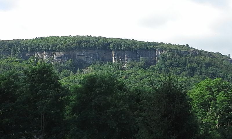
The escarpment is part of the Onondaga Escarpment and is geologically related to the Niagara Escarpment, and the Black River Escarpment.[4] The rocks exposed in the escarpment date back to the Middle Ordovician to Early Devonian.
In 1934 the Schenectady Gazette described how the Tory Cave, one of the limestone caves to be found in the escarpment, routinely had stalagmites of ice in the springtime.[5]
Transmission towers
Most of the Capital District's television and FM radio stations installed their transmission towers at the escarpment to take advantage of its high ground.[6] In 2003 a 499-foot (152 m) tower was built on the highest point of the escarpment, for transmitting digital television and FM radio signals.[7]
History
Dutch settlers first homesteaded the plateau above the escarpment in the 17th century.[8][9] Helleberg is a Dutch name meaning "clear mountain".[10]
The Open Space Institute and the Mohawk Hudson Land Conservancy are working to keep escarpment lands from being developed for housing or industrial uses.[11] Farmers farming land near the escarpment can apply to sell their development rights, to help make sure that land is not developed. In 2003 the Ten Eyck family, owners of the Indian Ladder Farm just below the escarpment, sold the development rights to their farm for $848,000. Two real estate assessment were done, one on the value of the property as a working farm, the other on its value as a potential site for urban development. The Ten Eycks were paid the difference in return for agreeing to keep the property as a working farm. They were the first property owners to sell their development rights in Albany County.
References
Wikimedia Commons has media related to Helderberg Escarpment.
- ^ "Helderberg Mountains". Geographic Names Information System. United States Geological Survey, United States Department of the Interior. Retrieved 2018-04-05.
- ^ "Significant Habitats and Habit Complexes of the New York Bight Watershed: Helderberg Escarpment". United States Fish and Wildlife Service. Retrieved 2010-12-01.
- ^ "Helderberg Escarpment List of Species of Special Emphasis". United States Fish and Wildlife Service. Retrieved 2010-12-01.
- ^ "North Estonian Klint and some of its analogues". 2008. Archived from the original on 2014-06-22. Retrieved 2013-08-01.
Helderberg Escarpment in Albany County, New York State, is up to 300 m high and traceable over more than 100 km. The escarpment exposes rock complexes from a nearly 70-million-year time period (Middle Ordovician to Early Devonian), representing a moderate-grade slope in which harder Coeymans (Devonian) and Onondaga (Silurian) limestones are distinguishable as escarpments a few dozen metres in height.
- ^ "Icy Stalagmites in Tory Cave". Schenectady Gazette. 1934-03-30. Retrieved 2013-08-01 – via Google News Archive.
- ^ FCC Registered Broadcast Land Mobile Towers in New Scotland, NY, http://www.city-data.com/towers/lmobile-New-Scotland-New-York.html
- ^ Philip Schwartz (2005-02-20). "Area stations share a Helderberg tower". Daily Gazette (Schenectady). Retrieved 2013-08-01.
In late 2003, a single, 499-foot transmission tower went up on the Helderberg escarpment in the Town of New Scotland, just outside Albany at the highest point in the immediate area.
- ^ John K. Elberfeld, Jane B. McLean (2012). Helderberg Hilltowns. Arcadia Publishing. ISBN 9780738592688.
- ^ O. D. von Engeln (1988). "The Finger Lakes Region: Its Origin and Nature". Cornell University Press. ISBN 9780801495014. Retrieved 2013-08-01.
- ^ Gannett, Henry (1905). The Origin of Certain Place Names in the United States. Govt. Print. Off. pp. 154.
- ^ Jill Bryce (2003-05-16). "New Scotland Orchard protected from development". Daily Gazette (Schenectady). pp. 1, 4. Retrieved 2013-08-01 – via Google News Archive.
- v
- t
- e
Hudson River watershed
- Batavia Kill
- Batten Kill
- Birch Creek
- Black Meadow Creek
- Boreas River
- Bowery Creek
- Bowmans Creek
- Breakneck Brook
- Brimstone Creek
- Canajoharie Creek
- Caroga Creek
- Casperkill
- Catskill Creek
- Cayadutta Creek
- Cedar River
- Claverack Creek
- Clove Brook
- Cobleskill Creek
- Coeymans Creek
- Coxsackie Creek
- Cross River
- Croton River
- East Branch Croton River
- East Branch Sacandaga River
- East Canada Creek
- East Kill
- Eightmile Creek
- Esopus Creek
- Fall Kill
- Fishkill Creek
- Fonteyn Kill
- Fulmer Creek
- Hannacrois Creek
- Honnedaga Brook
- Hoosic River
- Indian River
- Jackson Creek
- Jan De Bakkers Kill
- Kaaterskill Creek
- Kayaderosseras
- Kinderhook Creek
- Kisco River
- Lake Creek
- Little Shawangunk Kill
- Maritje Kill
- Miami River
- Mill Creek
- Mohawk River
- Moodna Creek
- Moordener Kill
- Moyer Creek
- Muddy Kill
- Neepaulakating Creek
- Normans Kill
- Nowadaga Creek
- Ohisa Creek
- Onesquethaw Creek
- Opalescent River
- Oriskany Creek
- Otsquago Creek
- Otter Kill
- Papakating Creek
- Peekskill Hollow Creek
- Plattekill Creek
- Platter Kill
- Pocantico River
- Pochuck Creek
- Poesten Kill
- Potic Creek
- Quassaick Creek
- Roeliff Jansen Kill
- Rondout Creek
- Sacandaga River
- Sauquoit Creek
- Saw Kill
- Saw Mill River
- Sawyer Kill
- Schoharie Creek
- Schroon River
- Shawangunk Kill
- Sparkill Creek
- Sprout Creek
- Steele Creek
- Stockport Creek
- Stony Clove Creek
- Taghkanic Creek
- Tenmile Creek
- Tin Brook
- Titicus River
- Verkeerder Kill
- Vloman Kill
- Wallkill River
- Walloomsac River
- Wappinger Creek
- Wawayanda Creek
- West Branch Papakating Creek
- West Branch Sacandaga River
- West Canada Creek
- West Kill
- Wynants Kill
- Alcove Reservoir
- Ashokan Reservoir
- Basic Creek Reservoir
- Beacon Reservoir
- Bog Brook Reservoir
- Cedar Lake
- Chadwick Lake
- Chub Lake
- Cross River Reservoir
- Croton Falls Reservoir
- Dyken Pond
- East Branch Reservoir
- East Caroga Lake
- Fall Lake
- Franklinton Vlaie
- Garnet Lake
- Glenmere Lake
- Great Sacandaga Lake
- Great Vlaie
- Henderson Lake
- Honnedaga Lake
- Indian Lake
- Lizard Pond
- Lake Maratanza
- Muscoot Reservoir
- Lake Neepaulin
- New Croton Reservoir
- Notch Lake
- Piseco Lake
- Lake Pleasant
- Queechy Lake
- Rondout Reservoir
- Sacandaga Lake
- Saratoga Lake
- Sturgeon Pool
- Surprise Lake
- Sylvan Lake
- Lake Tear of the Clouds
- Thompson Pond
- Titicus Reservoir
- Trout Lake
- West Caroga Lake
- Whaley Lake
- Winnisook Lake
| New York |
|
|---|---|
| New Jersey |
- Adirondack Mountains
- Adirondack Park
- Ashokan Bridge
- Blenheim Bridge
- Buskirk Bridge
- Catskill Mountains
- Champlain Canal
- Cohoes Falls
- Copeland Bridge
- Delaware and Hudson Canal
- Eagleville Bridge
- East River
- Erie Canal
- George Washington Bridge
- Harlem River
- Helderberg Escarpment
- Holland Tunnel
- Hudson Highlands State Park
- Kaaterskill Clove
- Kaaterskill Falls
- Kill Van Kull
- Kingston–Rhinecliff Bridge
- Lincoln Tunnel
- Mid-Hudson Bridge
- Newburgh–Beacon Bridge
- Tappan Zee Bridge (2017–present)
- The Palisades
- Perrine's Bridge
- Plotter Kill Preserve
- Pollepel Island
- Popolopen
- Rexleigh Bridge
- Rip Van Winkle Bridge
- Salisbury Center Bridge
- Schoharie Bridge
- Shushan Bridge
- Statue of Liberty
- Taconic Mountains
- Verkeerder Kill Falls
- Walkway over the Hudson
- Wallkill River National Wildlife Refuge
- West Canada Lake Wilderness Area
| Authority control databases: National |
|
|---|
 | This article about a location in Albany County, New York is a stub. You can help Wikipedia by expanding it. |
- v
- t
- e


