Heer, Maastricht
Neighbourhood & former municipality in Netherlands, Limburg, Maastricht
Heer | |
|---|---|
neighbourhood & former municipality | |
 Location of Amby in Maastricht | |
| Municipality | Maastricht |
| Province | Limburg |
| Country | Netherlands |
| Population | |
| • Total | 7,615 |
Heer is a neighbourhood of Maastricht, in the Dutch province of Limburg. Heer is a former municipality and village, incorporated into Maastricht in 1970 and, until 1828, this municipality was called "Heer en Keer".[1] The municipality covered the former villages of Heer and Scharn. It is located on the right bank of the river Meuse.
Impressions
-
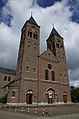 National monument 506637, St Petrus Banden Church
 -
 National monument 506693, chapel of the Opveld convent


References
- ^ Ad van der Meer and Onno Boonstra, Repertorium van Nederlandse gemeenten, KNAW, 2011.
Neighbouring areas | ||||||||||||||||
|---|---|---|---|---|---|---|---|---|---|---|---|---|---|---|---|---|
| ||||||||||||||||


- v
- t
- e
| General |
|
|---|---|
| Education |
|
| History |
|

| Geology & Hydrology |
|
|---|---|
| Region / Urban area |
|
| Neighbourhoods |
|
| Local politics |
|
|---|---|
| International politics |
- A2 motorway
- Maastricht Aachen Airport (shared with Aachen, Germany)
- Maastricht railway station
- Maastricht Noord railway station
- Maastricht Randwyck railway station
- Hasselt – Maastricht tramway (cancelled)


| Authority control databases |
|
|---|
50°50′26″N 5°43′37″E / 50.84056°N 5.72694°E / 50.84056; 5.72694
 | This Dutch Limburg location article is a stub. You can help Wikipedia by expanding it. |
- v
- t
- e


