Emmental Alps
Mountain range of the Alps in central Switzerland
46°47′13″N 8°02′49″E / 46.78694°N 8.04694°E / 46.78694; 8.04694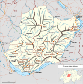
The Emmental Alps (German: Emmentaler Alpen) are a mountain range in the western part of the Alps, in Switzerland. They are located north-west of the Brünig Pass, mainly in the cantons of Lucerne, Bern, and Obwalden, with a small portion in the canton of Nidwalden. The highest summit of the range is the Brienzer Rothorn, which is also the highest point in the canton of Lucerne. The range is named after the Emme valley (German: Emmental). In the north-west corner one finds the relatively low, but widespread, and very furrowed Napf.
The Emmental Alps are separated from the Bernese Alps by the Aare valley to the south and connected to the Uri Alps by the four lakes Lungerersee, Sarnersee, Wichelsee, and Vierwaldstättersee to the east.
Notable peaks
- Brienzer Rothorn (2,350 m)
- Tannhorn (2,221 m)
- Arnihaaggen (2,207 m)
- Höch Gumme (2,205 m)
- Hohgant (2,197 m)
- Augstmatthorn (2,137 m)
- Pilatus (2,128 m)
- Schrattenfluh (2,092 m)
- Widderfeld (2,076 m)
- Burgfeldstand (2,063 m)
- Sigriswiler Rothorn (2,051 m)
- Fürstein (2,040 m)
- Wilerhorn (2,005 m)
- Schafmatt (1,979 m)
- Niederhorn (1,963 m)
- Sieben Hengste (1,955 m)
- Haglere (1,949 m)
- Mittaggüpfi (1,917 m)
- Schimbrig (1,815 m)
- Honegg (1,546 m)
- Wachthubel (1,415 m)
- Napf (1,408 m)
References
- Charles Knapp, Maurice Borel, Victor Attinger, Heinrich Brunner, Société neuchâteloise de géographie: Geographisches Lexikon der Schweiz. Volume 1: Aa - Emmengruppe. Gebrüder Attinger, Neuchâtel 1902, pp. 701–704 (Scan of the page)
External links
![]() Media related to Emmental Alps at Wikimedia Commons
Media related to Emmental Alps at Wikimedia Commons
| Authority control databases |
|
|---|


