Districts of Suriname
Administrative divisions in Suriname
Politics of Suriname |
|---|
 |
| Constitution |
| Government
|
| Legislature
|
| Judiciary |
|
| Elections
|
| |
 Suriname portal Suriname portal |
|
Suriname is divided into 10 districts (Dutch: districten).
Overview

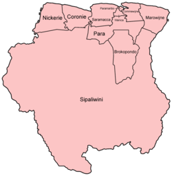
Regions of Suriname by number and name
| District | Capital | Area (km2) | Area (%) | Population (2012 census)[1] | Population (%) | Pop. dens. (inhabitants/km2) | |
|---|---|---|---|---|---|---|---|
| Suriname | Paramaribo | 163,820 | 100.0 | 541,638 | 100.0 | 3.3 | |
| 1 | Brokopondo | Brokopondo | 7,364 | 4.5 | 15,909 | 2.9 | 2.2 |
| 2 | Commewijne | Nieuw-Amsterdam | 2,353 | 1.4 | 31,420 | 5.8 | 13.4 |
| 3 | Coronie | Totness | 3,902 | 2.2 | 3,391 | 0.6 | 0.9 |
| 4 | Marowijne | Albina | 4,627 | 2.8 | 18,294 | 3.4 | 4.0 |
| 5 | Nickerie | Nieuw-Nickerie | 5,353 | 3.3 | 34,233 | 6.3 | 6.4 |
| 6 | Para | Onverwacht | 5,393 | 3.3 | 24,700 | 4.6 | 4.6 |
| 7 | Paramaribo | Paramaribo | 182 | 0.1 | 240,924 | 44.5 | 1323.8 |
| 8 | Saramacca | Groningen | 3,636 | 2.2 | 17,480 | 3.2 | 4.8 |
| 9 | Sipaliwini | none | 130,567 | 79.7 | 37,065 | 6.8 | 0.3 |
| 10 | Wanica | Lelydorp | 443 | 0.3 | 118,222 | 21.8 | 266.9 |
History
The country was first divided up into subdivisions by the Dutch on October 8, 1834, when a Royal Decree declared that there were to be 8 divisions and 2 districts:[2]
- Upper Suriname and Torarica
- Para
- Upper Commewijne
- Upper Cottica and Perica
- Lower Commewijne
- Lower Cottica
- Matapica
- Saramacca
- Coronie (district)
- Nickerie (district)
The divisions were areas near the capital city, Paramaribo, and the districts were areas further away from the city.
-
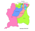 Suriname districts 1914-1917
 -
 Suriname districts 1958-1967
 -
 Suriname districts 1968-1985


In 1927, Suriname's districts were revised, and the country was divided into 7 districts. In 1943, 1948, 1949, 1952 and 1959 further small modifications were made. In 1968 the districts were redrawn again, into[3]
- Nickerie
- Coronie
- Saramacca
- Brokopondo
- Para
- Suriname
- Paramaribo
- Commewijne
- Marowijne
These divisions remained until 1980, when yet again, the borders of the districts were redrawn, however, with the following requirements:
- Changes in the old boundaries were made only if it leads to improved functioning
- Each area should be developed
- The new boundaries should respect the identities of indigenous people.
The last changes to the districts were in 1985.[3]
See also
References
External links
- "Districts of Suriname". Statoids.


Administrative divisions of the Americas | ||
|---|---|---|
| ||
|  | |
| Sovereign states |
| |
| ||
 | This Suriname location article is a stub. You can help Wikipedia by expanding it. |
- v
- t
- e


