Broom Hill, London
Human settlement in England
- London
- Bexley and Bromley
Broom Hill, sometimes spelt Broomhill,[1] is a suburb of Orpington in southeast London, England, located in the London Borough of Bromley in Greater London. Prior to 1965 it was within the historic county of Kent. It lies south of Poverest, west of Orpington High Street, north-east of Crofton, and south-east of Petts Wood.
History
Broom Hill takes its name from a shrub located on the hill that was used to make brooms.[1] It was historically a rural locality, noted only for its broom and bonnet-making industries.[1] In 1819 a Zion Chapel was built on Devonshire Road, however this was later converted to cottages and then the cottages torn down in 1935.[1] In the early 20th century housing development began in the southern part of the area, including a golf course, to cater for commuters using Orpington railway station.[1] Further development occurred, and the golf course was built over, with the area losing its rural character completely and merging into Orpington and the surrounding suburbs.[1]
Nowadays the area essentially forms a western suburb of Orpington, centred on Broom Hill Common, which is protected under the Commons Preservation Act 1965.[2] There is one pub - The Cricketers - located here,[3] a very small row of shops on Fordwich Close, and further shops lining Chislehurst Road.
Notable people
- Malcolm Campbell (1885-1948) - British racing motorist who set the world speed record on land and on water in the 1920-30s, practised flying from Broom Hill in the 1910s.[1][4]
Gallery
-
 Broom Hill Common
 -
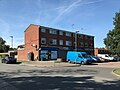 Shops on Fordwich Close
 -
 The Cricketers pub
 -
 Broom Hill Common from Broomhill Road
 -
 Shops on Chislehurst Road
 -
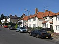 Typical suburban housing of the area


References
- ^ a b c d e f g Willey, Russ (2006). The London Gazetteer. Chambers Harrap Publishers Ltd. p. 66.
- ^ "Broom Hill Common Local Open Space". London Gardens Trust. Retrieved 29 September 2020.
- ^ "The Cricketers Knoll". Pubs Galore. Retrieved 29 September 2020.
- ^ "Orpington Airfield". UK Airfield Guide. Retrieved 29 September 2020.
- v
- t
- e
- Anerley
- Aperfield
- Beckenham
- Berry's Green
- Bickley
- Biggin Hill
- Bromley
- Bromley Common
- Chelsfield
- Chislehurst
- Coney Hall
- Crystal Palace
- Cudham
- Downe
- Eden Park
- Elmers End (including Upper Elmers End)
- Elmstead
- Farnborough
- Foxbury
- Goddington
- Green Street Green
- Hayes
- Hazelwood
- Hockenden
- Horns Green
- Keston
- Kevington
- Leaves Green
- Locksbottom
- Longlands
- Luxted
- Mottingham
- New Beckenham
- Orpington (including: Broom Hill, Crofton, Derry Downs and Ramsden)
- Park Langley
- Penge
- Petts Wood
- Plaistow
- Poverest
- Pratt's Bottom
- Ruxley
- St Mary Cray
- St Paul's Cray
- Shortlands
- Single Street
- Southborough
- South Street
- Sundridge
- Sydenham
- Upper Norwood
- West Wickham
- Widmore


- Betts Park
- Chislehurst Common
- Crofton Wood
- Croydon Road Recreation Ground
- Crystal Palace Park
- Cuckoo Wood
- Downe Bank
- Elmstead Wood
- Hayes Common
- High Elms Country Park
- Jubilee Country Park
- Kelsey Park
- Keston Common
- Norman Park
- Ruxley Gravel Pits
- Saltbox Hill
- Scadbury Park
- Sundridge Park
- The Warren
- West Kent Golf Course nature reserve
- Beckenham
- Bromley and Chislehurst
- Lewisham West and Penge
- Orpington
tram stops

 Anerley
 Avenue Road
- Beckenham Road
- Beckenham Junction
- Bickley
- Birkbeck
- Bromley North
- Bromley South
- Chelsfield
- Chislehurst
- Clock House
- Crystal Palace
- Eden Park
- Elmers End
- Elmstead Woods
- Hayes
- Kent House
- Knockholt
- Lower Sydenham
- New Beckenham
- Orpington
- Penge East
- Penge West
- Petts Wood
- Ravensbourne
- St Mary Cray
- Shortlands
- Sundridge Park
- West Wickham


 Category
 Commons


