Beni-Chougrane


Beni-Chougrane Range
Algeria
The Beni-Chougrane Range (Arabic: جبال بني شقران, French: Monts des Beni-Chougrane) is a mountain range in the northwest of Algeria, part of the Atlas Mountain System.
Geography
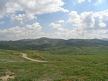
The mountains of Beni-Chougrane belong to the Tell Atlas chain located between the Plain of Habra-Sig in the north and the Plain of Ghriss in the south.[2] They are characterized by a Mediterranean climate and a semi-arid terrain, which promotes erosion. The range's average altitude is 700 m and rises to 932 m in the vicinity of El Bordj.
Several dams are located in the mountain range. as well as rich plains and major wadis such as El Hammam and Fergoug. The area is currently undergoing reforestation.[3] The total area is 1618 km2 or 32% of the area of Mascara wilaya.
See also
References
- ^ Google Earth
- ^ Monographie de la wilaya de Mascara, sur le site de la Chambre Algérienne de Commerce et d'Industrie Archived December 11, 2011, at the Wayback Machine
- ^ Marc Côte, Guide d'Algérie : paysages et patrimoine, Média-Plus, 1996, 319 p. (ISBN 9961-922-00-X), p. 69
- v
- t
- e

- Blidean Atlas
- Babor Mountains
- Beni-Chougrane
- Bibans
- Bouzegza Mount [ar]
- Constantine Mountains
- Chenoua Mount
- Dahra Range
- Djurdjura
- Edough
- Khachna
- Kroumirie
- Ouarsenis
- Medjerda Mountains
- Murdjajo
- Numidian Range
- Saïda Mountains
- Tlemcen Mountains
- Titteri
- Tessala Range
- Trara
- Yemma Gouraya
- Amour Range
- Aurès Mountains
- Belezma Range
- Hodna Mountains
- Ksour Range
- Ouled Naïl Range
- Nememcha Range
- Zab Mountains
- Achaoun
- Anneb
- Djebel Antar
- Djebel Azao
- Djebel Chélia
- Djebel Grouz
- Djebel Guetiane
- Djebel Tsili
- Koudiat Béni Arif
- Koudiat Sidi Abdelkader
- Lalla Khedidja
- Maouna
- Mount Babor
- Mount Bissa
- Mount Issa
- Mount Tahat
- Mount Tamgout
- Mount Zaccar
- Pic des Singes
- Taourirt Tan Afella
- Thaletat


