Battery Rodgers
38°47′43″N 77°02′36″W / 38.795167°N 77.0433°W / 38.795167; -77.0433Site information Condition demolished Site history Built 1863 (1863) In use 1863–1865 Materials earth 
Battery Rodgers was a gun emplacement that composed a portion of the American Civil War defenses of the American capital city of Washington, D.C.
Construction
Built in 1863, Battery Rodgers was constructed with the ability to interdict sea traffic sailing up the Potomac River to Washington, D.C.. From its position on a 28-foot (8.5 m) high cliff overlooking Battery Cove, it was positioned with a clear view of fire and was ably suited to guarding the southern Potomac River and Accotink Road (Fort Hunt Road) approaches to Washington. The battery was named for George W. Rodgers, a captain in the Union Navy who was killed during an attack on Fort Wagner.[1]
It was 185 feet (56 m) long with sides of 60 and 80 feet (18 and 24 m).[2] During the war, the battery mounted one 6.4-inch (160 mm) (100-pounder, 45 kg) Parrott rifle and one 15-inch (380 mm) Rodman gun, one of the largest guns in the world at that time. The guns were supplied by two adjacent powder magazines, and the battery complex included a hospital, barracks, mess hall, and prison. It was garrisoned by 6 commissioned officers, 1 ordnance sergeant, and 256 men. Following the conclusion of the war, the Battery was disbanded and its guns were removed to other locations in Washington. The land on which the battery rested was sold soon afterward, due in no small part to its location in the center of Alexandria, Virginia.
Today, no portion of the battery still stands, but it is memorialized by a small marker in Alexandria, at the intersection of South Lee Street and Green Street and the corner of Jones Point Park. The Rodman gun used at the battery was moved across the Potomac to Fort Foote, and can still be seen there today.
-
 View of Battery Rodgers with 8-inch (200 pdr) Parrott rifle in front and 15-inch Rodman gun behind.
 -
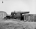 A 15-inch Rodman gun in Battery Rodgers.
 -
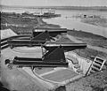
 Another view of Battery Rodgers showing the 8-inch (200 pdr) Parrott rifle and the 15-inch Rodman gun.
 -
 One of the dug-in ammunition magazines at Battery Rodgers.
 -
 The site of Battery Rodgers in 2009


Notes
References
- "Out of the Attic: Battery Rodgers". The Alexandria Times. Alexandria, Virginia. 3 June 2010.
- Cooling III, Benjamin Franklin; Owen II, Walton H. (6 October 2009). Mr. Lincoln's Forts: A Guide to the Civil War Defenses of Washington. Scarecrow Press. ISBN 978-0-8108-6307-1.
- Howe, A.P. (1891). "Report from Headquarters, Inspector of Artillery, May 17, 1864". The War of the Rebellion: A Compilation of the Official Records of the Union and Confederate Armies, Series I. XXXVI (II). Washington, D.C.: Government Printing Office: 883–897. Retrieved 2007-11-25.
External links
Wikimedia Commons has media related to Battery Rodgers.
- Alexandria Archeology, Battery Rodgers
- Battery Rodgers Marker – Historical Marker Database
- v
- t
- e
American Civil War Defenses of Washington, D.C.
- Department of the East
- Department of Washington, D.C.
- Department of the Potomac
- Military District of Washington
- Department of the Rappahanock
- Defenses of Washington, D.C.
- Department of Washington
- Army of the Potomac
- XXII Corps
- Fort Washington (MD)
- Fort Foote (MD)
- Battery Rodgers (VA)
- Fort Marcy
- Fort Ethan Allen
- Fort C. F. Smith
- Fort Bennett
- Fort Strong
- Fort Corcoran
- Fort Haggerty
- Fort Morton
- Fort Woodbury
- Fort Cass
- Fort Whipple
- Fort Tillinghast
- Fort McPherson
- Fort Buffalo
- Fort Ramsay
- Fort Craig
- Fort Albany
- Fort Jackson
- Fort Runyon
- Fort Richardson
- Fort Barnard
- Fort Berry
- Fort Scott
- Battery Garesche
- Fort Reynolds
- Fort Ward
- Fort Worth
- Fort Williams
- Fort Ellsworth
- Fort Lyon
- Fort Farnsworth
- Fort Weed
- Fort O'Rourke
- Fort Willard
- Fort Cross (MD)
- Fort Kirby (MD)
- Fort Sumner (MD)
- Battery Alexander (MD)
- Fort Simmons (MD)
- Fort Davis (MD)
- Battery Benson (MD)
- Battery Bailey (MD)
- Fort Mansfield (MD)
- Battery Cameron
- Battery Parrott
- Battery Kemble
- Battery Martin Scott
- Battery Vermont
- Fort Bayard
- Fort Gaines
- Fort Reno
- Battery Rossell
- Fort Kearny
- Battery Terrill
- Battery Smead
- Battery Kingsbury
- Fort DeRussy
- Battery Sill
- Fort Stevens
- Fort Slocum
- Fort Totten
- Fort Slemmer
- Fort Bunker Hill
- Fort Saratoga
- Fort Thayer
- Fort Lincoln
- Battery Jameson
- Fort Mahan
- Fort Chaplin
- Fort Meigs
- Fort Dupont
- Fort Davis
- Fort Baker
- Fort Wagner
- Fort Ricketts
- Fort Stanton
- Fort Snyder
- Fort Carroll
- Fort Greble
- National Park Service (Web)
- Map of defenses in 1865
38°47.71′N 77°2.598′W / 38.79517°N 77.043300°W / 38.79517; -77.043300
  | This article about the American Civil War is a stub. You can help Wikipedia by expanding it. |
- v
- t
- e


