Ajamil
You can help expand this article with text translated from the corresponding article in Spanish. (August 2011) Click [show] for important translation instructions.
- View a machine-translated version of the Spanish article.
- Machine translation, like DeepL or Google Translate, is a useful starting point for translations, but translators must revise errors as necessary and confirm that the translation is accurate, rather than simply copy-pasting machine-translated text into the English Wikipedia.
- Do not translate text that appears unreliable or low-quality. If possible, verify the text with references provided in the foreign-language article.
- You must provide copyright attribution in the edit summary accompanying your translation by providing an interlanguage link to the source of your translation. A model attribution edit summary is
Content in this edit is translated from the existing Spanish Wikipedia article at [[:es:Ajamil de Cameros]]; see its history for attribution. - You may also add the template
{{Translated|es|Ajamil de Cameros}}to the talk page. - For more guidance, see Wikipedia:Translation.
Municipality in La Rioja, Spain
Ajamil de Cameros Ajamil | |
|---|---|
Municipality | |
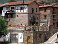
 Skyline of Ajamil de Cameros | |
 Municipality of Ajamil | |
42°10′01″N 2°29′14″W / 42.16694°N 2.48722°W / 42.16694; -2.48722 | |
| Country |  Spain Spain |
| Autonomous communities of Spain |  La Rioja La Rioja |
| Comarca | Camero Viejo |
| Government | |
| • Mayor | Eduardo García Galilea (PR+) |
| Area | |
| • Total | 66.15 km2 (25.54 sq mi) |
| Population (2018)[1] | |
| • Total | 62 |
| Demonym | ajamilense |
| Postal code | 26133 |
Ajamil (Spanish pronunciation: [a.xa.ˈmil]) is a village in the province and autonomous community of La Rioja, Spain. The municipality covers an area of 66.15 square kilometres (25.54 sq mi) and as of 2011 had a population of 80 people.[2]
Geography
There are two rivers: Vargas (also called Rabanera) and Vadillos, both tributaries of the Leza from the right.
In the south are located the northern foothills of the Sierra del Hayedo de Santiago, that connects with Cerro Castillo (1,683 m.) towards the west, which together have altitudes above 1,600 m and culminate in Canto Hincado (1,758 m.). This is the highest area of the municipality.
Just west of town is the Sierra de Camero Viejo (1,700, 1,300 m), which defines the town. The relief loses altitudes towards the north and east, (Potezuela, 1510 m., The Madorra. 1,470 m.). In the valleys of the Vadillos and Vargas river basins, the altitudes decrease as the course progresses.
History
In 1366 when Henry II of Castile de Trastámara was crowned king in Calahorra, the Navarro gentleman Juan Ramirez de Arellano received from him the Lordship of Cameros in return for services rendered. Ajamil was among the peoples and places of the said lordship and power passed to the counts of Aguilar and Cameros lords, until the abolition of the feudal system with the Spanish Constitution of 1812.
In the census of the population of Castilla in the 16th century, Ajamil contained, along with Najera, 50 residences, about 300 individuals. Until the creation of the province of Logroño (by decree of 30 November 1833) the village was exempted and belonged to the province of Soria with its own independent jurisdiction in advance.
Demographics
Population centres
- Ajamil
- Larriba
- Torremuña
- La Aldehuela
- La Edradilla
Economy
The city's economy primarily involves agricultural and livestock production. Agriculture is done on a small scale with production in kitchen gardens of borage, beet, potato, pepper, and fodder.
Livestock is the basis of the local economy, whose cottages comprise cattle and horses. The area of forested land exceeds 5,800 hectares. There is plenty of hunting, especially for wild boar.
Photo gallery
-
 Typical Camerata Arquitecture.
 -
 The town center.
 -
 Church of the Assumption (s. XVI-XVII).
 -
 One of his flowery balconies.
 -
 A typical street in the village.
 -
 One of its beautiful streets.


References
- ^ Municipal Register of Spain 2018. National Statistics Institute.
- ^ "La Rioja: Población por municipios y sexo:Cifras oficiales de población resultantes de la revisión del Padrón municipal a 1 de enero de 2011". Instituto Nacional de Estadística. Archived from the original on 21 May 2012. Retrieved 27 May 2012.
- v
- t
- e
Municipalities in La Rioja
- Ábalos
- Agoncillo
- Aguilar del Río Alhama
- Ajamil
- Albelda de Iregua
- Alberite
- Alcanadre
- Aldeanueva de Ebro
- Alesanco
- Alesón
- Alfaro
- Almarza de Cameros
- Anguciana
- Anguiano
- Arenzana de Abajo
- Arenzana de Arriba
- Arnedillo
- Arnedo
- Arrúbal
- Ausejo
- Autol
- Azofra
- Badarán
- Bañares
- Baños de Rioja
- Baños de Río Tobía
- Berceo
- Bergasa
- Bergasillas Bajera
- Bezares
- Bobadilla
- Brieva de Cameros
- Briones
- Briñas
- Cabezón de Cameros
- Calahorra
- Camprovín
- Canales de la Sierra
- Canillas de Río Tuerto
- Casalarreina
- Castañares de Rioja
- Castroviejo
- Cañas
- Cellorigo
- Cenicero
- Cervera del Río Alhama
- Cidamón
- Cihuri
- Cirueña
- Clavijo
- Cordovín
- Corera
- Cornago
- Corporales
- Cuzcurrita de Río Tirón
- Cárdenas
- Daroca de Rioja
- El Rasillo de Cameros
- El Redal
- El Villar de Arnedo
- Enciso
- Entrena
- Estollo
- Ezcaray
- Foncea
- Fonzaleche
- Fuenmayor
- Galbárruli
- Galilea
- Gallinero de Cameros
- Gimileo
- Grañón
- Grávalos
- Haro
- Herce
- Herramélluri
- Hervías
- Hormilla
- Hormilleja
- Hornillos de Cameros
- Hornos de Moncalvillo
- Huércanos
- Igea
- Jalón de Cameros
- Laguna de Cameros
- Lagunilla del Jubera
- Lardero
- Ledesma de la Cogolla
- Leiva
- Leza de Río Leza
- Logroño
- Lumbreras
- Manjarrés
- Mansilla de la Sierra
- Manzanares de Rioja
- Matute
- Medrano
- Munilla
- Murillo de Río Leza
- Muro de Aguas
- Muro en Cameros
- Nalda
- Navajún
- Navarrete
- Nestares
- Nieva de Cameros
- Nájera
- Ochánduri
- Ocón
- Ojacastro
- Ollauri
- Ortigosa de Cameros
- Pazuengos
- Pedroso
- Pinillos
- Pradejón
- Pradillo
- Préjano
- Quel
- Rabanera
- Ribafrecha
- Rincón de Soto
- Robres del Castillo
- Rodezno
- Sajazarra
- San Asensio
- San Millán de Yécora
- San Millán de la Cogolla
- San Román de Cameros
- San Torcuato
- San Vicente de la Sonsierra
- Santa Coloma
- Santa Engracia del Jubera
- Santa Eulalia Bajera
- Santo Domingo de la Calzada
- Santurde de Rioja
- Santurdejo
- Sojuela
- Sorzano
- Soto en Cameros
- Sotés
- Terroba
- Tirgo
- Tobía
- Tormantos
- Torre en Cameros
- Torrecilla en Cameros
- Torrecilla sobre Alesanco
- Torremontalbo
- Treviana
- Tricio
- Tudelilla
- Uruñuela
- Valdemadera
- Valgañón
- Ventosa
- Ventrosa
- Viguera
- Villalba de Rioja
- Villalobar de Rioja
- Villamediana de Iregua
- Villanueva de Cameros
- Villar de Torre
- Villarejo
- Villarroya
- Villarta-Quintana
- Villavelayo
- Villaverde de Rioja
- Villoslada de Cameros
- Viniegra de Abajo
- Viniegra de Arriba
- Zarratón
- Zarzosa
- Zorraquín

| Authority control databases |
|
|---|


