Aïn Témouchent Province
Province of Algeria
Province in Algeria
Aïn Témouchent Province ولاية عين تموشنت | |
|---|---|
Province | |
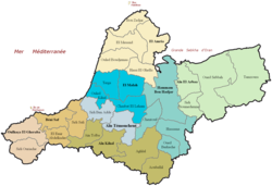 Administrative map of Aïn Témouchent province | |
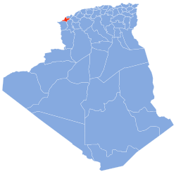 Map of Algeria highlighting Aïn Témouchent | |
| Coordinates: 35°18′N 01°08′W / 35.300°N 1.133°W / 35.300; -1.133 | |
| Country |  Algeria Algeria |
| Capital | Aïn Témouchent |
| Government | |
| • PPA president | Mr. Tikhmarine Lakhdar (تيخمارين لخضر) (FLN) |
| • Wāli | Mr. Bouderbali Mohamed (محمد بودربالي) |
| Area | |
| • Total | 2,376.89 km2 (917.72 sq mi) |
| Population (2010)[1] | |
| • Total | 384,565 |
| • Density | 160/km2 (420/sq mi) |
| Time zone | UTC+01 (CET) |
| Area Code | +213 (0) 27 |
| ISO 3166 code | DZ-46 |
| Districts | 8 |
| Municipalities | 28 |
Aïn Témouchent (Arabic: ولاية عين تموشنت) is a province (wilaya) in northwestern Algeria, named after its capital: Aïn Témouchent.
History
The province was created from Sidi Bel Abbès Province in 1984.
Administrative divisions
It is made up of 8 districts and 28 municipalities.
The districts are:
The municipalities are:
- Aghlal
- Aïn El Arbaa
- Aïn Kihal
- Aïn Témouchent
- Aïn Tolba
- Aoubellil
- Beni Saf
- Bou Zedjar
- Chaabet El Ham
- Chentouf
- El Amria
- El Emir Abdelkader
- El Malah
- El Messaid
- Hammam Bouhadjar
- Hassasna
- Hassi El Ghella
- Oued Berkeche
- Oued Sabah
- Ouled Boudjemaa
- Ouled Kihal
- Oulhaca El Gheraba
- Sidi Ben Adda
- Sidi Boumedienne
- Sidi Ouriache
- Sidi Safi
- Tamzoura
- Terga
References
 Algeria portal

- ^ Wilaya d'Aïn Témouchent Présentation/Population/Répartition de la population Archived 2010-08-27 at the Wayback Machine
External links
- (in French and Arabic) Official website
- v
- t
- e
- Adrar (01)
- Chlef (02)
- Laghouat (03)
- Oum El Bouaghi (04)
- Batna (05)
- Béjaïa (06)
- Biskra (07)
- Béchar (08)
- Blida (09)
- Bouira (10)
- Tamanrasset (11)
- Tébessa (12)
- Tlemcen (13)
- Tiaret (14)
- Tizi Ouzou (15)
- Algiers (16)
- Djelfa (17)
- Jijel (18)
- Sétif (19)
- Saïda (20)
- Skikda (21)
- Sidi Bel Abbès (22)
- Annaba (23)
- Guelma (24)
- Constantine (25)
- Médéa (26)
- Mostaganem (27)
- M'Sila (28)
- Mascara (29)
- Ouargla (30)
- Oran (31)
- El Bayadh (32)
- Illizi (33)
- Bordj Bou Arréridj (34)
- Boumerdès (35)
- El Taref (36)
- Tindouf (37)
- Tissemsilt (38)
- El Oued (39)
- Khenchela (40)
- Souk Ahras (41)
- Tipaza (42)
- Mila (43)
- Aïn Defla (44)
- Naâma (45)
- Aïn Témouchent (46)
- Ghardaïa (47)
- Relizane (48)
- Bordj Baji Mokhtar (49)
- In Salah (50)
- Djanet (51)
- In Guezzam (52)
- El M'Ghair (53)
- Touggourt (54)
- Béni Abbès (55)
- Timimoun (56)
- Ouled Djellal (57)
- El Menia (58)

Authority control databases | |
|---|---|
| International |
|
| National |
|
| Geographic |
|
 | This article about a location in Aïn Témouchent Province is a stub. You can help Wikipedia by expanding it. |
- v
- t
- e


