2nd Ward of New Orleans

Map of ward boundary
The 2nd Ward or Second Ward of New Orleans, Louisiana is one of the 17 Wards of New Orleans.[1]
Boundaries
The Ward fronts the Mississippi River. The down-river or "lower" boundary (in this case, to the northeast) is Julia Street, across which is the 3rd Ward. The boundary continues inland from the end of Julia, originally delineated by the New Basin Canal, now I-10, over the former route of the filled-in canal. The upper boundary is Thalia Street, across which is the 1st Ward, then Martin Luther King Jr. Boulevard (formerly Melpomene Avenue), across from which are portions of the 10th and 11th Wards, then Washington Avenue, across which is the 14th Ward.
Cityscape and landmarks
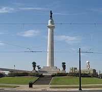
The area along the riverfront was part of the Old Warehouse District. The ward encompasses the upper portion of the New Orleans Central Business District, including Lee Circle, as well as a sliver of the Lower Garden District. Further inland the Ward continues through part of the Central City, including the B.W. Cooper or Calliope housing project.
References
- ^ New Orleans Districts and Wards Archived July 1, 2010, at the Wayback Machine
Wikimedia Commons has media related to 2nd Ward of New Orleans.
- v
- t
- e
 City of New Orleans
Universities
- Delgado Dolphins (Delgado)
- Dillard Bleu Devils and Lady Bleu Devils (Dillard)
- Loyola Wolf Pack (Loyola New Orleans)
- New Orleans Gold
- New Orleans Jesters
- New Orleans Pelicans
- New Orleans Privateers (UNO)
- New Orleans Saints
- New Orleans Breakers (2022)
- Southern–New Orleans Knights and Lady Knights (SUNO)
- Tulane Green Wave (Tulane)
- Xavier Gold Rush and Gold Nuggets (Xavier LA)
29°56′46″N 90°04′52″W / 29.946°N 90.081°W / 29.946; -90.081
 | This New Orleans, Louisiana–related article is a stub. You can help Wikipedia by expanding it. |
- v
- t
- e


